geo.wikisort.org - Isola
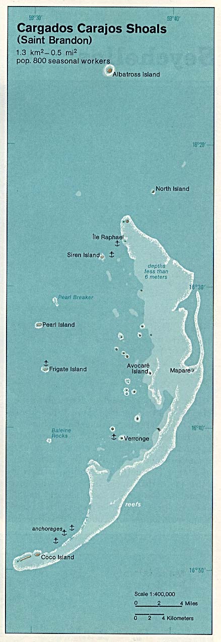
Le Cargados Carajos[1], conosciute anche come Saint Brandon, sono un gruppo di isolotti dell'Oceano indiano, a nord-est di Mauritius, di cui sono una dipendenza.
| Saint Brandon Cargados carajos | |
|---|---|
| Geografia fisica | |
| Localizzazione | Oceano Indiano |
| Coordinate | 16°35′S 59°37′E |
| Arcipelago | Isole Mascarene |
| Superficie | 1,2 km² |
| Geografia politica | |
| Stato | |
| Centro principale | Verronge |
| Demografia | |
| Abitanti | 35 circa |
| Cartografia | |
 | |
 Saint Brandon | |
| voci di isole di Mauritius presenti su Wikipedia | |
Hanno una superficie totale di 1,2 km² e una esigua popolazione (circa 35 persone nel 1996) sull'Isola Rafael nel villaggio di Verrogne.
Le isole fanno parte dell'arcipelago delle Isole Mascarene.
Principali isolette
- Albatross Island 16°19′00″S 59°36′00″E
- Îlot du Nord 16°19′00″S 59°39′00″E
- Île Raphael 16°27′00″S 59°37′00″E
- Îlot Siren 16°28′00″S 59°34′00″E
- Île Tortue 16°28′00″S 59°41′00″E
- Pearl Islet 16°31′00″S 59°32′00″E
- Île du Sud 16°32′00″S 59°32′00″E
- Avocare Island 16°35′00″S 59°40′00″E
- Mapare Islet 16°35′00″S 59°41′00″E
- Frigate Islet 16°37′00″S 59°31′00″E
- Îlote du Paul 16°37′00″S 59°33′00″E
- Baleine Rocks 16°41′00″S 59°30′00″E
- Île Veronge 16°41′00″S 59°37′00″E
- Veronge Ilot 16°42′00″S 59°38′00″E
- Palm Islet 16°45′00″S 59°35′00″E
- Coco Island 16°50′00″S 59°30′00″E
- Grande Capitane 16°40′00″S 59°50′00″E
- Petite Capitane 16°36′00″S 59°34′00″E
- Puits A Eau 16°39′00″S 59°34′00″E
- Île Poulailer 16°44′00″S 59°46′00″E
- Chaloupe 16°49′00″S 59°50′00″E
- Courson 16°48′00″S 59°30′00″E
Note
Voci correlate
Altri progetti
 Wikimedia Commons contiene immagini o altri file su Cargados Carajos
Collegamenti esterni
- Dati di Statoids.com, su statoids.com.
| Controllo di autorità | VIAF (EN) 238152753 · GND (DE) 7500104-4 · BNF (FR) cb11979983g (data) |
|---|
На других языках
[de] Cargados-Carajos-Inseln
Die Cargados-Carajos-Inseln (englisch Cargados Carajos Shoals) auch Saint Brandon sind eine Inselgruppe mit einem ausgedehnten Riff im Indischen Ozean, 407 Kilometer (Coco Island – Mauritius) nordöstlich von Mauritius (Coco Island – Port Louis 431 km). Sie liegen auf dem unterseeischen Maskarenen-Plateau und sind somit Teil der Inselgruppe der Maskarenen.[en] St. Brandon
Saint Brandon, also known as the Cargados Carajos Shoals, is an Indian Ocean archipelago about 430 kilometres (270 mi) northeast of Mauritius consisting of a number of sand banks, shoals and islets. Saint Brandon consists of five island groups, with about 28–40 islands and islets in total, depending on seasonal storms and related sand movements.[1] There are 22 named islands and shoals. The archipelago is low-lying and is prone to substantial submersion in severe weather.[citation needed] It has an aggregate land area estimated variously at 1.3 km2 (0.50 sq mi) and 500 acres (2.0 km2).[1] Economic activity in the region is limited to fishing on the very extensive shallow bank covering approximately 900 sq mi (2,300 km2) around the islands. By the early 19th century, most of the islands were in use as fishing stations. Geographically, the archipelago is part of the Mascarene Islands and is situated on the Mascarene Plateau formed by the separation of the Mauritia microcontinent during the separation of India and Madagascar about 60 million years ago.[es] Cargados Carajos
El banco de Cargados Carajos (también conocidos como las Rocas de San Brandón; en inglés, Saint Brandon Rocks) es un grupo de 16 pequeñas islas e islotes en un arrecife extendido en el océano Índico, al noreste de Mauricio. Las islas tienen un área total de tierra de 1,3 km². El arrecife mide más de 50 km de norte a sur y con 5 km de ancho, cortado por tres pasos; en total el área del arrecife abarca 190 km². Las islas tienen una pequeña población, conformada por nativos así como de otros lugares y posee una rica fauna y flora. Las islas son clasificadas como una dependencia de Mauricio, que está a más de 300 km al extremo sur, y son administrados desde Port Louis. Las islas son parte de las islas Mascareñas.[fr] Saint-Brandon
Saint Brandon, également connu sous le nom d’écueils des Cargados Carajos, est un archipel de l’océan Indien situé à environ 415 kilomètres au nord-nord-est de l'île Maurice, composé de bancs de sable et d’îlots.- [it] Cargados Carajos
[ru] Каргадос-Карахос
Каргадос-Карахос (англ. Cargados Carajos), также известны как скалы Святого Брендона (англ. Saint Brandon Rocks) — группа небольших островков (от 16 до 40) и коралловый риф в Индийском океане. Является частью Внешних островов Маврикия. Расположены в 300 км северо-восточнее острова Маврикий.Текст в блоке "Читать" взят с сайта "Википедия" и доступен по лицензии Creative Commons Attribution-ShareAlike; в отдельных случаях могут действовать дополнительные условия.
Другой контент может иметь иную лицензию. Перед использованием материалов сайта WikiSort.org внимательно изучите правила лицензирования конкретных элементов наполнения сайта.
Другой контент может иметь иную лицензию. Перед использованием материалов сайта WikiSort.org внимательно изучите правила лицензирования конкретных элементов наполнения сайта.
2019-2026
WikiSort.org - проект по пересортировке и дополнению контента Википедии
WikiSort.org - проект по пересортировке и дополнению контента Википедии