geo.wikisort.org - Coast
San Juan, officially the Municipality of San Juan (Tagalog: Bayan ng San Juan), is a 1st class municipality in the province of Batangas, Philippines. According to the 2020 census, it has a population of 114,068 people. [3]
San Juan | |
|---|---|
Municipality | |
| Municipality of San Juan | |
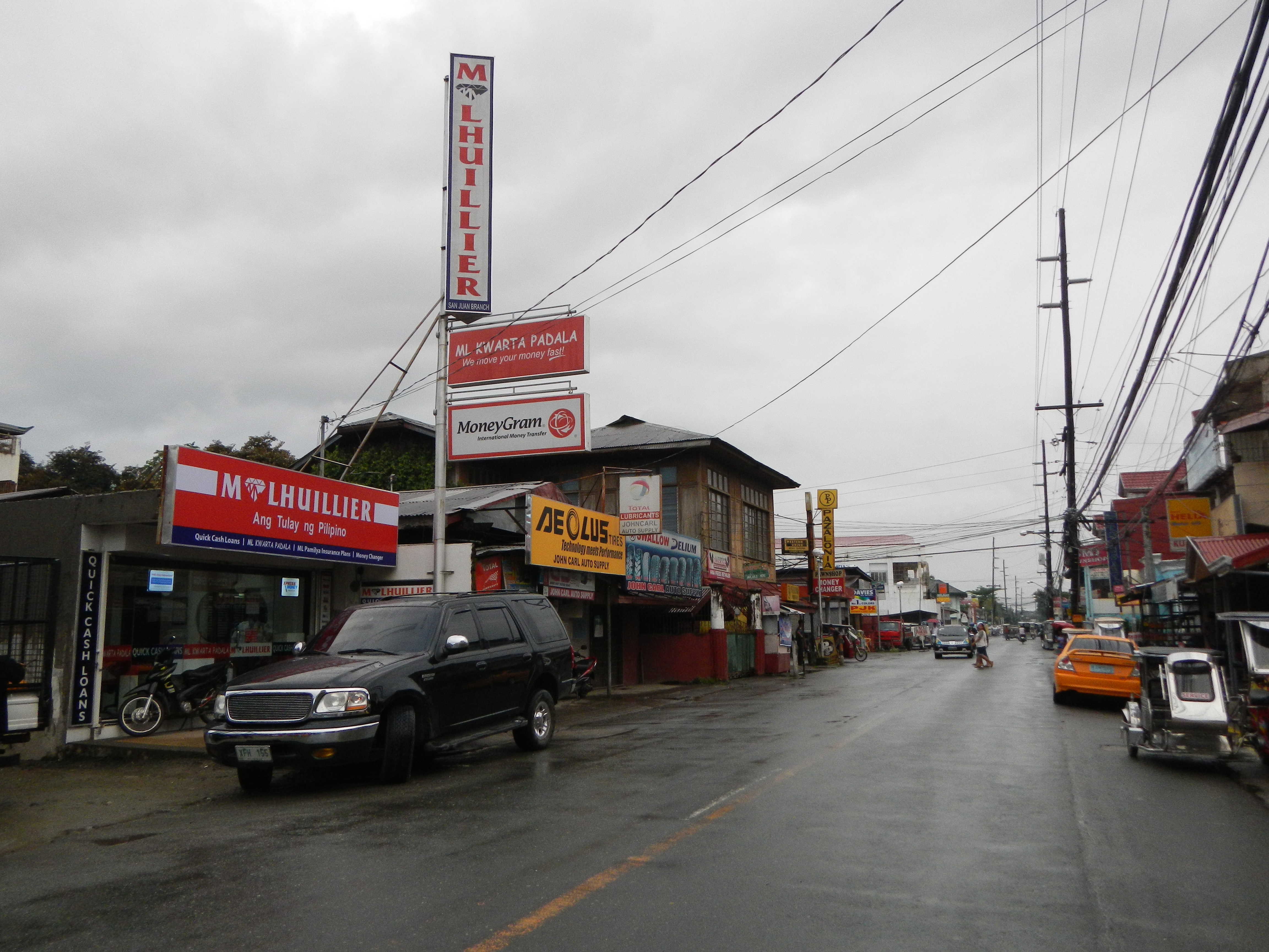 Gen. Luna Street, the town proper's main thoroughfare | |
 Flag  Seal | |
| Motto: Sama-sama Tayo sa Napapanahong Pagbabago | |
| Anthem: Bagong Araw (New Day) | |
 Map of Batangas with San Juan highlighted | |
OpenStreetMap  | |
 San Juan Location within the Philippines | |
| Coordinates: 13°49′34″N 121°23′46″E | |
| Country | Philippines |
| Region | Calabarzon |
| Province | Batangas |
| District | 4th district |
| Founded | December 12, 1848 |
| Named for | St. John of Nepomuk |
| Barangays | 42 (see Barangays) |
| Government | |
| • Type | Sangguniang Bayan |
| • Mayor | Ildebrando D. Salud |
| • Vice Mayor | Octavio Antonio L. Marasigan |
| • Representative | Lianda B. Bolilia |
| • Municipal Council | Members |
| • Electorate | 69,027 voters (2019) |
| Area | |
| • Total | 273.40 km2 (105.56 sq mi) |
| Elevation | 23 m (75 ft) |
| Highest elevation | 184 m (604 ft) |
| Lowest elevation | 0 m (0 ft) |
| Population | |
| • Total | 114,068 |
| • Density | 420/km2 (1,100/sq mi) |
| • Households | 23,713 |
| Economy | |
| • Income class | 1st municipal income class |
| • Poverty incidence | 13.04% (2018)[4] |
| • Revenue | ₱388,107,172.05 (2020) |
| • Assets | ₱888,024,559.64 (2020) |
| • Expenditure | ₱433,752,213.79 (2020) |
| • Liabilities | ₱116,937,000.17 (2020) |
| Service provider | |
| • Electricity | Batangas 2 Electric Cooperative (BATELEC 2) |
| Time zone | UTC+8 (PST) |
| ZIP code | 4226 |
| PSGC | |
| IDD : area code | +63 (0)43 |
| Native languages | Tagalog |
| Website | www |
The town is known for its baroque church and the Pinagbayanan excavation, the most important archaeological site in the municipality.
History
In the years 1698 until 1836, San Juan was just a barrio of the large town of Rosario located in the eastern part of Batangas. From 1837, the government of San Juan was governed by tinientes or Deputies with term of one to two years. However, when San Juan was recognized as a separate town in 1843, the position of tinientes was replaced by Cabezas de Barangay serving one for each new barrio. It was only in 1848 when the Spanish government officially recognized the independence of San Juan from its mother town of Rosario, and was given the name San Juan de Bocboc.[5]
San Juan was headed by a Gobernadorcillo in 1864. The first Goberdanorcillo was Don Camilo Perez, a prominent citizen who initiated the separation of San Juan from Rosario. He is considered as the founder of the town, and was honored for his contribution in public works and peace and order in the newly created town.
On October 28, 1883, San Juan experienced a major disaster due to continuous winds and intense storm rain. Huge flood from the Bancoro and Bangbang Rivers hit the town resulting to the destruction of houses, drowning of livestocks and planted crops, and the devastation of the church and its convent. In 1886, the flooding become worse in the town. The parish priest had to erect a temporary church and convent in a site seven kilometers away from the town.[6]
On January 18, 1886, the officials of the town initiated the transfer of the new town to Calitcalit. The transfer of the Lumang Bayan to its present location was approved by Governor General Valeriano Weyler on December 12, 1890, during the administration of Gobernadorcillo Benedicto De Villa. San Juan de Bocboc was renamed to Bolbok by virtue of Act No. 2390 dated February 28, 1914.[7] In the early years of 1920, Bolbok was then renamed as San Juan, in honor of San Juan Nepomuceno, the town's patron saint.[8]
On April 4, 1945, the town was liberated from Japanese occupation by the F Company, 188th Infantry of the United States Army as part of their clearing operations to liberate the Bicol peninsula from the hands of the Japanese.[9]
Geography
San Juan is located at 13°49′34″N 121°23′46″E, at the easternmost part of Batangas province. North of San Juan is the neighboring town of Candelaria, with Malaking Ilog River defining its geographical boundary. Tayabas Bay lies east and the hills on the eastern portion separate it from the towns of Lobo and Rosario.
According to the Philippine Statistics Authority, the municipality has a land area of 273.40 square kilometres (105.56 sq mi) [10] constituting 8.76% of the 3,119.75-square-kilometre- (1,204.54 sq mi) total area of Batangas.
Barangays

San Juan is politically subdivided into 42 barangays.[11]
| PSGC | Barangay | Population | ±% p.a. | |||
|---|---|---|---|---|---|---|
| 2020 [3] | 2010 [12] | |||||
| 041023001 | Abung | 1.9% | 2,119 | 1,947 | 0.81% | |
| 041023002 | Balagbag | 2.2% | 2,539 | 2,147 | 1.62% | |
| 041023003 | Barualte | 1.5% | 1,676 | 1,389 | 1.82% | |
| 041023004 | Bataan | 1.7% | 1,911 | 1,786 | 0.65% | |
| 041023005 | Buhay na Sapa | 4.5% | 5,123 | 3,751 | 3.03% | |
| 041023006 | Bulsa | 1.9% | 2,160 | 1,543 | 3.27% | |
| 041023007 | Calicanto | 1.7% | 1,957 | 1,908 | 0.24% | |
| 041023008 | Calitcalit | 4.0% | 4,556 | 4,128 | 0.95% | |
| 041023009 | Calubcub I | 1.9% | 2,206 | 1,794 | 2.00% | |
| 041023010 | Calubcub II | 3.1% | 3,529 | 3,360 | 0.47% | |
| 041023011 | Catmon | 1.2% | 1,418 | 1,282 | 0.97% | |
| 041023012 | Coloconto | 0.7% | 758 | 702 | 0.74% | |
| 041023013 | Escribano | 2.9% | 3,255 | 2,844 | 1.30% | |
| 041023014 | Hugom | 1.4% | 1,578 | 1,301 | 1.87% | |
| 041023015 | Imelda (Tubog) | 0.8% | 959 | 909 | 0.51% | |
| 041023016 | Janaojanao | 1.3% | 1,511 | 1,466 | 0.29% | |
| 041023017 | Laiya‑Ibabao | 3.9% | 4,504 | 3,580 | 2.22% | |
| 041023018 | Laiya‑Aplaya | 5.3% | 6,005 | 5,572 | 0.72% | |
| 041023019 | Libato | 3.6% | 4,107 | 3,997 | 0.26% | |
| 041023020 | Lipahan | 3.8% | 4,380 | 3,814 | 1.33% | |
| 041023021 | Mabalanoy | 3.4% | 3,834 | 3,155 | 1.88% | |
| 041023022 | Nagsaulay | 2.3% | 2,604 | 2,404 | 0.77% | |
| 041023023 | Maraykit | 3.1% | 3,574 | 3,060 | 1.50% | |
| 041023024 | Muzon | 1.3% | 1,539 | 1,497 | 0.27% | |
| 041023025 | Palahanan I | 0.7% | 841 | 713 | 1.59% | |
| 041023026 | Palahanan II | 2.8% | 3,234 | 2,954 | 0.87% | |
| 041023027 | Palingowak | 1.4% | 1,632 | 1,469 | 1.01% | |
| 041023028 | Pinagbayanan | 1.3% | 1,508 | 1,173 | 2.44% | |
| 041023029 | Poblacion | 2.9% | 3,281 | 3,111 | 0.51% | |
| 041023030 | Poctol | 2.7% | 3,028 | 2,216 | 3.04% | |
| 041023031 | Pulangbato | 2.4% | 2,767 | 2,391 | 1.41% | |
| 041023032 | Putingbuhangin | 2.2% | 2,491 | 1,872 | 2.77% | |
| 041023033 | Quipot | 2.9% | 3,328 | 2,517 | 2.71% | |
| 041023034 | Sampiro | 2.8% | 3,151 | 2,690 | 1.53% | |
| 041023035 | Sapangan | 2.6% | 2,940 | 2,435 | 1.82% | |
| 041023036 | Sico I | 1.7% | 1,977 | 1,700 | 1.46% | |
| 041023037 | Sico II | 1.0% | 1,100 | 934 | 1.58% | |
| 041023038 | Subukin | 1.4% | 1,635 | 1,444 | 1.20% | |
| 041023039 | Talahiban I | 2.0% | 2,244 | 2,055 | 0.85% | |
| 041023040 | Talahiban II | 1.1% | 1,301 | 1,261 | 0.30% | |
| 041023041 | Ticalan | 1.6% | 1,830 | 1,486 | 2.01% | |
| 041023042 | Tipaz | 2.6% | 2,975 | 2,534 | 1.55% | |
| Total | 114,068 | 94,291 | 1.84% | |||
Climate
| Climate data for San Juan, Batangas | |||||||||||||
|---|---|---|---|---|---|---|---|---|---|---|---|---|---|
| Month | Jan | Feb | Mar | Apr | May | Jun | Jul | Aug | Sep | Oct | Nov | Dec | Year |
| Average high °C (°F) | 27 (81) |
28 (82) |
30 (86) |
32 (90) |
31 (88) |
30 (86) |
29 (84) |
29 (84) |
29 (84) |
29 (84) |
28 (82) |
27 (81) |
29 (84) |
| Average low °C (°F) | 21 (70) |
20 (68) |
21 (70) |
22 (72) |
24 (75) |
24 (75) |
24 (75) |
24 (75) |
24 (75) |
23 (73) |
22 (72) |
22 (72) |
23 (73) |
| Average precipitation mm (inches) | 52 (2.0) |
35 (1.4) |
27 (1.1) |
27 (1.1) |
82 (3.2) |
124 (4.9) |
163 (6.4) |
144 (5.7) |
145 (5.7) |
141 (5.6) |
100 (3.9) |
102 (4.0) |
1,142 (45) |
| Average rainy days | 12.0 | 8.1 | 8.8 | 9.7 | 17.9 | 22.6 | 26.2 | 24.5 | 24.6 | 22.0 | 16.7 | 14.9 | 208 |
| Source: Meteoblue (modeled/calculated data, not measured locally)[13] | |||||||||||||
Demographics
|
|
| ||||||||||||||||||||||||||||||||||||||||||||||||||||||
| Source: Philippine Statistics Authority [14] [12] [15][16] | ||||||||||||||||||||||||||||||||||||||||||||||||||||||||
In the 2020 census, San Juan had a population of 114,068. [3] The population density was 420 inhabitants per square kilometre (1,100/sq mi).
Economy

San Juan is a first class municipality in the province of Batangas. It is initially identified as one of the Special Economic Zones ( ECOZONES). According to RA 7916 or the Special Economic Zone Act of 1995, ecozones are selected areas with highly developed or which have the potential to be developed into agro-industrial, industrial, tourist/recreational, commercial, banking, investment and financial centers.[24]
San Juan is a tourist destination known for its white-sand beaches. The tourism and aquaculture industries provide jobs to the town's people and income to the town economy.
Because of its fertile land, the municipality is one of the top suppliers of agricultural products in the province.
The town has also a coconut wine and pottery industry.
Income
Here's the list of the total annual income, assets, expenses and equity of San Juan since 2015, according to the Annual Audit Reports of the Commission on Audit:
| Year | Total Annual Income | Assets | Expenses | Equity |
|---|---|---|---|---|
| 2020[25] | ₱527,484,244.43 | ₱888,024,559.64 | ₱431,318,667.12 | ₱771,087,559.47 |
| 2019[26] | ₱359,577,041.16 | ₱777,617,737.52 | ₱314,756,691.59 | ₱679,909,608.45 |
| 2018[27] | ₱326,581,854.00 | ₱714,378,369.54 | ₱290,098,959.77 | ₱616,441,566.44 |
| 2017[28] | ₱307,359,289.40 | ₱631,222,065.04 | ₱250,243,204.16 | ₱522,162,348.18 |
| 2016[29] | ₱258,671,588.66 | ₱634,400,575.24 | ₱208,687,514.58 | ₱532,424,224.13 |
| 2015[30] | ₱237,642,431.61 | ₱310,971,370.24 | ₱180,286,101.48 | ₱232,961,446.48 |
Government
Government officials

The 2022 local elections in San Juan was held on May 9, 2022. Five municipal councilors, elected on May 13, 2019, were re-elected while the three others will serve their first term. The following are the elected government officials of San Juan. Their term will expire on June 30, 2025.
| Municipal Government of San Juan (2022-2025) | |
|---|---|
| Mayor | |
| Ildebrando D. Salud | |
| Vice Mayor | |
| Octavio Antonio L. Marasigan | |
| Sangguniang Bayan Members | |
| Wenilo G. Ada | Gerardo R. Tantay Jr. |
| Florencio M. De Chavez | Meynardo V. Robles |
| Angelo Luis T. Marasigan | Rodello A. De Chavez |
| Rowena M. Magadia | Grenalyn L. Virtusio, Ll. B. |
| ABC President | |
| Wivin R. Llana | |
| SK Federation President | |
| Joel S. Rey, Jr. | |
List of former Municipal Mayors
| Order | Name | Years in Office | Achievement |
|---|---|---|---|
| 1 | Don Esteban de Villa | 1900-1905 | Built the town's public market |
| 2 | Don Gregorio de Villa | 1905-1906 | Constructed the town's elementary school (Gabaldon) |
| 3 | Don Benedicto de Villa | 1906-1907 | Pioneered the town's sugar industry that brought prosperity to the town |
| 4 | Don Raymundo Balinos | 1907-1910 | Encouraged the education of the town's people |
| 5 | Don Florencio Perez | 1910-1913 | Built a public cemetery for the poor and the non-Catholics |
| 6 | Don Gregorio de Villa | 1913-1916 | |
| 7 | Don Esteban de Villa | 1916-1919 | |
| 8 | Don Juan R. Quizon | 1919-1922 | Constructed the municipal building and acquired the site for the town plaza |
| 9 | Don Nicolas Virrey | 1922-1925 | |
| 10 | Don Juan R. Quizon | 1925-1928 | |
| 11 | Don Filemon Malabanan | 1928-1934 | Built the water reservoir and worked for the electrification of the town |
| 12 | Don Miguel Lopez | 1934-1942 | Instrumental in the building of San Juan East Central School |
| 13 | Guillermo de Villa | 1942-1945 | Maintained peaceful relationship with the Japanese government while working secretly with the guerillas |
| 14 | Vicente Castillo | 1945; 1946-1955 | Built the Lawaye River Dike, and organized the town's police force |
| 15 | Jose Garcia | 1956-1963 | Built the Sampiro-Quipot feeder road |
| 16 | Estelito Castillo | 1964-1967 | Repaired municipal building, implemented the minimum wage law, and managed to acquire fire trucks from the national government |
| 17 | Vicente Lecaroz | 1968-1986 | Built feeder roads and bridges; responsible for the construction of additional school buildings; he also eradicated cattle-rustling |
| 18 | Abelardo de Villa | 1986-1998 | Electrification of barrios; built new feeder roads, new bridges and cemented road to Laiya. |
| 19 | Rodolfo Hernandez Manalo | 1998-2007 | a) Carried out the Computerization of Real Property Tax Administration and Business Permit and Licensing System. b) Build Farm to Market Roads and Bridges. |
| 20 | Danilo Salapare Mindanao | 2007-2010 | Asphalting of roads; he envisioned the cityhood of San Juan |
| 21 | Rodolfo Hernandez Manalo | 2010‑2019 | Establishment of 13 national high schools, opening of barangay roads and massive concreting of Farm To Market Roads, construction of hanging and foot bridge in various barangays, scholarships to indigent constituents from elementary to college, massive mangrove rehabilitation, tree planting, no to mining, no to plastics, regulated cutting of trees. |
| 22 | Ildebrando Danias Salud | 2019‑present |
Official seal
- Horse – The municipality is known for its horses and other farm animals like cows, pigs, and goats.
- Tuba Container – locally known as batang, a container in which tuba is gathered from the coconut tree.
- Fruits – Fruits such as mangoes, citrus, atis and tamarind which are grown abundantly in the town.
- Roundels – signifies the number of barangays (42) comprising the municipality
Tourism


On June 29, 2010, then President Gloria Macapagal Arroyo signed the Executive Order No. 904, series of 2010 designating the Municipality of San Juan, Batangas as a priority area for Tourism Development.[31]
Attractions include:
- San Juan Nepomuceno Church – The church was built during the Spanish colonial period.
- Laiya Beach – San Juan has a coastline with several beach resorts for swimming, diving and other outdoor activities
- Mount Daguldol – The highest mountain in San Juan, 670 metres (2,200 ft) high
- Mangrove Forest at Barangay Poctol – One of the largest mangrove areas in San Juan; located in Sitio Pontor
- Ancestral houses – Built during Spanish and American colonial periods in the town.
- Municipal Hall – Erected on 1928 under the administration of Juan R. Quizon, the then Presidente Municipal. It has a simple yet enticing architectural style
- Malaking River at Barangay Poctol – This river serves as a boundary between Batangas and Quezon Province.
- Naambon Falls - A secluded, undisturbed series of falls and small pools. It has several look-out points with views of dense forest and Tayabas Bay.[32]
Education
Private schools in town include Joseph Marello Institute, and Batangas Eastern Colleges, founded in 1947 and 1940 respectively. San Juan has also a campus of Batangas State University located at Barangay Talahiban II.
Almost all barangays have their own elementary and high schools, where tuition fees are relatively low.
Despite improvements of the town's education system, parents of some students from well-off families send their children to Metro Manila for college.
Notable personalities
- Renato de Villa – Former Chief of Staff, Armed Forces of the Philippines; Former Secretary, Department of National Defense; 1998 Presidential Election Candidate
- Rudy Salud – Founding Secretary General, World Boxing Council; Former PBA Commissioner; Boxing Manager and Promoter
- Leandro Mendoza – Former Executive Secretary under President Gloria Macapagal Arroyo; Former Police Director General, Philippine National Police (2001)
- Salvador Q. Quizon – Auxiliary Bishop-Emeritus, Archdiocese of Lipa
- Alyssa Valdez – Volleyball player, Ateneo Lady Eagles
- Meynardo A. Sabili – former Mayor of Lipa City
References
- Municipality of San Juan | (DILG)
- "2015 Census of Population, Report No. 3 – Population, Land Area, and Population Density" (PDF). Philippine Statistics Authority. Quezon City, Philippines. August 2016. ISSN 0117-1453. Archived (PDF) from the original on May 25, 2021. Retrieved July 16, 2021.
- Census of Population (2020). "Region IV-A (Calabarzon)". Total Population by Province, City, Municipality and Barangay. PSA. Retrieved 8 July 2021.
- "PSA Releases the 2018 Municipal and City Level Poverty Estimates". Philippine Statistics Authority. 15 December 2021. Retrieved 22 January 2022.
- "A Glimpse of History". sanjuanbatangas.gov.ph.
- "The San Juan Batangas Legacy" (PDF). Arch. Leon M. Mayo.
- Act No. 2390 (28 February 1914), An Act Changing the names of the municipalities of Santo Niño and Mawanan, Province of Cagayan; San Isidro Labrador and San Isidro de Potot, Province of Pangasinan; San Francisco de Malabon and Santa Cruz de Malabon, Province of Cavite; Nagpartian and San Miguel, Province of Ilocos Norte; Langaran, Province of Misamis; San Pedro Tunasan, Province of Laguna; Cabagan Nuevo, Province of Isabela; Nueva Caceres, Province of Ambos Camarines; San Pedro Macati, Province of Rizal; San Juan de Bocboc, Province of Batangas; San Juan, Province of Nueva Ecija; township of Barrit - Luluno, Province of Ilocos Sur, and of the Barrios of Tublijon and Gibigaan, Municipality of Sorsogon, Province of Sorsogon., retrieved July 18, 2022
- "A Glimpse of History". sanjuanbatangas.gov.ph.
- Buhay Batangas (March 3, 2018). "DATES WHEN EACH TOWN OF BATANGAS WAS LIBERATED FROM THE JAPANESE IN WWII". Batangas History. Retrieved August 5, 2021.
- "Province: Batangas". PSGC Interactive. Quezon City, Philippines: Philippine Statistics Authority. Retrieved 12 November 2016.
- "Municipal: San Juan, Batangas". PSGC Interactive. Quezon City, Philippines: Philippine Statistics Authority. Retrieved 8 January 2016.
- Census of Population and Housing (2010). "Region IV-A (Calabarzon)". Total Population by Province, City, Municipality and Barangay. NSO. Retrieved 29 June 2016.
- "San Juan: Average Temperatures and Rainfall". Meteoblue. Retrieved 5 May 2020.
- Census of Population (2015). "Region IV-A (Calabarzon)". Total Population by Province, City, Municipality and Barangay. PSA. Retrieved 20 June 2016.
- Censuses of Population (1903–2007). "Region IV-A (Calabarzon)". Table 1. Population Enumerated in Various Censuses by Province/Highly Urbanized City: 1903 to 2007. NSO.
- "Province of Batangas". Municipality Population Data. Local Water Utilities Administration Research Division. Retrieved 17 December 2016.
- "Poverty incidence (PI):". Philippine Statistics Authority. Retrieved 28 December 2020.
- https://psa.gov.ph/sites/default/files/NSCB_LocalPovertyPhilippines_0.pdf; publication date: 29 November 2005; publisher: Philippine Statistics Authority.
- https://psa.gov.ph/sites/default/files/2003%20SAE%20of%20poverty%20%28Full%20Report%29_1.pdf; publication date: 23 March 2009; publisher: Philippine Statistics Authority.
- https://psa.gov.ph/sites/default/files/2006%20and%202009%20City%20and%20Municipal%20Level%20Poverty%20Estimates_0_1.pdf; publication date: 3 August 2012; publisher: Philippine Statistics Authority.
- https://psa.gov.ph/sites/default/files/2012%20Municipal%20and%20City%20Level%20Poverty%20Estima7tes%20Publication%20%281%29.pdf; publication date: 31 May 2016; publisher: Philippine Statistics Authority.
- https://psa.gov.ph/sites/default/files/City%20and%20Municipal-level%20Small%20Area%20Poverty%20Estimates_%202009%2C%202012%20and%202015_0.xlsx; publication date: 10 July 2019; publisher: Philippine Statistics Authority.
- "PSA Releases the 2018 Municipal and City Level Poverty Estimates". Philippine Statistics Authority. 15 December 2021. Retrieved 22 January 2022.
- "Republic Act No. 7916". Official Gazette of the Republic of the Philippines.
- "2020 COA Annual Audit Report for San Juan, Batangas". Commission on Audit.
- "2019 COA Annual Audit Report for San Juan, Batangas". Commission on Audit.
- "2018 COA Annual Audit Report for San Juan, Batangas". Commission on Audit.
- "2017 COA Annual Financial Report for Local Government Unit". Commission on Audit.
- "2016 COA Annual Financial Report for Local Government Unit". Commission on Audit.
- "2015 COA Annual Financial Report for Local Government Unit". Commission on Audit.
- "Executive Order No. 904 s. 2010". Official Gazette of the Republic of the Philippines.
- "San Juan Batangas". sanjuanbatangas.gov.ph. Retrieved 11 December 2016.
External links
 Media related to San Juan, Batangas at Wikimedia Commons
- Philippine Standard Geographic Code
Places adjacent to San Juan, Batangas | ||||||||||||||||
|---|---|---|---|---|---|---|---|---|---|---|---|---|---|---|---|---|
| ||||||||||||||||

На других языках
[de] San Juan (Batangas)
San Juan ist eine philippinische Stadtgemeinde in der Provinz Batangas. Sie hat 108.585 Einwohner (Zensus 1. August 2015). Im Süden der Gemeinde liegt die stark befahrene Schifffahrtsroute der Isla-Verde-Straße. Diese gilt als ein Hotspot der Biodiversität der Unterwasserwelt auf den Philippinen und weltweit. Im Osten der Gemeinde liegt die Bucht von Tayabas.- [en] San Juan, Batangas
Другой контент может иметь иную лицензию. Перед использованием материалов сайта WikiSort.org внимательно изучите правила лицензирования конкретных элементов наполнения сайта.
WikiSort.org - проект по пересортировке и дополнению контента Википедии