geo.wikisort.org - Coast
Calatagan, officially the Municipality of Calatagan (Tagalog: Bayan ng Calatagan), is a 2nd class municipality in the province of Batangas, Philippines. According to the 2020 census, it has a population of 58,719 people. [3]
Calatagan
Bayan ng Calatagan Kalatagan | |
|---|---|
Municipality | |
| Municipality of Calatagan | |
Clockwise from top: Beach, Cape Santiago Lighthouse, Sto. Domingo de Silos Parish, Port of Calatagan, View of Southern Calatagan, Calatagan Municipal Hall | |
 Seal | |
 Map of Batangas with Calatagan highlighted | |
OpenStreetMap  | |
 Calatagan Location within the Philippines | |
| Coordinates: 13°49′56″N 120°37′56″E | |
| Country | Philippines |
| Region | Calabarzon |
| Province | Batangas |
| District | 1st district |
| Founded | January 1, 1912 |
| Barangays | 25 (see Barangays) |
| Government | |
| • Type | Sangguniang Bayan |
| • Mayor | Peter Oliver M. Palacio |
| • Vice Mayor | Rogelio H. Zarraga |
| • Representative | Joseph Eric R. Buhain |
| • Municipal Council | Members |
| • Electorate | 34,311 voters (2019) |
| Area | |
| • Total | 112.00 km2 (43.24 sq mi) |
| Elevation | 6.0 m (19.7 ft) |
| Highest elevation | 347 m (1,138 ft) |
| Lowest elevation | 0 m (0 ft) |
| Population | |
| • Total | 58,719 |
| • Density | 520/km2 (1,400/sq mi) |
| • Households | 13,337 |
| Economy | |
| • Income class | 2nd municipal income class |
| • Poverty incidence | 11.71% (2018)[4] |
| • Revenue | ₱216,161,124.49 (2020) |
| • Assets | ₱627,305,580.75 (2020) |
| • Expenditure | ₱193,695,820.63 (2020) |
| • Liabilities | ₱151,787,220.82 (2020) |
| Service provider | |
| • Electricity | Batangas 1 Electric Cooperative (BATELEC 1) |
| Time zone | UTC+8 (PST) |
| ZIP code | 4215 |
| PSGC | |
| IDD : area code | +63 (0)43 |
| Native languages | Tagalog |
| Website | www |


Calatagan comprises the Calatagan Peninsula between the South China Sea and Balayan Bay. The peninsula's near white sand beaches are well-known vacation and leisure sites. There are several beach resorts including the Banak House Calatagan on Calatagan beach, the Ronco Beach Resort in barangay Bagong Silang, Playa Calatagan in barangay Santa Ana, the Golden Sunset Resort in barangay Uno, Lago de Oro Resort in barangay Balibago, Villa Agustina in barangay Bagong Silang, and Nacua Sea Park in barangay Quilitisan. Calatagan was formerly titled as the Forbes Park of the South, because of the rich families who own estates here.[citation needed]
An extremely rare example of pre-Spanish Philippine script was found in Calatagan. The script is called Baybayin in Tagalog, and was derived from Javanese writing, which in turn is derived from Brahmi. This writing survived on an earthenware burial jar dated to the 13th or 14th century.[citation needed] A Spanish lighthouse can also be found at Cape Santiago at the peninsula's southern tip dating back to the 1890s and is also one of the municipality's main tourist attractions.
Etymology
The word "Calatagan" is taken from the Tagalog word "latag" and is closely associated with "kapatagan", which means a vast portion of flat land lying between the hills and mountains. Thus, Calatagan means a large expanse of wide flat land.[5]
History
The town is the site of the historically and archaeologically famous Calatagan Excavation whose antique pottery and utensils contributed important facts about the culture and activities of the Filipinos before the coming of the Spaniards. Chinese pottery, unearthed from six large cemeteries by archaeologists Olov T.R Jones and Robert B. Fox led to a conclusion made by H. Otley Bayer which points out the existence of a sizable pre-Spanish population in the town. The same studies suggested that there were direct Chinese trade by water in Calatagan and centered at a place called Balong-Bato, wherein an entrance through the reef, which surrounds Calatagan, is still presently used by vessels coming from Mindoro and Manila.
The land occupied by the municipality of Calatagan was acquired by Domingo Roxas from the Spanish Crown in 1829 and was called Hacienda de Calatagan. The successors Pedro P. Roxas and Antonio R. Roxas continued to develop it.
In 1912, through Executive Order No. 78 by then Governor-General William Cameron Forbes, Calatagan became a municipality independent from its mother municipality, Balayan.[6]
In 1931, Carmen Roxas, the last heir of the Roxas Clan transferred ownership of the Hacienda to the Zobel brothers, Jacobo and Alfonso. During the time of the Zobels, the hacienda came to be known as Central Azucarera de Calatagan or simply "Central Carmen" when referring to the sugar milling complex.
In 1934, the barangays of Baha and Talibayog, which were parts of Balayan at the time, were annexed to Calatagan since surveys showed that they are part of the land titled to the original owner of Hacienda Calatagan. This added a big area to the municipality.
On October 28, 1957, a decade after the Philippines gained independence from the Americans, the Land Tenure Administration, upon petition of the people of Calatagan bought the Hacienda Lands from the Zobels. These were apportioned to the inhabitants and sold to them at ₱5.00 per hectare payable in installment within a period of 25 years.[5]
Geography
Calatagan is located at 13°49′56″N 120°37′56″E.
According to the Philippine Statistics Authority, the municipality has a land area of 112.00 square kilometres (43.24 sq mi) [7] constituting 3.59% of the 3,119.75-square-kilometre- (1,204.54 sq mi) total area of Batangas.
Calatagan is 71 kilometres (44 mi) from Batangas City and 129 kilometres (80 mi) from Manila.
Barangays
Calatagan is politically subdivided into 25 barangays.[8]
| PSGC | Barangay | Population | ±% p.a. | |||
|---|---|---|---|---|---|---|
| 2020 [3] | 2010 [9] | |||||
| 041008001 | Bagong Silang | 3.9% | 2,270 | 2,074 | 0.87% | |
| 041008002 | Baha | 0.0% | 0 | 1,494 | −100.00% | |
| 041008003 | Balibago | 5.8% | 3,377 | 3,161 | 0.64% | |
| 041008004 | Balitoc | 5.1% | 3,023 | 2,814 | 0.69% | |
| 041008005 | Biga | 4.9% | 2,849 | 2,795 | 0.18% | |
| 041008006 | Bucal | 1.6% | 965 | 892 | 0.76% | |
| 041008007 | Carlosa | 2.4% | 1,414 | 1,253 | 1.16% | |
| 041008008 | Carretunan | 2.6% | 1,504 | 1,449 | 0.36% | |
| 041008009 | Encarnacion | 2.3% | 1,327 | 1,049 | 2.28% | |
| 041008010 | Gulod | 5.3% | 3,127 | 2,798 | 1.07% | |
| 041008011 | Hukay | 3.6% | 2,120 | 2,124 | −0.02% | |
| 041008013 | Lucsuhin | 7.7% | 4,528 | 4,299 | 0.50% | |
| 041008014 | Luya | 1.1% | 664 | 616 | 0.72% | |
| 041008015 | Paraiso | 2.3% | 1,346 | 1,133 | 1.66% | |
| 041008016 | Barangay 1 (Poblacion) | 5.8% | 3,433 | 3,150 | 0.83% | |
| 041008017 | Barangay 2 (Poblacion) | 2.4% | 1,408 | 1,296 | 0.80% | |
| 041008018 | Barangay 3 (Poblacion) | 1.6% | 953 | 760 | 2.19% | |
| 041008019 | Barangay 4 (Poblacion) | 4.9% | 2,863 | 2,770 | 0.32% | |
| 041008020 | Quilitisan | 3.7% | 2,176 | 2,022 | 0.71% | |
| 041008021 | Real | 2.7% | 1,588 | 1,380 | 1.35% | |
| 041008022 | Sambungan | 3.4% | 1,975 | 1,820 | 0.79% | |
| 041008023 | Santa Ana | 5.5% | 3,209 | 2,747 | 1.50% | |
| 041008026 | Talibayog | 0.3% | 200 | 1,783 | −18.91% | |
| 041008027 | Talisay | 4.5% | 2,617 | 2,524 | 0.35% | |
| 041008028 | Tanagan | 7.2% | 4,224 | 3,794 | 1.03% | |
| Total | 58,719 | 51,997 | 1.17% | |||
Climate
| Climate data for Calatagan, Batangas | |||||||||||||
|---|---|---|---|---|---|---|---|---|---|---|---|---|---|
| Month | Jan | Feb | Mar | Apr | May | Jun | Jul | Aug | Sep | Oct | Nov | Dec | Year |
| Average high °C (°F) | 29 (84) |
30 (86) |
31 (88) |
33 (91) |
32 (90) |
30 (86) |
29 (84) |
29 (84) |
29 (84) |
29 (84) |
29 (84) |
29 (84) |
30 (86) |
| Average low °C (°F) | 20 (68) |
20 (68) |
21 (70) |
22 (72) |
24 (75) |
24 (75) |
24 (75) |
24 (75) |
24 (75) |
23 (73) |
22 (72) |
21 (70) |
22 (72) |
| Average precipitation mm (inches) | 11 (0.4) |
13 (0.5) |
14 (0.6) |
32 (1.3) |
101 (4.0) |
142 (5.6) |
208 (8.2) |
187 (7.4) |
175 (6.9) |
131 (5.2) |
68 (2.7) |
39 (1.5) |
1,121 (44.3) |
| Average rainy days | 5.2 | 5.0 | 7.4 | 11.5 | 19.8 | 23.5 | 27.0 | 25.9 | 25.2 | 23.2 | 15.5 | 8.3 | 197.5 |
| Source: Meteoblue (Use with caution: this is modeled/calculated data, not measured locally.)[10] | |||||||||||||
Demographics
| Year | Pop. | ±% p.a. |
|---|---|---|
| 1903 | 2,654 | — |
| 1918 | 4,636 | +3.79% |
| 1939 | 7,710 | +2.45% |
| 1948 | 9,620 | +2.49% |
| 1960 | 14,457 | +3.45% |
| 1970 | 20,889 | +3.74% |
| 1975 | 23,648 | +2.52% |
| 1980 | 27,578 | +3.12% |
| 1990 | 35,543 | +2.57% |
| 1995 | 40,707 | +2.57% |
| 2000 | 45,068 | +2.21% |
| 2007 | 51,544 | +1.87% |
| 2010 | 51,997 | +0.32% |
| 2015 | 56,449 | +1.58% |
| 2020 | 58,719 | +0.78% |
| Source: Philippine Statistics Authority [11] [9] [12][13] | ||
In the 2020 census, Calatagan had a population of 58,719. [3] The population density was 520 inhabitants per square kilometre (1,300/sq mi).
Economy
Gallery
 Municipal Hall
 Downtown Calatagan
 Plaza
Plaza Santo Domingo de Silos Parish Church
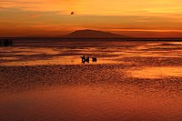 Sunset at a Beach in Calatagan
 Port of Calatagan


References
- Municipality of Calatagan | (DILG)
- "2015 Census of Population, Report No. 3 – Population, Land Area, and Population Density" (PDF). Philippine Statistics Authority. Quezon City, Philippines. August 2016. ISSN 0117-1453. Archived (PDF) from the original on May 25, 2021. Retrieved July 16, 2021.
- Census of Population (2020). "Region IV-A (Calabarzon)". Total Population by Province, City, Municipality and Barangay. PSA. Retrieved 8 July 2021.
- "PSA Releases the 2018 Municipal and City Level Poverty Estimates". Philippine Statistics Authority. 15 December 2021. Retrieved 22 January 2022.
- "Brief Description of LGU". Calatagan LGU Website. Archived from the original on 2 July 2014. Retrieved 14 June 2014.
- Batangas History (3 February 2018). "Executive Order No. 78 Separating Calatagan from the Municipality of Balayan". Batangas History, Culture and Folklore. Retrieved 1 February 2022.
- "Province: Batangas". PSGC Interactive. Quezon City, Philippines: Philippine Statistics Authority. Retrieved 12 November 2016.
- "Municipal: Calatagan". PSGC Interactive. Quezon City, Philippines: Philippine Statistics Authority. Retrieved 8 January 2016.
- Census of Population and Housing (2010). "Region IV-A (Calabarzon)". Total Population by Province, City, Municipality and Barangay. NSO. Retrieved 29 June 2016.
- "Calatagan: Average Temperatures and Rainfall". Meteoblue. Retrieved 5 May 2020.
- Census of Population (2015). "Region IV-A (Calabarzon)". Total Population by Province, City, Municipality and Barangay. PSA. Retrieved 20 June 2016.
- Censuses of Population (1903–2007). "Region IV-A (Calabarzon)". Table 1. Population Enumerated in Various Censuses by Province/Highly Urbanized City: 1903 to 2007. NSO.
- "Province of Batangas". Municipality Population Data. Local Water Utilities Administration Research Division. Retrieved 17 December 2016.
- "Poverty incidence (PI):". Philippine Statistics Authority. Retrieved 28 December 2020.
- https://psa.gov.ph/sites/default/files/NSCB_LocalPovertyPhilippines_0.pdf; publication date: 29 November 2005; publisher: Philippine Statistics Authority.
- https://psa.gov.ph/sites/default/files/2003%20SAE%20of%20poverty%20%28Full%20Report%29_1.pdf; publication date: 23 March 2009; publisher: Philippine Statistics Authority.
- https://psa.gov.ph/sites/default/files/2006%20and%202009%20City%20and%20Municipal%20Level%20Poverty%20Estimates_0_1.pdf; publication date: 3 August 2012; publisher: Philippine Statistics Authority.
- https://psa.gov.ph/sites/default/files/2012%20Municipal%20and%20City%20Level%20Poverty%20Estima7tes%20Publication%20%281%29.pdf; publication date: 31 May 2016; publisher: Philippine Statistics Authority.
- https://psa.gov.ph/sites/default/files/City%20and%20Municipal-level%20Small%20Area%20Poverty%20Estimates_%202009%2C%202012%20and%202015_0.xlsx; publication date: 10 July 2019; publisher: Philippine Statistics Authority.
- "PSA Releases the 2018 Municipal and City Level Poverty Estimates". Philippine Statistics Authority. 15 December 2021. Retrieved 22 January 2022.
External links
Places adjacent to Calatagan | ||||||||||||||||
|---|---|---|---|---|---|---|---|---|---|---|---|---|---|---|---|---|
| ||||||||||||||||
Batangas City (capital) | |
| Component cities | |
| Municipalities | |
На других языках
[de] Calatagan
Calatagan ist eine philippinische Stadtgemeinde in der Provinz Batangas.- [en] Calatagan
Другой контент может иметь иную лицензию. Перед использованием материалов сайта WikiSort.org внимательно изучите правила лицензирования конкретных элементов наполнения сайта.
WikiSort.org - проект по пересортировке и дополнению контента Википедии