geo.wikisort.org - Coast
Mundesley /ˈmʌndz.li/ is a coastal village and a civil parish in the English county of Norfolk.[1] The village is 20.3 miles (32.7 km) north-north east of Norwich, 7.3 miles (11.7 km) south east of Cromer and 136 miles (219 km) north east of London. The village lies 5.6 miles (9.0 km) north-north east of the town of North Walsham. The nearest railway station is at North Walsham, for the Bittern Line which runs between Sheringham and Norwich. The nearest airport is Norwich Airport. The village sits astride the B1159[2] coast road that links Cromer and Caister-on-Sea, and is at the eastern end of the B1145[3] a route which runs between King's Lynn and Mundesley. Mundesley is within the Norfolk Coast AONB. It has a resident population of around 2,695 (parish, 2001 census), measured at 2,758 in the 2011 Census.[4] The River Mun or Mundesley Beck flows into the sea here. On 5 September 2022 Mundesley beach won the North Norfolk District Council Battle of the Beaches to be recognised as the top beach in North Norfolk in a close run off against West Runton beach. [5]
| Mundesley | |
|---|---|
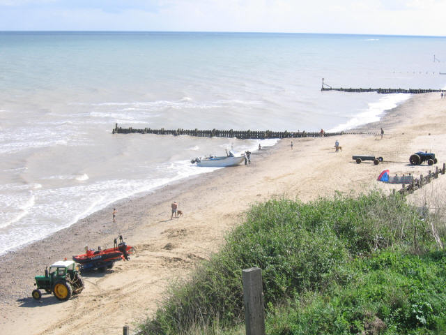 Mundesley Beach | |
 Mundesley Location within Norfolk | |
| Area | 2.84 km2 (1.10 sq mi) |
| Population | 2,758 (parish, 2011 census) |
| • Density | 971/km2 (2,510/sq mi) |
| OS grid reference | TG315365 |
| • London | 136 miles (219 km) |
| Civil parish |
|
| District | |
| Shire county | |
| Region | |
| Country | England |
| Sovereign state | United Kingdom |
| Post town | NORWICH |
| Postcode district | NR11 |
| Dialling code | 01263 |
| Police | Norfolk |
| Fire | Norfolk |
| Ambulance | East of England |
| UK Parliament | |
History
The villages name means 'Mul's/Mundel's wood/clearing'.[6]
Mundesley has an entry in the Domesday Book of 1086,[7] with the town's name recorded as Muleslai. The main landholder was William de Warenne, and the survey also lists a church.
Second World War
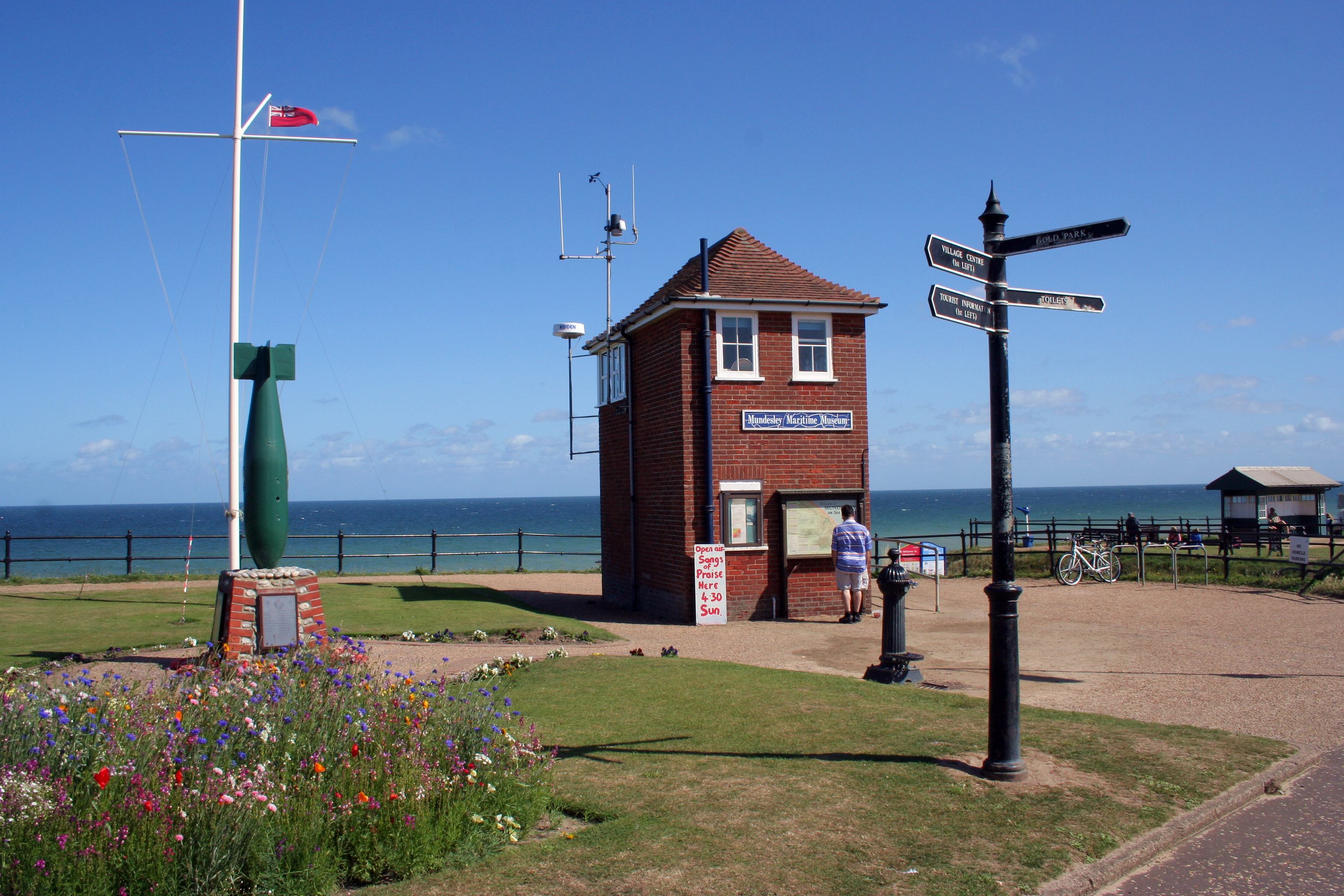
The Mundesley memorial(Bomb) is dedicated to Army teams who removed mines after the Second World War. There is a War memorial inside the Church and on the seafront at the Coastwatch station and museum. Near to the church is a World War II gun emplacement, which now stands near the edge of the cliff, due to coastal erosion.
Governance
An electoral ward in the same name exists. This ward includes Bacton and had had total population at the 2011 Census of 4,191.[8]
Tourism

Mundesley is a popular seaside holiday destination due to its sandy beaches and has a number of holiday chalet and caravan parks and hotels. Just to the south of Mundesley on the road to Paston is a popular windmill, Stow Mill. The village was a popular seaside resort in Victorian times, benefiting from its own railway station which closed in 1964.
Golf course
The village has an historic golf course in the Mun Valley, designed with the help of six-times Open Champion Harry Vardon. Vardon convalesced at the nearby sanitorium while recovering from tuberculosis and his association with the course spanned many years. It is said that he scored his only hole-in-one on what is now the sixth. The course was reduced to nine holes when land was required for wartime farming, which was very important in that era.
Village amenities
Parish church
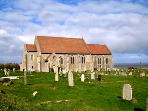
All Saints' Church is located on the cliffs above the sea. It was fully restored between 1904 and 1914.[citation needed]
Village centre
The village centre offers shops including a butchers, clothing, arts and crafts, chemist and convenience stores. Mundesley also has its own medical centre and primary school. There is an adventure island crazy golf park close to the seafront. There is a very small maritime museum which is also the local lookout of the National Coastwatch Institution, a charity offering 365 days' lookout in over 50 stations along the British coast.
Public houses and hotels
There are two pubs in Mundesley. One of the oldest is the Ship Inn situated on the sea front. Its first landlord is listed as being Paul Harrison in 1836. Its flint construction is characteristic of the older parts of the village. A little inland, on the road to Paston, is the Royal Hotel, where Lord Nelson is said to have lived for a while. Plentiful lodging is available. The Link's and Seaward Crest chalet parks are very close and are very popular.
Notable residents
- Ian Thornton OBE - Chief Executive Officer of the Norwich City Community Sports Foundation
See also
- Mundesley Volunteer Inshore Lifeboat
References
- Ordnance Survey, Explorer Sheet 252, Norfolk Coast East, ISBN 978-0-319-46726-8
- County A to Z Atlas, Street & Road maps Norfolk, Map page 229, ISBN 978-1-84348-614-5
- County A to Z Atlas, Street & Road maps Norfolk, page 230 ISBN 978-1-84348-614-5
- "Parish population 2011". Retrieved 1 September 2015.
- "Mundesley named best beach in North Norfolk in Battle of the Beaches 2022". Retrieved 5 September 2022.
- "Key to English Place-names".
- The Domesday Book, Englands Heritage, Then and Now, Editor: Thomas Hinde, Norfolk page 186, Mundesley, ISBN 1-85833-440-3
- "Ward population 2011". Retrieved 1 September 2015.
External links
- Coastwatch Mundesley
- Mundesley Maritime Museum
- Live Weather in Mundesley
- Mundesley on Sea Parish Council
- Mundesley Photo Gallery
- Mundesley village website
- Mundesley Free Church
| Authority control |
|
|---|
Другой контент может иметь иную лицензию. Перед использованием материалов сайта WikiSort.org внимательно изучите правила лицензирования конкретных элементов наполнения сайта.
WikiSort.org - проект по пересортировке и дополнению контента Википедии