geo.wikisort.org - Coast
Dodman Point (Cornish: Penn Den Varow) near Mevagissey is the highest headland on the south Cornwall coast, measuring 374 feet (114 m).[3] It is also known by its earlier names of the Deadman and Deadman's Point.[4] It hosts the remains of an Iron Age promontory fort,[2] and at its seaward end is "Parson Martin's Cross" – a large granite cross[5] erected in 1896 to encourage those involved in Christian service,[6] and which aids navigation around the headland.[3] Dodman Point is mentioned in the shanty Spanish Ladies.
Dodman Point | |
|---|---|
 Dodman Point from the south west | |
 Dodman Point | |
| Coordinates: 50°13′10″N 4°48′07″W | |
| Location | Cornwall |
| Operator | National Trust |
| Elevation | 113.96 m (373.88 ft) |
| Designation | Scheduled monument[2] |
| Website | www |
To its north-east and in its lee is the small anchorage and sand beach of Gorran Haven.
Below the large stone cross, there is a way down to the bottom of the small cliffs and there is some climbing there on the faces – mainly bouldering as it is rarely scaled so there are no fixed anchor points.[7]
Gallery
 Viewed from the east
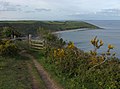 Viewed from the west
 Parson Martin's Cross
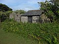 The Watch House
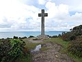 Parson Martin's Cross


References
- Ordnance Survey Bench Mark height via "The National Heritage List for England | English Heritage". Archived from the original on 24 April 2012. Retrieved 17 September 2011.
- Historic England. "Details from listed building database (1020865)". National Heritage List for England. Retrieved 28 September 2015.
- "The Dodman".
- McKenzie & al. The New British Channel Pilot, containing Sailing Directions from London to Liverpool, including the Bristol Channel, and from Calais to Brest; also for the Coasts of Ireland, from Loch Carlingford to London, and thence to Galway Bay; compiled from the Latest Surveys of the Coasts of England and Ireland, also of the Coasts and Harbours of France, including the Remarks and Observations of Several Pilots, Masters in the Navy, and Coasters (11th ed.), p. 66. J.W. Norie & Co. (London), 1839. Accessed 26 May 2014.
- "MNA102053 | National Trust Heritage Records".
- "PARSON MARTin's CROSS, St. Goran - 1144778 | Historic England".
- "UK Climbing Limited". Dodman Point.
Cornwall Portal | |
| Unitary authorities |
|
| Major settlements |
|
| Rivers | |
| Topics |
|
Другой контент может иметь иную лицензию. Перед использованием материалов сайта WikiSort.org внимательно изучите правила лицензирования конкретных элементов наполнения сайта.
WikiSort.org - проект по пересортировке и дополнению контента Википедии