geo.wikisort.org - Coast
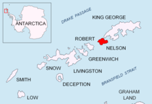
Cariz Point (Agrelo Point) is the rocky north extremity of Nelson Island in the South Shetland Islands, Antarctica. It forms the east entrance point of Quesada Cove and is located at 62°13′57″S 59°03′00″W, which is 2.5 km northeast of Meana Point, 3.7 km west-northwest of Rip Point, and 1.7 km southwest of Exotic Point on King George Island. British mapping of the area in 1968.
Maps
- Livingston Island to King George Island. Scale 1:200000. Admiralty Nautical Chart 1776. Taunton: UK Hydrographic Office, 1968
- South Shetland Islands. Scale 1:200000 topographic map No. 3373. DOS 610 - W 62 58. Tolworth, UK, 1968
- Antarctic Digital Database (ADD). Scale 1:250000 topographic map of Antarctica. Scientific Committee on Antarctic Research (SCAR). Since 1993, regularly upgraded and updated
References
- Cabo Cariz. Composite Antarctic Gazetteer
- Cabo Agrelo. Composite Antarctic Gazetteer
External links
- Cariz (Agrelo) Point. Copernix satellite image
This Nelson Island, South Shetlands location article is a stub. You can help Wikipedia by expanding it. |
На других языках
[de] Cariz Point
Der Cariz Point (englisch; in Chile Cabo Cariz, in Argentinien Cabo Agrelo) ist eine Landspitze an der Nordwestküste von Nelson Island im Archipel der Südlichen Shetlandinseln. Sie markiert die westlichen Begrenzung der Einfahrt von der Drakestraße in die Fildes Strait.- [en] Cariz Point
Текст в блоке "Читать" взят с сайта "Википедия" и доступен по лицензии Creative Commons Attribution-ShareAlike; в отдельных случаях могут действовать дополнительные условия.
Другой контент может иметь иную лицензию. Перед использованием материалов сайта WikiSort.org внимательно изучите правила лицензирования конкретных элементов наполнения сайта.
Другой контент может иметь иную лицензию. Перед использованием материалов сайта WikiSort.org внимательно изучите правила лицензирования конкретных элементов наполнения сайта.
2019-2026
WikiSort.org - проект по пересортировке и дополнению контента Википедии
WikiSort.org - проект по пересортировке и дополнению контента Википедии