geo.wikisort.org - Coast
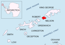
Rip Point (62°15′S 58°59′W) is a point on Nelson Island forming the south side of the east entrance to Fildes Strait, in the South Shetland Islands. The name appears on a British Admiralty chart showing the results of a survey by DI personnel on the Discovery II in 1935.
References
![]() This article incorporates public domain material from the United States Geological Survey document: "Rip Point". (content from the Geographic Names Information System)
This article incorporates public domain material from the United States Geological Survey document: "Rip Point". (content from the Geographic Names Information System)
This Nelson Island, South Shetlands location article is a stub. You can help Wikipedia by expanding it. |
На других языках
[de] Rip Point
Der Rip Point (englisch für Brandungsspitze) ist eine Landspitze von Nelson Island im Archipel der Südlichen Shetlandinseln. Sie bildet die Südseite der östlichen Einfahrt zur Fildes Strait.- [en] Rip Point
Текст в блоке "Читать" взят с сайта "Википедия" и доступен по лицензии Creative Commons Attribution-ShareAlike; в отдельных случаях могут действовать дополнительные условия.
Другой контент может иметь иную лицензию. Перед использованием материалов сайта WikiSort.org внимательно изучите правила лицензирования конкретных элементов наполнения сайта.
Другой контент может иметь иную лицензию. Перед использованием материалов сайта WikiSort.org внимательно изучите правила лицензирования конкретных элементов наполнения сайта.
2019-2026
WikiSort.org - проект по пересортировке и дополнению контента Википедии
WikiSort.org - проект по пересортировке и дополнению контента Википедии