geo.wikisort.org - Coast
Cape Lookout is the southern point of the Core Banks, one of the natural barrier islands on the Atlantic coast of North Carolina. It delimits Onslow Bay to the west from Raleigh Bay to the east. Core Banks and Shackleford Banks have been designated as parts of the Cape Lookout National Seashore.[1]
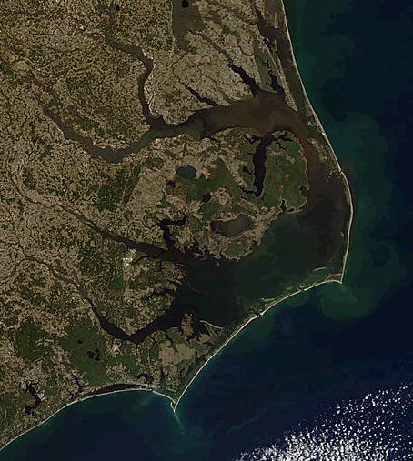
Part of Carteret County, the cape sits 11 miles southeast of Beaufort. It is one of the state's three major capes, along with Cape Hatteras to the north and Cape Fear to the south.
The 163-foot[2] Cape Lookout Lighthouse sits about three miles northeast of the cape's point.[3]
Climate
According to the Trewartha climate classification system, Cape Lookout, North Carolina has a humid subtropical climate with hot and humid summers, cool winters and year-around precipitation (Cfak). Cfak climates are characterized by all months having an average mean temperature > 32.0 °F (> 0.0 °C), at least eight months with an average mean temperature ≥ 50.0 °F (≥ 10.0 °C), at least one month with an average mean temperature ≥ 71.6 °F (≥ 22.0 °C) and no significant precipitation difference between seasons. During the summer months in Cape Lookout, a cooling afternoon sea breeze is present on most days, but episodes of extreme heat and humidity can occur with heat index values ≥ 100 °F (≥ 38 °C). Cape Lookout is prone to hurricane strikes, particularly during the Atlantic hurricane season which extends from June 1 through November 30, sharply peaking from late August through September. During the winter months, episodes of cold and wind can occur with wind chill values < 10 °F (< -12 °C). The plant hardiness zone in Cape Lookout is 8b with an average annual extreme minimum air temperature of 14.6 °F (-9.7 °C).[4] The average seasonal (Dec-Mar) snowfall total is < 2 inches (< 5 cm), and the average annual peak in nor'easter activity is in February.
| Climate data for Cape Lookout, NC (1981-2010 Averages) | |||||||||||||
|---|---|---|---|---|---|---|---|---|---|---|---|---|---|
| Month | Jan | Feb | Mar | Apr | May | Jun | Jul | Aug | Sep | Oct | Nov | Dec | Year |
| Average high °F (°C) | 52.6 (11.4) |
54.1 (12.3) |
59.0 (15.0) |
65.8 (18.8) |
72.8 (22.7) |
80.0 (26.7) |
83.1 (28.4) |
82.6 (28.1) |
79.3 (26.3) |
71.6 (22.0) |
64.2 (17.9) |
56.0 (13.3) |
68.5 (20.3) |
| Daily mean °F (°C) | 46.4 (8.0) |
48.0 (8.9) |
53.2 (11.8) |
60.6 (15.9) |
68.1 (20.1) |
76.0 (24.4) |
79.5 (26.4) |
78.8 (26.0) |
75.0 (23.9) |
66.1 (18.9) |
57.9 (14.4) |
49.7 (9.8) |
63.3 (17.4) |
| Average low °F (°C) | 40.1 (4.5) |
41.8 (5.4) |
47.3 (8.5) |
55.4 (13.0) |
63.4 (17.4) |
71.9 (22.2) |
75.9 (24.4) |
75.0 (23.9) |
70.8 (21.6) |
60.5 (15.8) |
51.6 (10.9) |
43.4 (6.3) |
58.2 (14.6) |
| Average precipitation inches (mm) | 4.52 (115) |
3.71 (94) |
4.42 (112) |
3.31 (84) |
4.27 (108) |
4.52 (115) |
6.02 (153) |
7.26 (184) |
6.71 (170) |
4.48 (114) |
4.05 (103) |
4.01 (102) |
57.28 (1,455) |
| Average relative humidity (%) | 74.7 | 75.1 | 74.5 | 74.9 | 76.7 | 79.0 | 82.2 | 79.7 | 78.9 | 75.1 | 77.5 | 75.9 | 77.0 |
| Average dew point °F (°C) | 38.8 (3.8) |
40.5 (4.7) |
45.3 (7.4) |
52.6 (11.4) |
60.5 (15.8) |
69.0 (20.6) |
73.6 (23.1) |
72.0 (22.2) |
68.0 (20.0) |
58.0 (14.4) |
50.9 (10.5) |
42.4 (5.8) |
56.0 (13.3) |
| Source: PRISM[5] | |||||||||||||
| Climate data for Cape Hatteras, NC Ocean Water Temperature (72 NE Cape Lookout) | |||||||||||||
|---|---|---|---|---|---|---|---|---|---|---|---|---|---|
| Month | Jan | Feb | Mar | Apr | May | Jun | Jul | Aug | Sep | Oct | Nov | Dec | Year |
| Daily mean °F (°C) | 49 (9) |
46 (8) |
52 (11) |
59 (15) |
68 (20) |
74 (23) |
78 (26) |
80 (27) |
77 (25) |
70 (21) |
58 (14) |
55 (13) |
64 (18) |
| Source: NOAA[6] | |||||||||||||
Ecology
According to the A. W. Kuchler U.S. potential natural vegetation types, Cape Lookout, North Carolina would have a dominant vegetation type of Live oak/Sea Oats Uniola paniculata (90) with a dominant vegetation form of Coastal Prairie (20).[7]
References
- Cape Lookout National Seashore. "Current Documents". Retrieved October 22, 2011.
- "CAPE LOOKOUT". www.outerbankslighthousesociety.org. Retrieved 2020-07-26.
- "Maps - Cape Lookout National Seashore (U.S. National Park Service)". www.nps.gov. Retrieved 2020-07-26.
- "USDA Interactive Plant Hardiness Map". United States Department of Agriculture. Retrieved August 6, 2019.
- "PRISM Climate Group, Oregon State University". Retrieved August 6, 2019.
- "Water Temperature Table of All Coastal Regions". Archived from the original on September 5, 2017. Retrieved August 6, 2019.
- "U.S. Potential Natural Vegetation, Original Kuchler Types, v2.0 (Spatially Adjusted to Correct Geometric Distortions)". Retrieved August 6, 2019.
Authority control | |
|---|---|
| National libraries | |
| Other | |
На других языках
- [en] Cape Lookout (North Carolina)
[ru] Лукаут (мыс, Северная Каролина)
Мыс Лукаут (или Мыс Наблюдения) — самая южная точка барьерных островов, Южных Корских отмелей, южной оконечности Внешних отмелей Атлантического побережья Северной Каролины (США). Мыс Лукаут разделяет залив Онслоу на юго-западе от залива Роли на востоке. Местность по обе стороны от отмелей относится к Национальному парку «Мыс Лукаут».Другой контент может иметь иную лицензию. Перед использованием материалов сайта WikiSort.org внимательно изучите правила лицензирования конкретных элементов наполнения сайта.
WikiSort.org - проект по пересортировке и дополнению контента Википедии