geo.wikisort.org - Coast
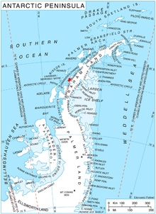
Cape Bellue is a headland on the north side of the entrance to Darbel Bay, which forms the west extremity of Stresher Peninsula on the west coast of Graham Land, Antarctica. It separates Graham Coast to the northeast from Loubet Coast to the southwest. Discovered by the French Antarctic Expedition, 1908–10, under Charcot, and named by him for Admiral Bellue, Superintendent of the Dockyard at Cherbourg, France. The cape was roughly mapped by BGLE in August-September 1935 and called in error "Cape Evensen". The cape was photographed from the air by FIDASE and surveyed from the ground by FIDS from Detaille Island, 1956-57
External links
- Cape Bellue on USGS website
- Cape Bellue on AADC website
- Cape Bellue on SCAR website
References
![]() This article incorporates public domain material from the United States Geological Survey document: "Cape Bellue". (content from the Geographic Names Information System)
This article incorporates public domain material from the United States Geological Survey document: "Cape Bellue". (content from the Geographic Names Information System)
This Loubet Coast location article is a stub. You can help Wikipedia by expanding it. |
На других языках
[de] Kap Bellue
Das Kap Bellue ist ein Kap, welches das Nordende der Einfahrt zur Darbel Bay an der Westküste des antarktischen Grahamlandes markiert. Ebenso markiert es den Grenzpunkt zwischen der Graham-Küste im Norden und der Loubet-Küste im Süden.- [en] Cape Bellue
Другой контент может иметь иную лицензию. Перед использованием материалов сайта WikiSort.org внимательно изучите правила лицензирования конкретных элементов наполнения сайта.
WikiSort.org - проект по пересортировке и дополнению контента Википедии