geo.wikisort.org - Coast
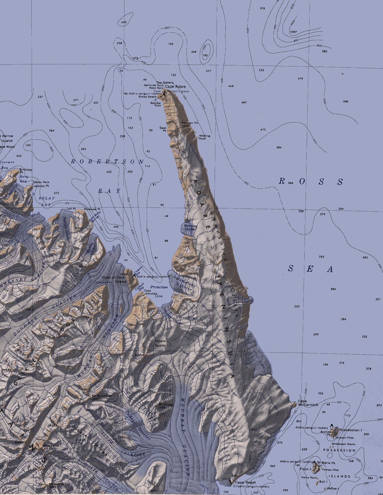
The Adare Peninsula, sometimes called the Cape Adare Peninsula, is a high ice-covered peninsula, 40 miles (64 km) long, in the northeast part of Victoria Land, extending south from Cape Adare to Cape Roget. The peninsula is considered the southernmost point of the Borchgrevink Coast, named for Carsten Borchgrevink (1864-1934). The peninsula was named by the New Zealand Antarctic Place-Names Committee (NZ-APC) for Cape Adare.[1]
| Adare Peninsula | |
|---|---|
 Adare Peninsula | |
| Highest point | |
| Coordinates | 71°40′S 170°30′E |
| Geography | |
 Adare Peninsula Victoria Land, Antarctica | |
| Geology | |
| Mountain type | Shield volcanoes |
The Adare Peninsula consists of overlapping shield volcanoes that have been potassium–argon dated 6 to 13 million years old. Potassium–argon dates of 2.27 million years and perhaps 1.14 million years have also been obtained.[2] The Adare Peninsula shields form part of the Hallett Volcanic Province of the McMurdo Volcanic Group.[3]
Named features
West coast
Cape Adare is a prominent cape of black basalt forming the northern tip of the Adare Peninsula and the north-easternmost extremity of Victoria Land.[4]
On the west side of the peninsula is Ridley Beach, a cupsate beach forming a triangle about 1 nautical mile (1.9 km; 1.2 mi) long on each side, lying 1 nmi (1.9 km; 1.2 mi) south of Cape Adare. This was the camp site of the British Antarctic Expedition, 1898–1900, under C.E. Borchgrevink, who gave the camp his mother's maiden name. The Northern Party of the British Antarctic Expedition of 1910–13 disembarked here in 1911, and they gave the name "Ridley" to the entire beach. The beach is the site of an Adelie penguin rookery.[5] The very west point of the beach is called Von Tunzelman Point. It was named in 1984 by NZAPC after Alexander von Tunzelman, a member of the first recorded landing in Victoria Land in 1895.[6]
Immediately south of the beach is Boulder Rock, a large offshore rock first charted and named in 1911 by the Northern Party of the British Antarctic Expedition, 1910–13, led by Victor Campbell.[7] 3.5 nmi (6.5 km; 4.0 mi) south is Seal Point, charted and named in 1911 by the Northern Party.[8]
Inland to the south, the peninsula is bordered by the Admiralty Mountains. The Adare Saddle is located where the mountains meet the peninsula.[9]
East coast
Unless otherwise noted, the following features on the peninsula's east coast were discovered and named by Captain James Clark Ross in 1841.
Much of the east side of the peninsula is a line of precipitous basalt cliffs rising to 2,000 metres (6,600 ft), known as the Downshire Cliffs. Captain Ross applied the name "Cape Downshire" to a part of these cliffs at the request of Commander Francis R.M. Crozier of HMS Downshire. No prominent cape exists here but for the sake of historical continuity, the name has been reapplied to these cliffs.[10] Nestling Rock lies in the sea just south of the north portion of Adare Peninsula. The descriptive name applied by NZ-APC suggests the location of this relatively small feature beside the towering Downshire Cliffs.[11]
Fenwick Ice Piedmont is an ice piedmont on the east side of Adare Peninsula, formed by numerous glaciers draining the east side of the peninsula between the Downshire Cliffs and Cape McCormick. It was named by NZ-APC in 2005 to honor the lengthy service given by Rob Fenwick to furthering the protection of historic sites under New Zealand's care in Antarctica.[12] Farther to the south, Cape McCormick marks the eastern extremity of Adare Peninsula. Ross named it for Robert McCormick, surgeon on HMS Erebus.[13]
Cape Roget is a steep rock cape at the south tip of the east coast of Adare Peninsula, marking the north side of the entrance to Moubray Bay. It was named for Peter Mark Roget, noted English lexicographer. The cape is the site of an Emperor penguin rookery.[14]
See also
References
- "Adare Peninsula". Geographic Names Information System. United States Geological Survey, United States Department of the Interior. Retrieved 18 April 2020.
- "Adare Peninsula". Global Volcanism Program. Smithsonian Institution. Retrieved 14 September 2016.
- Riffenburgh, Beau (2007). Encyclopedia of the Antarctic. Vol. 1. Taylor & Francis. p. 639. ISBN 0-415-97024-5.
- "Cape Adare". Geographic Names Information System. United States Geological Survey. Retrieved 18 April 2020.
- "Ridley Beach". Geographic Names Information System. United States Geological Survey. Retrieved 18 April 2020.
- "Von Tunzelman Point". Geographic Names Information System. United States Geological Survey. Retrieved 18 April 2020.
- "Boulder Rock". Geographic Names Information System. United States Geological Survey. Retrieved 18 April 2020.
- "Seal Point". Geographic Names Information System. United States Geological Survey. Retrieved 18 April 2020.
- "Adare Saddle". Geographic Names Information System. United States Geological Survey. Retrieved 18 April 2020.
- "Downshire Cliffs". Geographic Names Information System. United States Geological Survey. Retrieved 18 April 2020.
- "Nestling Rock". Geographic Names Information System. United States Geological Survey. Retrieved 18 April 2020.
- "Fenwick Ice Piedmont". Geographic Names Information System. United States Geological Survey. Retrieved 18 April 2020.
- "Cape McCormick". Geographic Names Information System. United States Geological Survey. Retrieved 18 April 2020.
- "Cape Roget". Geographic Names Information System. United States Geological Survey. Retrieved 18 April 2020.
![]() This article incorporates public domain material from websites or documents of the United States Geological Survey.
This article incorporates public domain material from websites or documents of the United States Geological Survey.
На других языках
[de] Adare-Halbinsel
Die Adare-Halbinsel ist eine bis zu 2083 m hoch aufragende, vereiste und knapp 80 km lange Halbinsel im Nordosten des ostantarktischen Viktorialands. Sie liegt zwischen der westlich gelegenen Somow-See und dem Rossmeer im Osten. Sie reicht vom Kap Roget im Süden bis zum Kap Adare an der Nordspitze der Halbinsel. An ihrer Westflanke liegt die Robertson Bay.- [en] Adare Peninsula
Другой контент может иметь иную лицензию. Перед использованием материалов сайта WikiSort.org внимательно изучите правила лицензирования конкретных элементов наполнения сайта.
WikiSort.org - проект по пересортировке и дополнению контента Википедии