geo.wikisort.org - Küste
| Scott-Küste | ||
|---|---|---|
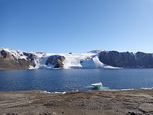
 Tethys Bay im nördlichen Küstenabschnitt unweit des Kap Washington | ||
| Lage | Viktorialand, Ostantarktika | |
| Gewässer | Rossmeer | |
| Von | Kap Washington 74° 39′ 0″ S, 165° 25′ 0″ O | |
| Bis | Minna Bluff 78° 34′ 30″ S, 167° 4′ 20″ O | |
 | ||
Die Scott-Küste ist ein Küstenabschnitt entlang des McMurdo-Sunds im ostantarktischen Viktorialand, der sich zwischen Kap Washington im Norden und dem Minna Bluff im Süden erstreckt. Im Norden schließt sich die Borchgrevink-Küste an, und im Süden die Hillary-Küste. Sie liegt weitgehend am offenen Rossmeer, reicht aber im Süden in das Ross-Schelfeis hinein.
Das New Zealand Antarctic Place-Names Committee benannte die Küste nach dem britischen Polarforscher Robert Falcon Scott (1868–1912), Leiter der Discovery-Expedition (1901–1904) und der Terra-Nova-Expedition (1911–1913), unter dessen Führung der größte Teil dieser Küste erkundet und zahlreiche geographische Objekte benannt wurden.
Weblinks
- Scott Coast im Geographic Names Information System des United States Geological Survey (englisch)
- Scott Coast auf geographic.org (englisch)
На других языках
- [de] Scott-Küste
[en] Scott Coast
Scott Coast (.mw-parser-output .geo-default,.mw-parser-output .geo-dms,.mw-parser-output .geo-dec{display:inline}.mw-parser-output .geo-nondefault,.mw-parser-output .geo-multi-punct{display:none}.mw-parser-output .longitude,.mw-parser-output .latitude{white-space:nowrap}76°30′S 162°30′E) is the portion of the coast of Victoria Land between Cape Washington and Minna Bluff. Named by New Zealand Antarctic Place-Names Committee (NZ-APC) in 1961 after Captain Robert Falcon Scott, Royal Navy, leader of the Discovery expedition (1901–1904) and the British Antarctic Expedition (1910-1913), who lost his life on the return journey from the South Pole. Much of the early exploration of this coastline was accomplished by Scott and his colleagues, and many of the names in the region were bestowed by him.[it] Costa di Scott
La costa di Scott (.mw-parser-output .geo-default,.mw-parser-output .geo-dms,.mw-parser-output .geo-dec{display:inline}.mw-parser-output .geo-nondefault,.mw-parser-output .geo-multi-punct{display:none}.mw-parser-output .latitude,.mw-parser-output .longitude{white-space:nowrap}.mw-parser-output .geo{}body.skin-vector .mw-parser-output #coordinates{font-size:85%;line-height:1.5em;position:absolute;right:0;top:0;white-space:nowrap}76°30′S 162°30′E) è una porzione della costa della Terra della Regina Vittoria, in Antartide. In particolare, la costa di Scott si estende tra la scogliera Minna (78°31′S 166°25′E), un promontorio roccioso alla bocca della baia di Moore, a sud, e capo Washington (74°39′S 165°25′E), che separa la baia Terra Nova e la baia di Wood, a nord, e confina a sud con la costa di Hillary e a nord con la costa di Borchgrevink.[1]Текст в блоке "Читать" взят с сайта "Википедия" и доступен по лицензии Creative Commons Attribution-ShareAlike; в отдельных случаях могут действовать дополнительные условия.
Другой контент может иметь иную лицензию. Перед использованием материалов сайта WikiSort.org внимательно изучите правила лицензирования конкретных элементов наполнения сайта.
Другой контент может иметь иную лицензию. Перед использованием материалов сайта WikiSort.org внимательно изучите правила лицензирования конкретных элементов наполнения сайта.
2019-2025
WikiSort.org - проект по пересортировке и дополнению контента Википедии
WikiSort.org - проект по пересортировке и дополнению контента Википедии
