geo.wikisort.org - Küste
Die Fallières-Küste ist der an der Marguerite-Bucht liegende Teil der Westküste des Grahamlands auf der Antarktischen Halbinsel. Die Küste reicht vom Eingang des Bourgeois-Fjords bis zum Kap Jeremy am Beginn des George-VI-Sunds. Im Norden schließt sich die Loubet-Küste an und im Süden die Rymill-Küste.
| Fallières-Küste | ||
|---|---|---|
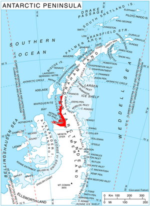 Lage der Fallières-Küste auf der Antarktischen Halbinsel | ||
| ||
| Lage | Grahamland, Antarktische Halbinsel | |
| Gewässer | Marguerite Bay, Bellingshausensee | |
| Von | Bourgeois-Fjord 67° 37′ 40,8″ S, 66° 59′ 47″ W | |
| Bis | Kap Jeremy 69° 24′ 9″ S, 68° 50′ 17,9″ W | |

Ihr nördlicher Teil wurde am 15. Januar 1909 von der französischen Antarktisexpedition 1908–1910 entdeckt und kartiert, deren Leiter Jean-Baptiste Charcot den Landstrich nach dem französischen Präsidenten Armand Fallières benannte. Im südlichen Sommer 1936/37 wurde die Küstenlinie vollständig von der British Grahamland Expedition unter Leitung von John Rymill vermessen.[1]
Weblinks
- Fallières Coast im Geographic Names Information System des United States Geological Survey (englisch)
- Fallières Coast auf geographic.org (englisch)
Einzelnachweise
- John Stewart: Antarctica – An Encyclopedia. Bd. 1, McFarland & Co., Jefferson und London 2011, ISBN 978-0-7864-3590-6, S. 536 (englisch)
На других языках
- [de] Fallières-Küste
[en] Fallières Coast
The Fallières Coast is that portion of the west coast of the Antarctic Peninsula between the head of Bourgeois Fjord and Cape Jeremy and lies on Marguerite Bay and the Wordie Ice Shelf. On the south it is joined by Rymill Coast, and in the north by Loubet Coast. Fallières Coast was first explored in January 1909 by the French Antarctic Expedition under J.B. Charcot, who named it for Armand Fallières, then President of France.[1][it] Costa di Fallières
La costa di Fallières (centrata alle coordinate .mw-parser-output .geo-default,.mw-parser-output .geo-dms,.mw-parser-output .geo-dec{display:inline}.mw-parser-output .geo-nondefault,.mw-parser-output .geo-multi-punct{display:none}.mw-parser-output .latitude,.mw-parser-output .longitude{white-space:nowrap}.mw-parser-output .geo{}body.skin-vector .mw-parser-output #coordinates{font-size:85%;line-height:1.5em;position:absolute;right:0;top:0;white-space:nowrap}68°30′S 67°00′W) è una porzione della costa della Terra di Graham, in Antartide. In particolare, la costa di Fallières si estende nella parte occidentale della penisola Antartica tra il fiordo di Bourgeois, a nordest, e Capo Jeremy, a sudovest, confinando quindi a nordest con la costa di Loubet e a sudovest con la costa di Rymill (quindi con la Terra di Palmer). Davanti a parte di essa, nella parte sudorientale della baia di Marguerite, fino ad aprile 2009, data del suo completo scioglimento, era presente la piattaforma di ghiaccio Wordie.[1]Текст в блоке "Читать" взят с сайта "Википедия" и доступен по лицензии Creative Commons Attribution-ShareAlike; в отдельных случаях могут действовать дополнительные условия.
Другой контент может иметь иную лицензию. Перед использованием материалов сайта WikiSort.org внимательно изучите правила лицензирования конкретных элементов наполнения сайта.
Другой контент может иметь иную лицензию. Перед использованием материалов сайта WikiSort.org внимательно изучите правила лицензирования конкретных элементов наполнения сайта.
2019-2026
WikiSort.org - проект по пересортировке и дополнению контента Википедии
WikiSort.org - проект по пересортировке и дополнению контента Википедии