geo.wikisort.org - Küste
Die Caird-Küste ist eine Küste der Antarktis am Weddellmeer südlich des Brunt-Eisschelfs mit der Halley-Station. Sie gehört zum Coatsland, ebenso wie das südwestlich sich anschließende Prinzregent-Luitpold-Land. Im Osten schließt sich die Prinzessin-Martha-Küste im Königin-Maud-Land an.
| Caird-Küste Caird Coast, Cairdland[1] | ||
|---|---|---|
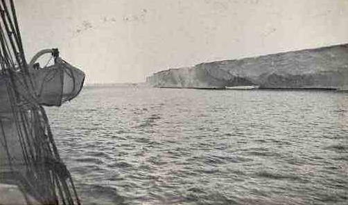 Die Klippen der Caird-Küste, aufgenommen von Frank Hurley während der Endurance-Expedition | ||
| ||
| Lage | Coatsland, Ostantarktika | |
| Gewässer | Weddell-Meer | |
| Von | Stancomb-Wills-Gletscher 75° 0′ 0″ S, 20° 0′ 0″ W | |
| Bis | Hayes-Gletscher 76° 16′ 0,1″ S, 27° 54′ 0″ W | |
 | ||

Ernest Shackleton benannte 1914 die Küste während der britischen Endurance-Expedition nach dem schottischen Unternehmer Sir James Key Caird (1837–1916), der als Hauptfinanzier diese Expedition mit £ 24.000 gesponsert hatte.
Siehe auch
- James Caird (Schiff)
Weblinks
- Caird Coast im Geographic Names Information System des United States Geological Survey
Einzelnachweise
- Bertelsmann Hausatlas. Gütersloh 1960, S. 107.
На других языках
- [de] Caird-Küste
[en] Caird Coast
The Caird Coast is the portion of the coast of Coats Land lying between the terminus of Stancomb-Wills Glacier, in 20º00´W, and the vicinity of the Hayes Glacier, in 27º54´W. Shackleton named it for Sir James Key Caird, patron of the expedition.[1][it] Costa di Caird
La costa di Caird (centrata alle coordinate .mw-parser-output .geo-default,.mw-parser-output .geo-dms,.mw-parser-output .geo-dec{display:inline}.mw-parser-output .geo-nondefault,.mw-parser-output .geo-multi-punct{display:none}.mw-parser-output .latitude,.mw-parser-output .longitude{white-space:nowrap}.mw-parser-output .geo{}body.skin-vector .mw-parser-output #coordinates{font-size:85%;line-height:1.5em;position:absolute;right:0;top:0;white-space:nowrap}76°00′S 24°00′W) è una parte della costa della Terra di Coats, in Antartide. In particolare, la costa di Caird si estende tra il fronte del ghiacciaio Stancomb-Wills (75°18′S 19°00′W), a est, e il ghiacciaio Hayes (76°16′S 27°54′W), a ovest, e confina quindi a est con la costa della Principessa Marta (e quindi con la Terra della Regina Maud) e a ovest con la costa di Luitpold, conosciuta anche come costa di Confín.Текст в блоке "Читать" взят с сайта "Википедия" и доступен по лицензии Creative Commons Attribution-ShareAlike; в отдельных случаях могут действовать дополнительные условия.
Другой контент может иметь иную лицензию. Перед использованием материалов сайта WikiSort.org внимательно изучите правила лицензирования конкретных элементов наполнения сайта.
Другой контент может иметь иную лицензию. Перед использованием материалов сайта WikiSort.org внимательно изучите правила лицензирования конкретных элементов наполнения сайта.
2019-2026
WikiSort.org - проект по пересортировке и дополнению контента Википедии
WikiSort.org - проект по пересортировке и дополнению контента Википедии