geo.wikisort.org - River
The Mohawk River is a 13.8-mile-long (22.2 km)[1] river in northern New Hampshire in the United States. It is a tributary of the Connecticut River, which flows south to Long Island Sound, an arm of the Atlantic Ocean.
| Mohawk River | |
|---|---|
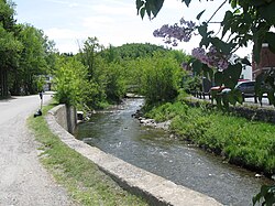
 The Mohawk River entering Colebrook | |
  | |
| Location | |
| Country | United States |
| State | New Hampshire |
| County | Coos |
| Towns | Dixville, Colebrook |
| Physical characteristics | |
| Source | Lake Gloriette |
| • location | Dixville Notch |
| • coordinates | 44°52′2″N 71°18′26″W |
| • elevation | 1,846 ft (563 m) |
| Mouth | Connecticut River |
• location | Colebrook |
• coordinates | 44°54′2″N 71°30′16″W |
• elevation | 995 ft (303 m) |
| Length | 13.8 mi (22.2 km) |
| Basin features | |
| Tributaries | |
| • left | Roaring Brook |
| • right | Moose Brook, West Branch, Read Brook, Beaver Brook |
The Mohawk River rises at the outlet of Lake Gloriette in Dixville Notch and flows west-northwest to the Connecticut River in the town of Colebrook. It is paralleled for most of its length by New Hampshire Route 26.
See also
- List of New Hampshire rivers
References
На других языках
[de] Mohawk River (New Hampshire)
Der Mohawk River ist ein etwa 24 km langer linker Nebenfluss des Connecticut River im US-Bundesstaat New Hampshire.- [en] Mohawk River (New Hampshire)
Текст в блоке "Читать" взят с сайта "Википедия" и доступен по лицензии Creative Commons Attribution-ShareAlike; в отдельных случаях могут действовать дополнительные условия.
Другой контент может иметь иную лицензию. Перед использованием материалов сайта WikiSort.org внимательно изучите правила лицензирования конкретных элементов наполнения сайта.
Другой контент может иметь иную лицензию. Перед использованием материалов сайта WikiSort.org внимательно изучите правила лицензирования конкретных элементов наполнения сайта.
2019-2025
WikiSort.org - проект по пересортировке и дополнению контента Википедии
WikiSort.org - проект по пересортировке и дополнению контента Википедии