geo.wikisort.org - River
The Johns River (also called "John's River"), in northern New Hampshire, arises at Cherry Pond in Jefferson and runs approximately 14 miles (23 km), generally northwest, to the Connecticut River.[1] It passes through Hazens Pond, near the Mount Washington Regional Airport, traverses the town of Whitefield, where it is crossed by U.S. Route 3, and then crosses the town of Dalton before joining the Connecticut. It is named for an early hunter and trapper of the area, John Glines, who established a fishing and hunting camp in the area in the 18th century. Another nearby river, the Israel River, is named for John's brother Israel.
| Johns River | |
|---|---|
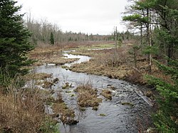
 The Johns River downstream from its source at Cherry Pond | |
  | |
| Location | |
| Country | United States |
| State | New Hampshire |
| County | Coos |
| Towns | Jefferson, Whitefield, Dalton |
| Physical characteristics | |
| Source | Cherry Pond |
| • location | Jefferson |
| • coordinates | 44°22′26″N 71°31′8″W |
| • elevation | 1,109 ft (338 m) |
| Mouth | Connecticut River |
• location | Dalton |
• coordinates | 44°25′35″N 71°40′34″W |
• elevation | 837 ft (255 m) |
| Length | 14 mi (23 km) |
| Basin features | |
| Tributaries | |
| • left | Ayling Brook, Carroll Stream, Bog Brook, Chase Brook |
The river basin drains numerous small ponds, including Martin Meadow Pond, Weeks Pond, Weed Pond, Clark Pond, Burns Pond (formerly Long Pond), Richardson Pond/Marsh, Hazens Pond, Cherry and Little Cherry Pond, Forest Lake and Mirror Lake (formerly Blake Pond). Tributaries include Chase Brook, Carroll Stream, Bear Brook, Leonard Brook, Cherry Mountain Brook, Carter Brook and Bog Brook. The watershed area is bounded by the eastern slope of the Dalton Mountain Range, the southern slope of Prospect Mountain and the western slope of Cherry Mountain (also called Mount Martha).
See also
References
На других языках
[de] Johns River (Connecticut River)
Der Johns River in New Hampshire ist ein ca. 16,5 km[1] langer Nebenfluss des Connecticut River in Coös County.[2] Er entspringt am Cherry Mountain in Jefferson. Nördlich des Berges fließt er in einer Schleife nach Norden durch den Cherry Pond und den Little Cherry Pond, dann in erst westlicher, danach zumeist nordwestlicher Richtung zum Connecticut. Der Name geht auf die Brüder John und Israel Glines zurück, die vor 1740 in der Gegend des John und des Israel River jagten und Fallen stellten.[3] Das Einzugsgebiet wird teilweise bewirtschaftet, zumeist ist es jedoch bewaldet. Neben ausgedehnten Erlenbrüchen gibt es Bestände von Espen, Birken, Kiefern und Fichten.[4] Es wird von der US 3 sowie den Staatsstraßen NH 115, 116, 135 und 142 durchquert. Oberhalb von Whitefield verläuft die Bahnstrecke Whitefield Junction–Berlin teilweise, unterhalb die Bahnstrecken Woodsville–Groveton und Portland–Island Pond entlang des Flusslaufes. Nur die letzte ist noch für Verkehr freigegeben. In Jefferson, Whitefield und Carroll liegt die Pondicherry Division der Silvio O. Conte National Fish & Wildlife Refuge, die auch das Land um Cherry, Little Cherry und Mud Pond umfasst. Hier liegen bedeutende Zugvögelhabitate. Pondicherry wurde 2004 als die erste Important Bird Area in New Hampshire ausgewiesen und ist ein National Natural Habitat.[5]- [en] Johns River (New Hampshire)
Другой контент может иметь иную лицензию. Перед использованием материалов сайта WikiSort.org внимательно изучите правила лицензирования конкретных элементов наполнения сайта.
WikiSort.org - проект по пересортировке и дополнению контента Википедии