geo.wikisort.org - Sea
Yowie Bay is a suburb in southern Sydney, in the state of New South Wales, Australia. Yowie Bay is located 24 kilometres south of the Sydney central business district, in the local government area of the Sutherland Shire.
| Yowie Bay Sydney, New South Wales | |||||||||||||||
|---|---|---|---|---|---|---|---|---|---|---|---|---|---|---|---|
 Yowie Bay marina | |||||||||||||||
Yowie Bay | |||||||||||||||
| Coordinates | 34°02′59″S 151°06′12″E | ||||||||||||||
| Population | 3,167 (2011 census)[1] | ||||||||||||||
| Established | 1889 | ||||||||||||||
| Postcode(s) | 2228 | ||||||||||||||
| Elevation | 28 m (92 ft) | ||||||||||||||
| Location | 24 km (15 mi) south of Sydney CBD | ||||||||||||||
| LGA(s) | Sutherland Shire | ||||||||||||||
| State electorate(s) | Cronulla, Miranda | ||||||||||||||
| Federal division(s) | Cook | ||||||||||||||
| |||||||||||||||
Yowie Bay takes its name from the small bay on the north shore of the Port Hacking estuary (also known locally as the Port Hacking River). It is bounded to the north by the suburb of Miranda and shares its postcode of 2228. Located to the east, across the Yowie Bay waterway, is Caringbah South. To the west is the suburb of Gymea Bay, across the bay of the same name.
History
The name for the waterway Ewey Bay first appears in an 1827 map by surveyor Robert Dixon. As Dixon had labelled other localities around Port Hacking with Aboriginal names, it is assumed that Ewey was Dixon's recording of the Aboriginal name too.
Land in the area was released as the Village of Weerona in 1889. The spelling Yowie first appears around the same time.
In an 1890 newspaper letter to the editor,[2] Richard Hill claimed the meaning of Yowie was "Cooee". Referring to Yowie Point, he claimed that there "the blacks, when travelling north, used to cooey to their friends on the north, and were brought over in the canoes..." The word "yowi" also appeared as "echo of a cooee" on a list of Aboriginal words collected in 1899 by the Anthropological Society of Australasia, in the Liverpool (police) district, which had earlier included the current Sutherland Shire area. There appears to be no relationship to the mythical Australian creature called a Yowie.
It is however unclear why both Ewey and Yowie were in use. According to one suggestion, Ewey might have been associated with ewes when sheep were run in the area in the 1860s. Some of the workers with various accents might have pronounced "ewe" as "yow" and thus introduced the pronunciation Yowie.
As reported by local newspapers,[3][4] the Sutherland Shire Council attempted to establish Ewey Bay as the correct name. However, the suburb was officially assigned the name Yowie Bay in 1973 by the Geographical Names Board.[5][6][7]
 Yowie Bay homes and jetties
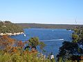 Yowie Bay view towards Port Hacking


Commercial area
Yowie Bay is a mostly residential area with just a few scattered commercial developments. A marina is located at the end of Wonga Road with a liquor shop nearby. The Port Hacking Open Sailing Club sits on Yowie Bay. The Postbox Café is on the corner of Forest Road and Attunga Road, occupying the former site of a corner shop. The Yowie Bay Friendly Grocer (formerly Yowie Bay General Store) is located on Forest Road. There is one small school, Yowie Bay Public School.
 Yowie Bay marina
 Yowie Bay marina
 Yowie Bay general store


References
- Australian Bureau of Statistics (31 October 2012). "Yowie Bay (State Suburb)". 2011 Census QuickStats. Retrieved 20 April 2015.
- "Aboriginal Names". The Sydney Morning Herald. 6 June 1890. p. 5. Retrieved 26 July 2020.
- "Post office for Ewey Bay". The Sydney Morning Herald. 18 March 1910. p. 6. Retrieved 21 April 2015.
- "Yowie or Ewey Bay". The Propeller. 27 April 1934. p. 6. Retrieved 26 July 2020.
- Burgess, Laurie (July 2020). "Sutherland Shire Origin of Suburbs". Sutherland Shire Council Spatial Services Team. p. 51f. Retrieved 12 July 2020.
- The Book of Sydney Suburbs, Compiled by Frances Pollon, Angus & Robertson Publishers, 1990, Published in Australia ISBN 0-207-14495-8, page 277
- Sutherland Shire place names Archived 18 September 2006 at the Wayback Machine
External links
На других языках
- [en] Yowie Bay, New South Wales
[ru] Йови-Бей
Йови-Бей (англ. Yowie Bay) — пригород Сиднея (штат Новый Южный Уэльс). Население по состоянию на 2006 год — 3737 человек[1]. Йови-Бей находится в 24 км южнее центрального района Сиднея, в районе местного управления Графство Сазерленд.Другой контент может иметь иную лицензию. Перед использованием материалов сайта WikiSort.org внимательно изучите правила лицензирования конкретных элементов наполнения сайта.
WikiSort.org - проект по пересортировке и дополнению контента Википедии