geo.wikisort.org - Sea
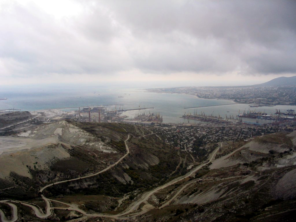
The Tsemes Bay (also Tsemess Bay and Novorossiysk Bay; Russian: Цемесская бухта, Tsemesskaya bukhta) is an ice-free bay located on the northern coast of the Black Sea, in Krasnodar Krai of Russia. It takes its name from the Tsemes River which flows into the bay. The depth of the sea varies from 21 to 27 meters. The length of the bay is 15 kilometers; its maximum width is 9 kilometers. It is delimited by the Sudzhuk Spit and by Cape Doob.
Although navigation is affected by strong autumn and winter bora winds (up to 220 kilometers per hour), ancient Greek navigators frequented the bay and established the colony of Bata on the shore. Michael Rostovtzeff explained this by the fact that there are no other decent harbours along the coastline all the way south to Batumi.[1] During the Middle Ages the Ghisolfi merchant family of Genoa controlled the coast.
Novorossiysk, founded by Russians in 1838 as a military facility, is the chief port on the bay. The Russian Navy scuttled several ships of the Black Sea Fleet in the bay to avoid their capture by the Germans in 1918. Several notable shipwrecks occurred in Tsemes bay, including that of SS Admiral Nakhimov in 1986. Following the 1992 establishment of the Caspian Pipeline Consortium, the Commercial Seaport of Novorossiysk has emerged as the busiest oil terminal in the Black Sea. The southern portion of the bay, with the minor resort of Kabardinka, is administered from Gelendzhik (see Gelendzhik Bay).
References
- Rostovtzeff, Michael Ivanovich. Iranians and Greeks in South Russia. The Clarendon Press, 1922. Page 63.
На других языках
- [en] Tsemes Bay
[ru] Цемесская бухта
Цеме́сская бухта (также Новороссийская бухта) — незамерзающая бухта в северной части российского побережья Чёрного моря. Вторая по значению бухта в российской акватории черноморского бассейна после Севастопольской бухты. В состав Российской империи бухта вошла в 1829 году, после очередной русско-турецкой войны. С тех пор активно используется для военных, торговых и пассажирских нужд региона и в первую очередь города Новороссийска. В хорошую погоду (с марта по ноябрь) подходит для стоянки кораблей всех классов. Зимой для прилегающей к бухте территории характерен довольно жёсткий ветровой режим с максимальной для СКО силой давления ветра VI-ой категории[2].Другой контент может иметь иную лицензию. Перед использованием материалов сайта WikiSort.org внимательно изучите правила лицензирования конкретных элементов наполнения сайта.
WikiSort.org - проект по пересортировке и дополнению контента Википедии