geo.wikisort.org - Sea
Gulf of İzmit (Turkish: İzmit Körfezi), also referred to as Izmit Bay, is a bay at the easternmost edge of the Sea of Marmara, in Kocaeli Province, Turkey. The gulf takes its name from the city of İzmit. Other cities and towns around the bay are Gebze, Körfez, Gölcük, and Altınova.

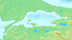
In the east–west direction, it extends for a length of about 48 kilometres (30 mi), while in the north–south direction its width varies from 2 to 3 kilometres (1.2 to 1.9 mi) at the narrowest spots to about 10 kilometres (6.2 mi) at its widest. The İzmit Bay Bridge is a suspension bridge that bridges the gulf.
Etymology
Iznik’s ancient names were Gulf of Astacus, Sinus Astacenus (Ancient Greek: Ἀστακηνὸς κόλπος),[1] Olbianus Sinus (Ancient Greek: Ὀλβιανὸς κόλπος, romanized: Olbianos kolpos)[2] and Gulf of Nicomedia.[3]
It took the names Gulf of Astacus and Sinus Astacenus from the city Astacus.[4][5]
See also
- Astacus in Bithynia
- Astacus – a genus of crayfish (from the Greek word αστακός (astakós), adopted into Turkish as ıstakoz, both meaning lobster)
- Nicomedia (modern İzmit) – the eastern and most senior capital of the Roman Empire during the Tetrarchy system
- İzmit
- İzmit Bay Bridge
- İzmit Körfez Circuit
References
External links
| Black Sea |
|
|---|---|
| Marmara | |
| Aegean | |
| Mediterranean | |
| Related geographical features |
|
| |
This Turkey-related article is a stub. You can help Wikipedia by expanding it. |
На других языках
- [en] Gulf of İzmit
[ru] Измитский залив
Измитский залив[1] (Исмитский залив[2], тур. Izmit körfezi) — узкий и длинный тектонический разлом, ныне заполненный водами Мраморного моря, в глубине которого расположен город Измит. Является частью береговой линии полуострова Малая Азия. Залив вытянут в широтном направлении, северный берег его составляет холмистый Вифинский полуостров, южный — гористый полуостров Боз и хребет Саманлы[1]. У входа в залив на южном берегу расположен город Ялова, на северном — Гебзе[1].Другой контент может иметь иную лицензию. Перед использованием материалов сайта WikiSort.org внимательно изучите правила лицензирования конкретных элементов наполнения сайта.
WikiSort.org - проект по пересортировке и дополнению контента Википедии