geo.wikisort.org - Fiume
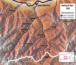
La Sill è un fiume austriaco, affluente di destra dell'Inn, che attraversa il Tirolo. Nasce ad est del passo del Brennero e scorre in direzione nord attraversando la regione della Wipptal. Sfocia nell'Inn presso Innsbruck. Ha una lunghezza di 42,2 km e un bacino di 854 km².
| Sill | |
|---|---|
 | |
| Stato | |
| Länder | |
| Lunghezza | 42,2 km |
| Bacino idrografico | 854,8 km² |
| Altitudine sorgente | 2 342 m s.l.m. |
| Altitudine foce | 565 m s.l.m. |
| Nasce | Alpi della Zillertal 46°59′28.71″N 11°32′49.93″E |
| Sfocia | Inn, presso Innsbruck 47°16′39″N 11°25′08″E |
 | |
Altri progetti
 Wikimedia Commons contiene immagini o altri file su Sill
| Controllo di autorità | VIAF (EN) 236120434 · GND (DE) 4621478-1 |
|---|
На других языках
[de] Sill
Die Sill ist ein rechter Nebenfluss des Inn in Tirol, Österreich, mit einer Länge von 42 km.[en] Sill (river)
The Sill is a 43-kilometre-long (27 mi) river in Tyrol, Austria.[1] It is one of the larger tributaries of the Inn in Tyrol. It flows north through the Wipptal to Innsbruck. Its source lies east of the Brenner Pass. At the Sillzwickel - the name of the point where it meets the Inn at Innsbruck - there is a recreation area with cycling trails.- [it] Sill
Текст в блоке "Читать" взят с сайта "Википедия" и доступен по лицензии Creative Commons Attribution-ShareAlike; в отдельных случаях могут действовать дополнительные условия.
Другой контент может иметь иную лицензию. Перед использованием материалов сайта WikiSort.org внимательно изучите правила лицензирования конкретных элементов наполнения сайта.
Другой контент может иметь иную лицензию. Перед использованием материалов сайта WikiSort.org внимательно изучите правила лицензирования конкретных элементов наполнения сайта.
2019-2026
WikiSort.org - проект по пересортировке и дополнению контента Википедии
WikiSort.org - проект по пересортировке и дополнению контента Википедии