geo.wikisort.org - Fiume
Il Mole è un fiume del sud est dell'Inghilterra.
| Mole | |
|---|---|
 | |
| Stato | |
| Regioni/aree/distretti | |
| Lunghezza | 80 km |
| Portata media | 6,64 m³/s |
| Bacino idrografico | 512 km² |
| Altitudine sorgente | 155 m s.l.m. |
| Nasce | Rusper, Horsham, West Sussex |
| Sfocia | Fiume Tamigi in località East Molesey, Elmbridge, Surrey |
 | |
Percorso
Il Mole ha origine nel West Sussex vicino all'Aeroporto di Londra-Gatwick e fluisce verso il nord-ovest attraversando la contea del Surrey per 80 km verso il fiume Tamigi per poi sfociarvi nella località di Hampton Court Palace.
Il fiume dà il nome al distretto della contea del Surrey, denominato distretto della Mole Valley.
Il Mole e i poeti
Il fiume ha catturato l'immaginazione di molti scrittori e poeti. Nell'estate del 1976 il fiume si è prosciugato nel tratto tra Dorking e Leatherhead, dove taglia attraverso la regione del Downs del Nord.[1] Infatti, nelle mappe di John Speed del Surrey del 1611, il fiume è rappresentato a fluire sottoterra, sotto una serie di colline. Il nome del fiume non deriverebbe da questo suo fluire sotterraneo (in inglese mole significa "talpa"), bensì dal latino mola (mulino) oppure una trasformazione della parola Molesey (Mul's Island). Nel Medioevo il nome del fiume era Emlyn.[2]
Galleria d'immagini
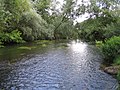 tratto della Mole
 canoe sulla Mole


Note
- River Mole at Leatherhead in 1976 photo - John Cooper photos at pbase.com
- AD Mills (1998) Oxford Dictionary of English Place Names (2nd ed.) OUP ISBN 0-19-280074-4
Altri progetti
 Wikimedia Commons contiene immagini o altri file su Mole
Collegamenti esterni
- (EN) Mole, su Enciclopedia Britannica, Encyclopædia Britannica, Inc.
На других языках
[de] River Mole (Themse)
Der River Mole ist ein Wasserlauf in England. Er entspringt im Süden von Rusper in West Sussex und fließt zunächst in östlicher Richtung. Im Norden von Crawley wendet er sich in nördliche Richtung und fließt unter dem Flughafen Gatwick hindurch nach Horley in Surrey. Der Mole durchquert die North Downs zwischen Dorking und Leatherhead im sogenannten Mole Gap, das eine Site of Special Scientific Interest (SSSI) von europäischer Bedeutung ist.[1] Der Lauf des Mole ist von Mäandern geprägt. Westlich von Thames Ditton trennt sich der Nebenarm des River Ember von ihm und bildet mit dem Hauptarm einen Ring um das Island Barn Reservoir. Der River Mole mündet gegenüber dem Hampton Court Palace in die Themse.[en] River Mole
The River Mole is a tributary of the River Thames in southern England. It rises in West Sussex near Horsham and flows northwest through Surrey for 80 km (50 miles) to the Thames at East Molesey, opposite Hampton Court Palace.[1] The river gives its name to the Surrey district of Mole Valley. The Mole crosses the North Downs between Dorking and Leatherhead, where it cuts a steep-sided valley, known as the Mole Gap, through the chalk.[2] Much of the catchment area lies on impermeable rock (including Weald Clay and London Clay), meaning that the river level responds rapidly to heavy rainfall.[2]- [it] Mole (fiume)
Другой контент может иметь иную лицензию. Перед использованием материалов сайта WikiSort.org внимательно изучите правила лицензирования конкретных элементов наполнения сайта.
WikiSort.org - проект по пересортировке и дополнению контента Википедии