geo.wikisort.org - Fiume
La Canche è un fiume francese che scorre interamente nel dipartimento di Pas-de-Calais, nella regione del Nord-Passo di Calais-Piccardia.
| Canche | |
|---|---|
 | |
| Stato | |
| Regioni | Alta Francia |
| Dipartimenti | Passo di Calais |
| Lunghezza | 100,2 km di cui 88,1 in Francia[1] |
| Portata media | 15,1 m³/s a Étaples (estuario) |
| Bacino idrografico | 1 310 km²[1] |
| Altitudine sorgente | 132 m s.l.m. |
| Nasce | Gouy-en-Ternois |
| Sfocia | nella Manica a Étaples |
Esso è lungo 100,2 km, di cui 88,1 in Francia,[1] (la differenza consiste nella diversa considerazione della Grande Tringue come affluente[2]) nasce a Gouy-en-Ternois ed attraversa il dipartimento fino alla Manica ove sfocia nei pressi di Étaples.
Non si deve confondere questa Canche con la Canche, fiume del dipartimento Saona e Loira, affluente della Celle.
Comuni attraversati
Nel solo dipartimento di Pas-de-Calais, la Canche attraversa quarantaquattro comuni[1] (da monte verso valle) :
Gouy-en-Ternois (sorgente), Magnicourt-sur-Canche, Sars-le-Bois, Berlencourt-le-Cauroy, Estrée-Wamin, Rebreuviette, Rebreuve-sur-Canche, Bouret-sur-Canche, Frévent, Ligny-sur-Canche, Boubers-sur-Canche, Monchel-sur-Canche, Conchy-sur-Canche, Aubrometz, Fillièvres, Galametz, Wail, Vieil-Hesdin, Saint-Georges, Sainte-Austreberthe, Marconne, Hesdin, Marconnelle, Huby-Saint-Leu, Guisy, Aubin-Saint-Vaast, Contes, Maresquel-Ecquemicourt, Beaurainville, Lespinoy, Marenla, Brimeux, Marles-sur-Canche, Beaumerie-Saint-Martin, Neuville-sous-Montreuil, Montreuil, La Madelaine-sous-Montreuil, La Calotterie, Attin, Beutin, Bréxent-Énocq, Saint-Josse, Tubersent, Étaples (estuario).
Affluenti
La Canche ha 14 affluenti certificati[1] di cui un effluente verso la Ternoise. I principali sono (da monte a valle):
- Riva destra
- la Ternoise (43 km) a Marconnelle
- la Planquette (12 km) a Contes
- la Créquoise (15 km) a Beaurainville
- le Bras de Brosne (11 km) a Marles-sur-Canche
- la Course (24 km) a ovest di Montreuil, tra Attin e La Madelaine-sous-Montreuil.
- la Dordogna (10 km) a Bréxent-Énocq
- l'Huitrepin (8 km) a Tubersent
- Riva sinistra
- la Grande Tringue (13 km) a Étaples[2]
Immagini della Canche
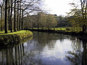 La Canche ai piedi dei bastioni di Montreuil;
 La Canche a La Madelaine-sous-Montreuil;
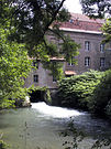 La Canche a Frévent : mulino Blondel;
 La Canche: in secondo piano il castello de La Calotterie;
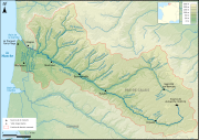 Carta de la Canche


Note
- (FR) SANDRE, Scheda del fiume Archivio (Consultato il 29 luglio 2014)
- (FR) Il SANDRE non considera la Grande Tringue come un affluente diretto della Canche.
Voci correlate
Altri progetti
 Wikimedia Commons contiene immagini o altri file su Canche
| Controllo di autorità | VIAF (EN) 315129071 · BNE (ES) XX5600397 (data) · BNF (FR) cb11963209g (data) · J9U (EN, HE) 987007529591805171 (topic) |
|---|
На других языках
[de] Canche
Die Canche (niederländisch: Kwinte) ist ein Fluss in Frankreich, der im Département Pas-de-Calais in der Region Hauts-de-France verläuft. Sie entspringt in der Landschaft Ternois, im Gemeindegebiet von Gouy-en-Ternois. Anfangs entwässert sie in südöstlicher Richtung, dreht dann aber auf Nordwest und mündet nach rund 100[3] Kilometern nördlich von Étaples und Le Touquet-Paris-Plage als Ästuar in den Ärmelkanal. Hier ist die Canche stark den Gezeiten unterworfen. Zum einen schwankt der Wasserstand des Flusses dann stark, zum anderen sind dort ausgedehnte Salzwiesen entstanden.[en] Canche
The river Canche (French pronunciation: [kɑ̃ʃ]; Dutch: Kwinte) is one of the rivers that flow from the plateau of southern Boulonnais and Picardy, into the English Channel, of which the Somme is the largest example. It is 100.2 km (62.3 mi) long.[1] The basin of the Canche extends to 1,274 square kilometres (492 sq mi) and lies in the south of the département of Pas-de-Calais. Forming an alluvial valley from 1 to 2 kilometres (0.6 to 1.2 mi) wide, the Canche valley also contains marshes, meadows and small woods. The gentle gradient, averaging 1.5 percent, gives the river a meandering course.[es] Río Canche
El río Canche es un río costero francés que recorre el occidente del departamento Paso de Calais, a lo largo de 88 km.[1] A pesar de la modesta extensión del río, el Canche se beneficia del aporte de diversos afluentes de alto caudal. Su valle ha sido testigo desde la Edad Media de un aprovechamiento del medio húmedo por parte de los seres humanos. Su estuario, típicamente picardo presenta marismas y praderas, que se ha venido tranformando y contiene una gran variedad de flora y fauna.- [it] Canche (fiume)
Другой контент может иметь иную лицензию. Перед использованием материалов сайта WikiSort.org внимательно изучите правила лицензирования конкретных элементов наполнения сайта.
WikiSort.org - проект по пересортировке и дополнению контента Википедии