geo.wikisort.org - Río
El río Kofarnihon o Kofirnihan (también transliterado del ruso como Kafirnigan) (en tayiko, Кофарниҳон) es uno de los principales afluentes del Amu Daria, junto a los ríos Vajsh y Panj.
| Río Kofarnihon (o Kafirnigan) | ||
|---|---|---|
| Кофарниҳон | ||
 | ||
| Ubicación geográfica | ||
| Cuenca | Mar de Aral | |
| Nacimiento | Cordillera Gissar | |
| Desembocadura | Río Amu Daria | |
| Coordenadas | 36°56′13″N 68°00′53″E | |
| Ubicación administrativa | ||
| País |
| |
| Cuerpo de agua | ||
| Longitud | 387 km | |
| Superficie de cuenca | 11 600 km² | |
| Caudal medio | En Tartki, 158 m³/s | |
| Mapa de localización | ||
 | ||
Geografía
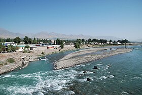
Nace en la vertiente meridional de la cordillera Gissar en el distrito de Vahdat, ex distrito Kofarnihon, recorriendo 387 km en dirección sudoeste atravesando Kofarnihon, Vahdat, y Dusambé, donde dobla hacia el sur hacia la provincia de Khatlon dirigiéndose a la frontera con Afganistán. Desemboca en Amu Daria cerca de 36 km al oeste del punto de confluencia de los ríos Vajsh y Panj.
Sus principales afluentes son los ríos Varzob y Hanaka, por la derecha, y el Ilyak, por la izquierda.
Usos
El Kofarnihon es una importante fuente de agua potable, abarcando una cuenca hidrográfica de 11.600 km². Sin embargo, está contaminado por residuos de irrigación así como por un inadecuado procesamiento de las aguas en Dusambé y Vahdat.[1] Su caudal promedio es de 156 m³/s e irriga 49.000 ha. En su curso bajo, sus riberas están cubiertas de bosques de caña y de vegetación riparia.
Tres de las diecinueve presas del país se encuentran en su curso.
Historia
Durante el período soviético se llevaron a cabo grandes obras de irrigación. Junto a Uzbekistán en 1940 Tayikistán construyó el Canal Gissar, que lleva agua del río Dusambé al Surxondaryo.
Referencias
- «Tajikistan 2002. The State of the Environment. Water Resources». Archivado desde el original el 14 de abril de 2008. Consultado el 7 de febrero de 2010.
Bibliografía
- Bookrags.com Kafirnigan River.
Enlaces externos
- Página de la FAO. El río Kofarnihon en un mapa hidrográfico de Tayikistán.
| Control de autoridades |
|
|---|
 Datos: Q2417571
 Multimedia: Kofarnihon
На других языках
[de] Kofarnihon
Kofarnihon (tadschikisch Кофарниҳон; russisch Кафирниган .mw-parser-output .Latn{font-family:"Akzidenz Grotesk","Arial","Avant Garde Gothic","Calibri","Futura","Geneva","Gill Sans","Helvetica","Lucida Grande","Lucida Sans Unicode","Lucida Grande","Stone Sans","Tahoma","Trebuchet","Univers","Verdana"}Kafirnigan) ist ein rechter Nebenfluss des Amudarja in Tadschikistan.[en] Kofarnihon
The Kofarnihon (Tajik: Кофарниҳон, Uzbek: Kofarnihon, Russian: Кафирниган Kafirnigan) is one of the major tributaries of the Amu Darya (together with Vakhsh and Panj) in Tajikistan. The river is 387 kilometres (240 mi) long and has a basin area of 11,600 square kilometres (4,500 sq mi).[1] It rises on the southern slopes of Gissar Range in Vahdat district, formerly Kofarnihon district, and flows in the general south-western direction past the cities of Vahdat and Dushanbe, where it turns south and runs through Khatlon Province toward the border with Afghanistan. It falls into Amudarya some 40 km west of the confluence point of Vakhsh and Panj rivers. The Kofarnihon is an important source of drinking water, and yet it is highly polluted by irrigation runoff and inadequately cleaned recycled water around the cities of Dushanbe and Vahdat.[2]- [es] Río Kofarnihon
[it] Kafirnigan
Il Kafirnigan o Kofarnihon (in tagiko Кофарниҳон) è un fiume del Tagikistan. È uno dei più importanti affluenti dell’Amu Darya dopo il Panj e il Vakhsh.[ru] Кафирниган
Кафирниган (тадж. Кофарниҳон; узб. Kofarnihon) — река в Средней Азии, один из главных притоков Амударьи. Протекает по Таджикистану, частично образует границу между Таджикистаном и Узбекистаном.Другой контент может иметь иную лицензию. Перед использованием материалов сайта WikiSort.org внимательно изучите правила лицензирования конкретных элементов наполнения сайта.
WikiSort.org - проект по пересортировке и дополнению контента Википедии