geo.wikisort.org - Río
El río Bani es un afluente del Níger que fluye por el este de Malí. El río confluye con el Níger cerca de la ciudad de Mopti, en la región homónima. Pasa por la ciudad de Djenné, a la que convierte en una isla cada temporada de lluvias. Tiene una longitud de 430 km. Nace por la confluencia de los ríos Baoulé y Bagoé, ambos provenientes de Costa de Marfil.
| Bani | ||
|---|---|---|
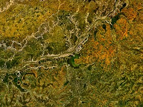 Vista satelital del río Bani | ||
| Ubicación geográfica | ||
| Cuenca | cuenca del río Níger | |
| Desembocadura | río Níger | |
| Coordenadas | 14°29′00″N 4°12′00″O | |
| Ubicación administrativa | ||
| País |
| |
| División | Región de Mopti | |
| Cuerpo de agua | ||
| Longitud | 430 km | |
| Superficie de cuenca | 101 000 km² | |
| Caudal medio | 513 m³/s | |
| Mapa de localización | ||
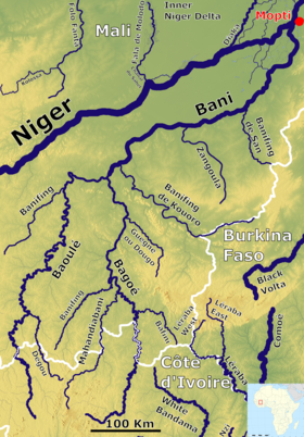 | ||
Véase también
- Sabana inundada del delta interior del Níger-Bani
Enlaces externos
 Wikimedia Commons alberga una categoría multimedia sobre Río Bani.
| Control de autoridades |
|
|---|
 Datos: Q289460
- Multimedia: Bani River
На других языках
[de] Bani (Fluss)
Der Bani ist ein Fluss in Mali.[en] Bani River
The Bani River is the principal tributary of the Niger River in Mali.[3] The river is formed from the confluence of the Baoulé and Bagoé rivers some 160 km (99 mi) east of Bamako and it merges with the Niger near Mopti. Its length is about 1,100 km (680 mi).- [es] Río Bani
[it] Bani (fiume)
Il fiume Bani è un affluente del Niger, al quale si unisce vicino Mopti, nel Mali orientale. I due fiumi formano la zona umida nota come delta interno del Niger.[ru] Бани (река)
Бани́ (фр. Le Bani) — река в Мали, правый приток Нигера.Текст в блоке "Читать" взят с сайта "Википедия" и доступен по лицензии Creative Commons Attribution-ShareAlike; в отдельных случаях могут действовать дополнительные условия.
Другой контент может иметь иную лицензию. Перед использованием материалов сайта WikiSort.org внимательно изучите правила лицензирования конкретных элементов наполнения сайта.
Другой контент может иметь иную лицензию. Перед использованием материалов сайта WikiSort.org внимательно изучите правила лицензирования конкретных элементов наполнения сайта.
2019-2026
WikiSort.org - проект по пересортировке и дополнению контента Википедии
WikiSort.org - проект по пересортировке и дополнению контента Википедии