geo.wikisort.org - Río
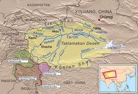
El río Hotan o Khotan o Ho-t'ien (en chino, 和田 河; pinyin, Hé Hetian) es un río que fluye al norte de la montañas Kunlun, por el desierto de Taklamakan, en el norte de China.
| Río Hotan (o Khotan) | ||
|---|---|---|
| 和田 河 - Hé Hetian | ||
 | ||
| Ubicación geográfica | ||
| Cuenca | Lop Nor (endorreica) | |
| Nacimiento | Confluencia de los ríos Yurungkash (Jade Blanco, de 513 km) y Karakash (Jade Negro, de 808 km) | |
| Desembocadura | Río Tarim | |
| Coordenadas | 40°22′00″N 80°56′00″E | |
| Ubicación administrativa | ||
| País |
| |
| División | Sinkiang | |
| Cuerpo de agua | ||
| Longitud |
incluido el Karakash, 1090 km sólo, 290 km km | |
| Superficie de cuenca | 49 000 km² | |
| Caudal medio | 142 m³/s | |
| Mapa de localización | ||
 | ||
|
| ||
El río Hotan se forma por la unión de los ríos Yurungkash (Jade Blanco, de 513 km) y Karakash (Jade Negro, de 808 km) en medio del desierto, a unos 145 kilómetros al norte de la ciudad de Khotan. El río fluye 290 kilómetros hacia el norte a través del desierto y desemboca en el río Tarim.[1] Debido a que el río es alimentado por el deshielo de las montañas, sólo lleva agua durante el verano y se seca el resto del año. El cauce del río Hotan proporciona el único sistema de transporte a través de la cuenca del Tarim.[2]
Notas
- "Khotan-Darya". Encyclopædia Britannica (1911).
- The Southwest Taklimakan Desert from NASA's Geomorphology from Space Archivado el 29 de septiembre de 2006 en Wayback Machine.. Retrieved February 26, 2006.
Referencias
- Esta obra contiene una traducción derivada de «Khotan River» de Wikipedia en inglés, publicada por sus editores bajo la Licencia de documentación libre de GNU y la Licencia Creative Commons Atribución-CompartirIgual 3.0 Unported.
| Control de autoridades |
|
|---|
 Datos: Q625575
 Multimedia: Khotan River
На других языках
[de] Hotan (Fluss)
Der Hotan (uigurisch خوتەن دەرياسى, Hoten Däryasi, chinesisch .mw-parser-output .Hani{font-size:110%}和田河, Pinyin Hétián Hé – „Fluss Hotan“) ist ein Fluss im Uigurischen Autonomen Gebiet Xinjiang in Nordwest-China.[en] Hotan River
The Hotan River (also known as the Khotan River or the Ho-t'ien River) is formed by the union of the White Jade (Yurungkash) and Karakash (Black Jade) Rivers, which flow north from the Kunlun Mountains into the Taklamakan Desert in northern China. The two rivers unite towards the middle of the desert, some 145 kilometres (90 mi) north of the town of Hotan. The river then flows 290 kilometres (180 mi) northwards across the desert and empties itself into the Tarim River.[2] Because the river is fed by melting snow from the mountains, it only carries water during the summer and is dry the rest of the year. Prior to construction of the Tarim Desert Highway in 1995, the Hotan river bed provided the only transportation system across the Tarim Basin.[3]- [es] Río Hotan
[it] Khotan (fiume)
Il fiume Khotan (o Hotan o Ho-t'ien; cinese:和田河; pinyin: Hétián hé) è formato dall'unione dello Yurungkash (fiume di giada bianca) e del Karakash (fiume di giada nera), che scorrono verso nord dai monti Kunlun entrando nel deserto di Taklamakan in Cina settentrionale. I due fiumi si uniscono al centro del deserto, circa 145 km a nord della città di Khotan. Il fiume scorre poi per 290 km a nord in mezzo al deserto gettaqndosi poi nel fiume Tarim.[1] Dato che il fiume è rifornito solo dalle nevi in scioglimento sulle montagne, trasporta acqua d'estate ed è secco nel resto dell'anno. Il letto del fiume Khotan è il solo sistema di trasporto nel bacino del Tarim.[2][ru] Хотан (река)
Хотан (кит. упр. 和田河, пиньинь Hétián hé) — река в Синьцзян-Уйгурском автономном районе Китая, в Кашгарии, правый приток Тарима. Средний расход воды по выходе из гор 120 м³/с.[1]Текст в блоке "Читать" взят с сайта "Википедия" и доступен по лицензии Creative Commons Attribution-ShareAlike; в отдельных случаях могут действовать дополнительные условия.
Другой контент может иметь иную лицензию. Перед использованием материалов сайта WikiSort.org внимательно изучите правила лицензирования конкретных элементов наполнения сайта.
Другой контент может иметь иную лицензию. Перед использованием материалов сайта WikiSort.org внимательно изучите правила лицензирования конкретных элементов наполнения сайта.
2019-2026
WikiSort.org - проект по пересортировке и дополнению контента Википедии
WikiSort.org - проект по пересортировке и дополнению контента Википедии