geo.wikisort.org - River
The Hotan River (also known as the Khotan River or the Ho-t'ien River) is formed by the union of the White Jade (Yurungkash) and Karakash (Black Jade) Rivers, which flow north from the Kunlun Mountains into the Taklamakan Desert in northern China. The two rivers unite towards the middle of the desert, some 145 kilometres (90 mi) north of the town of Hotan. The river then flows 290 kilometres (180 mi) northwards across the desert and empties itself into the Tarim River.[2] Because the river is fed by melting snow from the mountains, it only carries water during the summer and is dry the rest of the year. Prior to construction of the Tarim Desert Highway in 1995, the Hotan river bed provided the only transportation system across the Tarim Basin.[3]
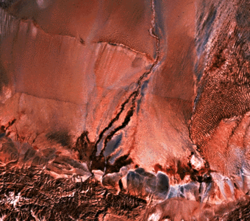
![Map including the Hotan River (labeled as Ho-tien Ho) and surrounding region (USATC, 1971)[lower-alpha 1]](http://upload.wikimedia.org/wikipedia/commons/0/00/Txu-oclc-6654394-nj-44-3rd-ed.jpg)
This article uses bare URLs, which are uninformative and vulnerable to link rot. (September 2022) |
| Hotan River | |
|---|---|
 The Hotan River is formed by the union of the White Jade and Black Jade Rivers in northern China.[1] | |
| Native name |
|
| Physical characteristics | |
| Source | Karakash River, White Jade River |
| • coordinates | 38.08°N 80.56°E |
| Mouth | Tarim River |
• coordinates | 40.478479°N 80.944169°E |
| Basin features | |
| Progression | Tarim→ Taitema Lake |
| Hotan River | |||||||||
|---|---|---|---|---|---|---|---|---|---|
| Uyghur name | |||||||||
| Uyghur | خوتەن دەرياسى | ||||||||
| |||||||||
| Chinese name | |||||||||
| Chinese | 和田河 | ||||||||
| |||||||||
| Old name | |||||||||
| Traditional Chinese | 和闐河 | ||||||||
| Simplified Chinese | 和阗河 | ||||||||
| |||||||||
Wells
In the mid-20th century, wells along the course of the river included (south to north): Hsüeh-erh-ch'i-k'o-ma, Chi-la-mu-yeh-te-tao, Ai-k'o-t'i-ken, Ch'i-erh-ko-han-t'u-mu-shu-k'o, A-ya-k'o-wu-ssu-tan, Man-ta-t'u-mu-shu-k'o, Lo-tsa-pai-t'u-mu-shu-k'o, Yeh-ma-la-k'o-tao, Po-lo-ch'u-shih-kan, Hsi-t'i-pa-ku-t'an and Ya-erh-te-ku-tzu.[4]
References
- http://www.travel-silkroad.com/english/dongfanwenming/history/htsj/gyzkc.htm
- "Khotan-Darya". 1911 Encyclopædia Britannica.
- The Southwest Taklimakan Desert Archived 2014-04-07 at the Wayback Machine from NASA's Geomorphology from Space Archived 2006-09-29 at the Wayback Machine. Retrieved March 29, 2014.
- "NJ 44 Ho-tien". Washington, D. C.: U.S. Army Topographic Command. 1971 – via Perry–Castañeda Library Map Collection.
Hsüeh-erh-ch'i-k'o-ma (well){...}Chi-la-mu-yeh-te-tao (well){...}Ai-k'o-t'i-ken (well){...}Ch'i-erh-ko-han-t'u-mu-shu-k'o (well){...}A-ya-k'o-wu-ssu-tan (well){...}Man-ta-t'u-mu-shu-k'o (well){...}Lo-tsa-pai-t'u-mu-shu-k'o (well){...}Yeh-ma-la-k'o-tao (well){...}Po-lo-ch'u-shih-kan (well){...}Hsi-t'i-pa-ku-t'an (well){...}Ya-erh-te-ku-tzu (well)
Notes
- From map: "DELINEATION OF INTERNATIONAL BOUNDARIES MUST NOT BE CONSIDERED AUTHORITATIVE".
| Authority control |
|
|---|
This Xinjiang location article is a stub. You can help Wikipedia by expanding it. |
This article related to a river in China is a stub. You can help Wikipedia by expanding it. |
На других языках
[de] Hotan (Fluss)
Der Hotan (uigurisch خوتەن دەرياسى, Hoten Däryasi, chinesisch .mw-parser-output .Hani{font-size:110%}和田河, Pinyin Hétián Hé – „Fluss Hotan“) ist ein Fluss im Uigurischen Autonomen Gebiet Xinjiang in Nordwest-China.- [en] Hotan River
[es] Río Hotan
El río Hotan o Khotan o Ho-t'ien (en chino, 和田 河; pinyin, Hé Hetian) es un río que fluye al norte de la montañas Kunlun, por el desierto de Taklamakan, en el norte de China.[it] Khotan (fiume)
Il fiume Khotan (o Hotan o Ho-t'ien; cinese:和田河; pinyin: Hétián hé) è formato dall'unione dello Yurungkash (fiume di giada bianca) e del Karakash (fiume di giada nera), che scorrono verso nord dai monti Kunlun entrando nel deserto di Taklamakan in Cina settentrionale. I due fiumi si uniscono al centro del deserto, circa 145 km a nord della città di Khotan. Il fiume scorre poi per 290 km a nord in mezzo al deserto gettaqndosi poi nel fiume Tarim.[1] Dato che il fiume è rifornito solo dalle nevi in scioglimento sulle montagne, trasporta acqua d'estate ed è secco nel resto dell'anno. Il letto del fiume Khotan è il solo sistema di trasporto nel bacino del Tarim.[2][ru] Хотан (река)
Хотан (кит. упр. 和田河, пиньинь Hétián hé) — река в Синьцзян-Уйгурском автономном районе Китая, в Кашгарии, правый приток Тарима. Средний расход воды по выходе из гор 120 м³/с.[1]Другой контент может иметь иную лицензию. Перед использованием материалов сайта WikiSort.org внимательно изучите правила лицензирования конкретных элементов наполнения сайта.
WikiSort.org - проект по пересортировке и дополнению контента Википедии