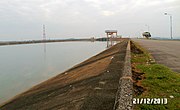
 Trị An Dam
 Near Bien Hoa
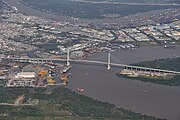 East of Ho Chi Minh City
geo.wikisort.org - River
The Đồng Nai River (Vietnamese: sông Đồng Nai ![]() listen) is a river in Vietnam that originates in the Central Highlands region of the southern portion of the country. It is approximately 586 km in length,[1] making it the longest river to be entirely located in Vietnam. It gives its name to Đồng Nai Province.
listen) is a river in Vietnam that originates in the Central Highlands region of the southern portion of the country. It is approximately 586 km in length,[1] making it the longest river to be entirely located in Vietnam. It gives its name to Đồng Nai Province.
| Dong Nai River Phước Long River | |
|---|---|
 | |
 | |
| Etymology | Nông-nại (Shallow salt-marsh) |
| Native name | Sông Đồng Nai (Vietnamese) |
| Physical characteristics | |
| Mouth | South China Sea |
• location | Cần Giờ Mangrove Forest |
• elevation | 0 m |
| Length | 568 km |
| Basin size | 38.600 km |
| Width | |
| • maximum | 2.6 km |
| Basin features | |
| Tributaries | |
| • left | Bé River, Saigon River, Vàm Cỏ |
| Waterbodies | Tri An Lake |
| Bridges | Saigon Bridge |
| Inland ports | Saigon Port |
The original Vietnamese name translated from Khmer language was Nông-nại, meaning shallow salt-marsh.
Geography
The Dong Nai River flows through the provinces of Lam Dong, Dak Nong, Binh Phuoc, Dong Nai, Binh Duong and Ho Chi Minh City with a length of over 437 km and a basin of 38,600 km², if calculated from the source of the Đa Dâng River, it is 586 km long. From the confluence with the Đa Nhim River below the Pongour waterfall, it measures 487 km. The Dong Nai River flows into the East Sea in Cần Giờ District.
The main stream of Dong Nai river in the upstream is also known as the Đa Đang river. The river originates from Lam Vien plateau , meandering along the northeast-southwest direction from the mountains to the plateau in Ta Lai (Tan Phu district, Dong Nai province). The river forms the natural boundary between Đăk R'Lấp District (Dak Nong) and Bảo Lâm District, Lâm Đồng Province, Cát Tiên District, between Cát Tiên and Bù Đăng District, Tan Phu District, Dong Nai and between Tan Phu and Đạ Tẻh District.
After meeting the Bé River, the Dong Nai River forms a natural boundary between Dong Nai on the east and Bình Dương Province on the west bank.
The river flows through Bien Hoa City, then flows along the boundary between Dong Nai and Ho Chi Minh City, between Ba Ria - Vung Tau and Ho Chi Minh City.
Hydropower
Major hydropower dams in the Dong Nai river basin:
- On the main Dong Nai river: Trị An Dam, Dong Nai 2, Dong Nai 3, Dong Nai 4, Dong Nai 5, Dong Nai 6 (in development) and Dong Nai 6A (in development).[2] The Dong Nai 6 and 6A projects are controversial as they are likely to have a significant impact on the biodiversity of Cat Tien National Park.[3]
- Bé River: Thac Mo dam, Cần Đơn dam
- Saigon River: Dau Tieng Lake
- Da Nhim River: Da Nhim dam
- Dai Ninh dam
La Nga River: Hàm Thuận – Đa Mi hydroelectric power stations
Gallery


References
- Saigon: A History Nghia M. Vo - 2011 - Page 1 "The Đồng Nai River and the much larger Mekong River had been for centuries thriving waterways that allowed easy communication and commerce with Cambodia and Laos, and the seaports of Thailand, Malaysia, Indonesia and China."
- "Trang thông tin điện tử Lâm Đồng > Tư liệu". Archived from the original on 2011-08-10. Retrieved 2019-10-01.
- "Thủy điện đe dọa sông Đồng Nai". 8 August 2011.
External links
- Diesel fuel spills into Dong Nai River, from the UNDP
- Pictures of rural homes along the Đồng Nai River
- Improving resource allocation and incomes in Vietnamese agriculture: A case study of farming in the Dong Nai River Basin, an International Food Policy Research Institute (IFPRI) discussion paper.
| Authority control |
|
|---|
На других языках
[de] Sông Đồng Nai
Der Đồng Nai (Sông Đồng Nai) ist nach dem Mekong der zweitwichtigste Fluss des südlichen Vietnams. Er entspringt im zentralen Hochland, fließt durch die Südostregion und mündet bei Ho-Chi-Minh-Stadt östlich des Mekongdeltas ins Südchinesische Meer. Mit einer Länge von 586 km ist er – bezogen nur auf den Verlauf innerhalb des Staatsgebiets – noch vor dem Roten Fluss der längste Fluss des Landes. Er wird durch Wasserkraftwerke mehrfach gestaut und spielt somit eine wichtige Rolle für die Energiegewinnung als auch für die Wasserversorgung Vietnams.[1]- [en] Đồng Nai river
[es] Río Đồng Nai
El Dong Nai (Đồng Nai en vietnamita) es un río de Vietnam que nace en la parte central del sur del país y tiene 800 km de longitud.[it] Dong Nai
Il Dong Nai (in vietnamita: Sông Đồng Nai), noto anche come Donnai, è un fiume che nasce nella regione degli Altipiani Centrali (Cordigliera Annamita) del Vietnam meridionale, a nord-ovest di Đà Lạt. Nei pressi della sorgente il fiume presenta molte rapide e viene chiamato fiume Da Dung. Scorre verso ovest e sud-ovest per circa 480 km, congiungendosi al fiume Saigon a sud-ovest di Biên Hòa. In prossimità delle rapide di Tri An, a ovest di Định Quán, è raggiunto dal fiume Be. Il Nhim, un importante affluente del suo corso superiore, nasce a nord-est di Đà Lạt, sull'altopiano di Lam Vien, e presenta tre serie di rapide e cascate. Due di queste cascate, quelle di Lien Khuong e di Gu Gau, si trovano a valle di Phi Mum; la terza, quella di Pongour, appena ad ovest della confluenza del Nhim con il Dong Nai, viene sfruttata per la produzione di energia idroelettrica. Il Dong Nai, o Donnai, dette il suo nome al Donnai Superiore (Haute Donnai), una provincia dell'Indocina francese.Текст в блоке "Читать" взят с сайта "Википедия" и доступен по лицензии Creative Commons Attribution-ShareAlike; в отдельных случаях могут действовать дополнительные условия.
Другой контент может иметь иную лицензию. Перед использованием материалов сайта WikiSort.org внимательно изучите правила лицензирования конкретных элементов наполнения сайта.
Другой контент может иметь иную лицензию. Перед использованием материалов сайта WikiSort.org внимательно изучите правила лицензирования конкретных элементов наполнения сайта.
2019-2026
WikiSort.org - проект по пересортировке и дополнению контента Википедии
WikiSort.org - проект по пересортировке и дополнению контента Википедии