geo.wikisort.org - River
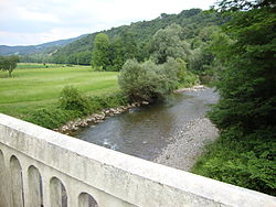
The Vert, is a left tributary of the Gave d'Oloron, that drains the Barétous in the High-Béarn (Pyrénées-Atlantiques), in the Southwest of France. It flows into the Gave d'Oloron in Moumour, downstream from Oloron-Sainte-Marie. It is 35.0 km (21.7 mi) long.[1]
| Vert | |
|---|---|
 | |
| Location | |
| Country | France |
| Physical characteristics | |
| Source | |
| • location | Barétous |
| Mouth | |
• location | Gave d'Oloron |
• coordinates | 43°13′15″N 0°39′16″W |
| Length | 35 km (22 mi) |
| Basin features | |
| Progression | Gave d'Oloron→ Gaves réunis→ Adour→ Atlantic Ocean |
Vert means 'green' in French, but the river name, Bert in 1467, is related to the Gascon word barta that means 'floodplain'.
The Vert is formed in Aramits from the confluence of:
- (R) the Vert d'Arette, Larron in 1589, from the Chousse Plateau, below the Pic de Guillers, elevation 1,597 metres (5,240 ft),
- (L) the Vert de Barlanès, from Issarbe and Lanne-en-Barétous.
References
На других языках
[de] Vert (Gave d’Oloron)
Der Vert ist ein Fluss in Frankreich, der im Département Pyrénées-Atlantiques in der Region Nouvelle-Aquitaine verläuft. Er entspringt unter dem Namen Chousse im Gemeindegebiet von Arette, entwässert generell Richtung Nordost bis Nord, ändert kurzzeitig nochmals seinen Namen auf Vert d’Arette und mündet nach rund 35[3] Kilometern im Gemeindegebiet von Moumour als linker Nebenfluss in den Gave d’Oloron.- [en] Vert (river)
[it] Vert (Barétous)
Il Vert è un fiume francese delle valli dei Pirenei, corso d'acqua principale della valle di Barétous nel dipartimento dei Pirenei Atlantici.Текст в блоке "Читать" взят с сайта "Википедия" и доступен по лицензии Creative Commons Attribution-ShareAlike; в отдельных случаях могут действовать дополнительные условия.
Другой контент может иметь иную лицензию. Перед использованием материалов сайта WikiSort.org внимательно изучите правила лицензирования конкретных элементов наполнения сайта.
Другой контент может иметь иную лицензию. Перед использованием материалов сайта WikiSort.org внимательно изучите правила лицензирования конкретных элементов наполнения сайта.
2019-2025
WikiSort.org - проект по пересортировке и дополнению контента Википедии
WikiSort.org - проект по пересортировке и дополнению контента Википедии

