geo.wikisort.org - River
Turkey Brook is a river in the northern outskirts of London. It rises in Potters Bar, Hertfordshire, and flows broadly eastwards to merge with the River Lea Navigation near Enfield Lock.


Etymology
The brook is named from the hamlet Turkey Street, which is recorded as Tokestreete (1441), Tuckhey strete (1610), Tuckey street (1615), and Turkey street (1805) (probably street of houses, i.e. hamlet, from Middle English strete, associated with a family called Toke or Tokey).
The modern form of the name Turkey, not in use before the 19th century, is no doubt due to folk etymology.[1]
Watercourse
The brook rises near the Fir and Pond Woods nature reserve in Potters Bar, and at first flows in an easterly direction. Along its course it is joined by other streams including Hollyhill Brook, Cuffley Brook, and the Small River Lea. It flows alongside the M25 motorway and Crews Hill Golf Club, then goes past Clay Hill, Whitewebbs Park, Forty Hill and Albany Park before merging with the River Lee Navigation below Enfield Lock.
Geology, origin and evolution


The main geological formation underlying the Turkey Brook catchment area[2] is Eocene London Clay. In some parts of the higher sections of the catchment area, the London Clay is overlain by "Pebble Gravel"[3] and "Dollis Hill Gravel"[4] (both Quaternary pre-glacial fluvial deposits), and by Quaternary glacial till. Downstream of where Turkey Brook goes under the M25, there are alluvium and sand and gravel deposits on the Turkey Brook valley floor. And east of Forty Hill, the brook crosses extensive Quaternary river terrace deposits laid down by the River Lea.[5][6]
As a west bank tributary of the lower River Lea, Turkey Brook came into being about 400,000 years ago, after the Anglian glaciation. During that glaciation, ice from the north of England advanced at least as far south as Watford, Finchley and Chingford.
Until the Anglian glaciation, the River Thames flowed north-eastwards via Watford, through what is now the Vale of St Albans, then eastwards towards Chelmsford and the North Sea. As a result of the glaciation, the Thames was diverted to a more southerly route, broadly along the line of its current course.[7]
Prior to the Anglian glaciation, a "proto-Mole-Wey" river was flowing northwards from the Weald and North Downs, through the "Finchley depression" and Palmers Green, to join the proto-Thames somewhere around Hoddesdon, at what is today an altitude of around 60 metres.[8] It was this river which, during the course of the early and middle Pleistocene, deposited the "Dollis Hill Gravel" at successive altitudes.
When the Anglian ice sheet diverted the Thames southwards, the Mole-Wey was cut off at Richmond.[9] Meltwater from the retreating Anglian ice sheet gave birth to a south-flowing lower River Lea, and that river cut into and followed in part the line of the former proto-Mole-Wey. It flowed into the newly diverted Thames, which at that time was spread over a wide flood plain extending as far north as Islington.[10]
And, as the ice sheet retreated, west bank tributaries of the lower Lea, such as Turkey Brook, flowed eastwards and south-eastwards from higher ground running roughly south-north through Potters Bar, down towards the newly formed lower River Lea. They, and their own tributaries, cut down successively through till left by the ice sheet, then through "Dollis Hill Gravel", and then into London Clay below.
It is not known at present whether Turkey Brook, and other west bank tributaries such as Pymmes Brook and Salmons Brook, followed valleys which had been in existence before the ice sheet covered the land, or whether they fashioned a substantially different landscape after the ice retreated. But it is known that today's tributaries of the upper Lea, such as the Rivers Mimram and Stort, follow broadly the same lines as pre-glaciation valleys, so, by analogy, it is quite possible that elements at least of the pre-glaciation topography of the lower Lea basin are reflected in today's relief.[11]

In the case of Turkey Brook immediately after the glaciation, that stream joined the River Lea somewhere around Forty Hill, where there is a deposit of "Boyn Hill Gravel".[5] That gravel, which is on the highest of the river terraces left by the post-Anglian lower River Lea, marks the line followed by the Lea after the retreat of the ice sheet.
During the course of the following 400,000 years, the lower Lea moved steadily eastwards, leaving river terrace deposits of decreasing age and altitude as it did so. Turkey Brook thus extended its course eastwards from Forty Hill, across the valley floor of the lower Lea, past Turkey Street, to where it today flows into the River Lee Navigation below Enfield Lock.

Stream pattern modification near Forty Hill
The drainage pattern in this area continues to evolve. In particular, Turkey Brook has, in the recent geological past, changed its course just after Hilly Fields. It formerly flowed south-eastwards, along what is today a "dry" channel along the south side of Forty Hill. Today, it turns northwards through Beggars Hollow to join Cuffley Brook in Whitewebbs Park. From there it continues eastwards, along the north side of Forty Hill.
At Boyn Hill time (about 400,000 years ago), Cuffley Brook and Turkey Brook joined the River Lea at points not far away from each other, north and south of where Forty Hall is today, at what is now an altitude of c50m.
Then the River Lea moved steadily towards the east. And, as a contour map shows, the two brooks each extended eastwards with the Lea, but stayed apart. The Lea and the two brooks cut down into the London Clay (to a today's altitude of c35m), thus defining the north, east and south sides of what was becoming Forty Hill.
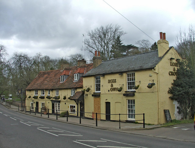
The brooks approached each other quite closely either side of Beggars Hollow (close to where, today, the Rose and Crown public house is located on Clay Hill). The dividing line between them was thus lowered by erosion at that point.
Later, the Lea moved further east to its present line, well away from Forty Hill, cutting down to a today's altitude of about 20 metres.
The low point between Turkey Brook and Cuffley Brook at Beggars Hollow was breached.[12] Turkey Brook thus changed its course, there to go north-east, through what is defined as a water gap. As a result, Turkey Brook joined Cuffley Brook in Whitewebbs Park and the merged stream continued eastwards along the former course of Cuffley Brook. But east of that junction, the stream is now known as Turkey Brook.[13]
A dry, former stream channel at c30m was left, running just north of Clay Hill, from Beggars Hollow to a point close to today's junction of Clay Hill and Baker Street. That channel now defines the southern boundary of Forty Hill.
When the New River was built, it followed the 30m contour from Hertfordshire south towards London, down the Lea valley. But, in Enfield, the engineers who constructed it took the New River on a loop going west, to the north of Forty Hill, and then across Cuffley Brook near Flash Lane (and, later, across an aqueduct[14] there). From that point, they took it south-east, through the water gap at Beggars Hollow, along the dry channel north of Clay Hill, and down to where Ladysmith Road is today. Then the New River continued on its southward course, towards Enfield Town.
The New River was later straightened to flow southwards continuously, to the east of Forty Hill. An aqueduct was built for the New River to cross Turkey Brook near Maidens Bridge. This left the former course of the New River as it is today, curling through Whitewebbs Park, passing through Beggars Hollow and following the dry channel.
 Rose and Crown Public House, Beggars Hollow, Clay Hill, Enfield (geograph.org.uk).
 The route (in blue) of the former "Whitewebbs loop" of the New River (from an information board at the Flash Lane aqueduct).
 Maiden's Bridge over Turkey Brook, at the north-east foot of Forty Hill (geograph.org.uk).


Ecology
The brook is mostly shallow, fast flowing and clean and can support wildlife. Coarse fish including dace use the brook to spawn.
Flood risk
It is estimated that, along the course of Turkey Brook, there are "an estimated 92 properties in Oakmere (Potters Bar), and 3 near Enfield Wash at risk of fluvial flooding during a 1% annual probability event".[15]
Notes and References
- Mills A. D. Oxford Dictionary of London Place Names (2001) p231 ISBN 0-19-860957-4 Retrieved 25 October 2008
- Strictly speaking, the Turkey Brook catchment area includes that of its tributary, Cuffley Brook. The two streams merge near Forty Hill. But the catchment area of Cuffley Brook itself is quite large, and is dealt with separately on the Cuffley Brook page.
- Gibbard PL (2020), London Thames Basin, page 335, in Goudie A, Migoń P (eds) Landscapes and Landforms of England and Wales
- British Geological Survey - Dollis Hill Gravel Member. See also Gibbard PL (1979), Middle Pleistocene drainage in the Thames Valley, Geological Magazine Volume 116, Issue 1 January 1979.
- See mapapps.bgs.ac.uk/geologyofbritain/ for more information on the distribution of all the formations mentioned here.
- British Geological Survey (BGS) maps at a scale of 1:50,000 which cover the Turkey Brook catchment area can be viewed online at largeimages.bgs.ac.uk/ (Hertford) and largeimages.bgs.ac.uk/ (North London).
- Bridgland, DR and Gibbard, PL (1997), Quaternary River Diversions in the London Basin and the Eastern English Channel, Géographie physique et Quaternaire, vol. 51, n° 3, 1997, pp. 337-346. Online at www.erudit.org/fr/revues/. See in particular Figure 1.
- Murton, Della K. and Murton, Julian B. (2012), Middle and Late Pleistocene glacial lakes of lowland Britain and the southern North Sea Basin. Quaternary International, Volume 260, 18 May 2012, Pages 115-142, Fig. 7A. Online at coek.info. See also Bridgland, DR and Gibbard, PL (1997), Fig. 3.
- Gibbard, PL (1979), Middle Pleistocene drainage in the Thames Valley, Geological Magazine, Volume 116, Issue 1, January 1979.
- Ellison, RA (2004), Geology of London, British Geological Survey, Fig. 29, p54.
- Brown, Joyce C. (1959), The Sub-Glacial Surface in East Hertfordshire and Its Relation to the Valley Pattern. Transactions and Papers (Institute of British Geographers), 1959, No. 26, pp. 37-50. See in particular Figure 1, Figure 4, and page 49 - "There is seen to be a general correspondence between the present and pre-glacial drainage lines".
- The breach of the low point between Turkey Brook and Cuffley Brook at Beggars Hollow could have occurred in a number of ways. It may have been a stream capture, caused by headward erosion of a short, south-bank tributary of Cuffley Brook cutting through the watershed into the Turkey Brook valley. Or a new channel may have been cut when flood water from one or both streams rose above the level of the watershed at a time (in this case, during the Devensian period) of "high discharge, under cold climatic conditions" (Bridgland, DR (1994), The Quaternary of the Thames. Chapman & Hall, London, chapter 1, "Terrace Formation").
- Turkey Brook is also known locally here as Maidens Brook.
- "Flash Lane aqueduct historic monument". historicengland.org.uk. Retrieved 22 June 2021.
- Environment Agency, 2013, Managing flood risk in the lower Lea catchment, today and in the future, page 29.
External links
- "Turkey Brook: a small-scale river study". Archived from the original on 5 March 2016. Retrieved 28 September 2012.
На других языках
[de] Turkey Brook
Der Turkey Brook ist ein Wasserlauf in Hertfordshire und im London Borough of Enfield, England. Er entsteht als Abfluss eines Sees im Pond Wood am nördlichen Rand des M25 motorway östlich von Potters Bar. Er fließt in östlicher Richtung und unterquert den M25 um im Norden von Enfield zu verlaufen. Er mündet in den Small River Lea kurz vor dessen Mündung in die Lea Navigation.- [en] Turkey Brook
Другой контент может иметь иную лицензию. Перед использованием материалов сайта WikiSort.org внимательно изучите правила лицензирования конкретных элементов наполнения сайта.
WikiSort.org - проект по пересортировке и дополнению контента Википедии