geo.wikisort.org - River
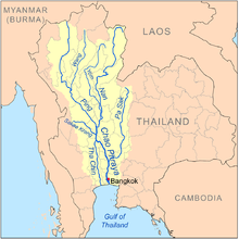
The Tha Chin river (Thai: แม่น้ำท่าจีน, RTGS: Maenam Tha Chin, pronounced [mɛ̂ːnáːm tʰâː tɕīːn]) is a distributary of the Chao Phraya river, Thailand. It splits near the province of Chai Nat and then flows west from the Chao Phraya through the central plains, until it empties into the Gulf of Thailand in Samut Sakhon Province.

Regional names
The Tha Chin river has many regional names. After it splits from Chao Phraya river at Chai Nat, it is called Makham Thao River; while passing Suphan Buri it is the Suphan River; while passing Nakhon Pathom it becomes the Nakhon Chai Si river. Only near its mouth at Samut Sakhon does it become the Tha Chin River, named after the former name of Samut Sakhon. The name Tha Chin is the convention used in most scientific documents.
Tributaries
Tributaries of the Tha Chin include Huai Krasiao, Huai Mae Thawip, Khlong Chorakhe Sam Phan, and Khlong Bang Len.
Tha Chin basin
The Tha Chin drains a total area of 13,681 square kilometers (5,282 sq mi).[1] The Tha Chin Basin is part of the Chao Phraya Watershed.
Past journey
In the past, there used to be passenger boats running back and forth on the Tha Chin River from Suphan Buri to Tha Tian Pier in Bangkok. From time to time, passengers will disembark at Wat Ngiu Rai Railway Station to travel by train to Bangkok. The passenger boat business is owned by the private company Suphan Steam Packet Company.
Later, when land transportation is more prosperous and convenient. Therefore, water transportation is sluggish. The passenger navigation business on the Tha Chin River therefore ceased in the early 1960's.[2]
Health of the river
The Thai Pollution Control Department (PCD) has reported that the water quality of rivers flowing into the upper Gulf of Thailand has seriously deteriorated in the past decade. The department found the Tha Chin estuary contains bacteria and nutrient pollution from phosphates, phosphorus, and nitrogen. Nutrient pollution causes algae to grow faster than ecosystems can handle, harming water quality, food resources for aquatic animals, and marine habitats. It also decreases the oxygen that fish need to survive. PCD rated water quality in the river in 2015 as "poor".[3]: 56 The PCD findings indicated large amounts of wastewater were discharged into the river from households, industry, and agriculture.[4]
References
- Basins of Thailand[permanent dead link]
- "ท่าจีน" [Tha Chin]. TPBS (in Thai). 2022-03-20. Retrieved 2022-03-22.
- Thailand State of Pollution Report 2015 (PDF). Bangkok: Pollution Control Department. ISBN 978-616-316-327-1. Retrieved 23 September 2016.
- Wangkiat, Paritta (25 September 2016). "Breach of trust". Bangkok Post. Retrieved 25 September 2016.
Authority control | |
|---|---|
| General |
|
| National libraries | |
На других языках
[de] Mae Nam Tha Chin
Der Mae Nam Tha Chin (Thai: .mw-parser-output .Thai{font-size:115%}แม่น้ำท่าจีน – gesprochen: [.mw-parser-output .IPA a{text-decoration:none}mɛ̂ː náːm tʰâː t͡ɕiːn], übersetzt etwa: „Fluss des chinesischen Hafens“), oder nur Tha Chin ist ein Fluss in Zentral-Thailand. Er wechselt in seinem Verlauf mehrmals den Namen:- [en] Tha Chin River
[es] Río Tha Chin
El río Tha Chin (en tailandés: ท่าจีน) es un río de Tailandia, el principal distributario del río Chao Phraya. Se divide cerca de la ciudad de Chainat y entonces fluye hacia el oeste desde el Chao Phraya a través de una llanura central, hasta que llega al golfo de Tailandia en la ciudad de Samut Sakhon.[it] Tha Chin
Il fiume Tha Chin è un effluente del Chao Phraya e scorre nella parte ovest della grande pianura alluvionale che forma la Thailandia Centrale. È lungo circa 325 km e sfocia con un estuario nella baia di Bangkok. Tha Chin (in lingua thai: ท่าจีน, letteralmente porto cinese) è l'antico nome di Samut Sakhon, la città dove il fiume sfocia in mare, così chiamata probabilmente per il grande numero di giunche cinesi che attraccavano nel suo porto.[2][ru] Тхачин
Тхачин (тайск. ท่าจีน) — река в Таиланде, крупнейший рукав реки Чаупхрая.Другой контент может иметь иную лицензию. Перед использованием материалов сайта WikiSort.org внимательно изучите правила лицензирования конкретных элементов наполнения сайта.
WikiSort.org - проект по пересортировке и дополнению контента Википедии