geo.wikisort.org - River
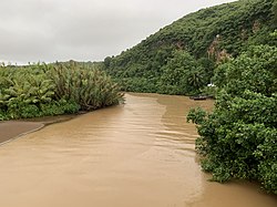
The Talofofo River[1] is one of the longest rivers on the Pacific Ocean island of Guam. Rising on the eastern slopes of Mount Lamlam in the island's south-west, it traverses the island in a north-eastward direction, flowing into the sea at Talofofo Bay.
| Talofofo River | |
|---|---|
 Talofofo River near the mouth | |
| Physical characteristics | |
| Mouth | |
• coordinates | 13.3372222°N 144.7597222°E |
Major features of the river's course include Fena Lake, Guam's largest lake, and the Talofofo Falls. The river has one major tributary, the Ligum River, which joins it close to its mouth.
References
Текст в блоке "Читать" взят с сайта "Википедия" и доступен по лицензии Creative Commons Attribution-ShareAlike; в отдельных случаях могут действовать дополнительные условия.
Другой контент может иметь иную лицензию. Перед использованием материалов сайта WikiSort.org внимательно изучите правила лицензирования конкретных элементов наполнения сайта.
Другой контент может иметь иную лицензию. Перед использованием материалов сайта WikiSort.org внимательно изучите правила лицензирования конкретных элементов наполнения сайта.
2019-2025
WikiSort.org - проект по пересортировке и дополнению контента Википедии
WikiSort.org - проект по пересортировке и дополнению контента Википедии
