geo.wikisort.org - River
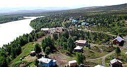
The Stony River (Deg Xinag: Gidighuyghatno' Giqedhatno; Dena'ina: K'qizaghetnu) is a 190-mile (310 km) tributary of the Kuskokwim River in the U.S. state of Alaska.[1] The river flows south from near Mount Mausolus in the Revelation Mountains of the Alaska Range through the northwestern corner of Lake Clark National Park and Preserve. From there, it flows generally westward to meet the larger river at the community of Stony River.[3]
| Stony River | |
|---|---|
 | |
 Location of the mouth of the Stony River in Alaska | |
| Native name |
|
| Location | |
| Country | United States |
| State | Alaska |
| Census Area | Bethel |
| Physical characteristics | |
| Source | Stony Glacier |
| • location | Revelation Mountains, Alaska Range |
| • coordinates | 61°36′18″N 153°45′40″W[1] |
| • elevation | 2,856 ft (871 m)[2] |
| Mouth | Kuskokwim River |
• location | 20 miles (32 km) northeast of Sleetmute |
• coordinates | 61°46′10″N 156°35′28″W[1] |
• elevation | 200 ft (61 m)[1] |
| Length | 190 mi (310 km)[1] |
Boating
The Stony River, navigable by kayak, canoe, and small to medium raft, is "suitable for moderately experienced boaters with good wilderness skills."[4] The river varies in difficulty from Class I (easy) to II (medium) on the International Scale of River Difficulty. Dangers include rocky rapids in the 19 miles (31 km) of stream passing through canyons, where standing waves may reach up to 8 feet (2.4 m) in high water.[4]
See also
- List of Alaska rivers
References
- "Stony River". Geographic Names Information System. United States Geological Survey. March 31, 1981. Retrieved November 16, 2013.
- Derived by entering source coordinates in Google Earth.
- Alaska Atlas & Gazetteer (7th ed.). Yarmouth, Maine: DeLorme. 2010. pp. 78–79, 131. ISBN 978-0-89933-289-5.
- Jettmar, Karen (2008) [1993]. The Alaska River Guide: Canoeing, Kayaking, and Rafting in the Last Frontier (3rd ed.). Birmingham, Alabama: Menasha Ridge Press. pp. 187–88. ISBN 978-0-89732-957-6.
На других языках
[de] Stony River (Kuskokwim River)
Der Stony River ist ein 306 km langer linker Nebenfluss des Kuskokwim River im südwestlichen Interior von Alaska.- [en] Stony River (Alaska)
Другой контент может иметь иную лицензию. Перед использованием материалов сайта WikiSort.org внимательно изучите правила лицензирования конкретных элементов наполнения сайта.
WikiSort.org - проект по пересортировке и дополнению контента Википедии