geo.wikisort.org - River
The Singapore River is a river that flows parallel to Alexandra Road and feeds into the Marina Reservoir in the southern part of Singapore. The immediate upper watershed of the Singapore River is known as the Singapore River Planning Area, although the western part of the watershed is classified under the River Valley planning area.
| Singapore River | |
|---|---|
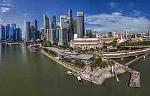
 Singapore River flowing through Singapore's central business district. | |
 Early 19th century map of the Singapore River basin. | |
| Native name | |
| Location | |
| Country | |
| Physical characteristics | |
| Source | |
| • location | Alexandra Canal |
| Mouth | |
• location | Marina Channel |
| Length | 3.2 km (2.0 mi) |
Singapore River | |
|---|---|
Planning Area | |
| Other transcription(s) | |
| • Chinese | 新加坡河 Xīnjiāpō hé (Pinyin) Sin-ka-pho hô (Hokkien POJ) |
| • Malay | Sungai Singapura (Rumi) سوڠاي سيڠاڤورا (Jawi) |
| • Tamil | சிங்கப்பூர் நதி Ciṅkappūr nati (Transliteration) |
 Location in Central Region | |
| Country | |
| Region | Central Region
|
| CDC |
|
| Town council |
|
| Constituency |
|
| DGP exhibited |
|
| PA incorporated |
|
| Government | |
| • Mayor | Central Singapore CDC
|
| • Members of Parliament | Tanjong Pagar GRC
Jalan Besar GRC
|
| Area | |
| • Total | 0.96 km2 (0.37 sq mi) |
| • Rank | 52nd |
| Population (2018) | |
| • Total | 3,070 |
| • Rank | 32nd |
| • Density | 3,200/km2 (8,300/sq mi) |
| • Rank | 31st |
| Postal district | 01, 03, 06, 09, 10 |
Singapore River planning area sits within the Central Area of the Central Region of Singapore, as defined by the Urban Redevelopment Authority. The planning area shares boundaries with the following – River Valley and Museum to the south, Tanglin and Bukit Merah to the west, Outram to the south and the Downtown Core to the east.
Since 2008, the Singapore River was turned into a fresh water river after the completion of the Marina Barrage at Marina South.
Geography
The Singapore River is approximately 3.2 kilometers long[2] from its source at Kim Seng Bridge to where it empties into Marina Bay; the river extends more than two kilometers beyond its original source at Kim Seng Bridge as Alexandra Canal, as far as the junction of Commonwealth Avenue.[citation needed]
History
This section needs expansion. You can help by adding to it. (September 2022) |
The mouth of the Singapore River was the old Port of Singapore, being naturally sheltered by the southern islands. Historically, the city of Singapore initially grew around the port so the river mouth became the centre of trade, commerce and finance.
Old maps of the river state that it actually originates from Bukit Larangan (currently Fort Canning Hill).
Heavy traffic

Starting in 1819, there was heavy traffic on the Singapore River due to rapid urbanization and expanding trade.[3] At the same time, it brought in water pollution caused by the disposal of garbage, sewage and other by-products of industries located along the river's banks. The sources of water pollution into the Singapore River and Kallang Basin included waste from pig and duck farms, unsewered premises, street hawkers and vegetable whole sellers. Riverine activities such as transport, boat building and repairs were also found along the Singapore River.
Some 750 lighters plied along the Singapore River and Kallang Basin in 1977. Waste, oil spills and wastewater from these boats and lighters added to the pollution of the rivers. In 1977, Prime Minister Lee Kuan Yew called for a clean up of Singapore's rivers, which included the Singapore River and the Kallang River. The clean up cost the government $300 million at the time and involved a relocation of about 4,000 squatters, along with hawkers and vegetable sellers, whose daily waste flowed into the river. Public housing was found for the squatters, while street hawkers were persuaded to move to established hawker centres. The government then completely dredged foul-smelling mud from the banks and the bottom of the river, clearing the debris and other rubbish.[4]
Singapore River today
Due to such cleaning efforts, the Singapore River has significantly changed from one that was heavily busy and polluted to one that is clean with marine animals. The re-emergence of monitor lizards and otters in the Singapore River has been attributed to the success of the river's cleanup.[5][6]
Whereas the original mouth of the Singapore River emptied into Singapore Straits and its southern islands before major land reclamation took place, the Singapore River now empties into Marina Bay – an area of water partially enclosed by the reclamation work.
The Port of Singapore is now located to the west of the island, using most of the south-west coast, and passenger ships to Singapore now typically berth at the Singapore Cruise Centre at Harbourfront. Thus the Singapore River's economic role has shifted away from one that of trade, towards more a role accommodated for tourism and aesthetics for the commercial zone which encloses it. Traversing across the river is available via water taxis.[7]
The river is now part of the Marina Reservoir after damming the Singapore River at its outlet to the sea to create a new reservoir of freshwater. The dam is known as the Marina Barrage.[8]
Sculptures
There are a number of sculptures along the Singapore River.[9] Many of these depict the life of people living and working along the river during the early days of Singapore.
Notable sculptures include:[10]
- First Generation, made by Chong Fah Cheong
- Fishing at Singapore River, made by Chern Lian Shan
- The River Merchants, made by Aw Tee Hong
- A Great Emporium, made by Malcolm Koh
- From Chettiars to Financiers, made by Chern Lian Shan
- Singapura Cats, made by various artists
Bridges and tunnels

Between 1819, when the first wooden jetty and the first bridge were built over the Singapore River in Singapore, and in 2015, 14 bridges were built across the river (or 17, although Marina Reservoir, where the estuary is now located, is considered a Singapore River). Until 1819, the river could only be crossed by boats and ferries. Some of the bridges were demolished and rebuilt or their purpose was changed (traffic bridge in pedestrian bridge and the like).
Former records from Singapore show a simple wooden bridge over the river from 1819, which had no name, and is considered the first bridge in the city. In 1822, the bridge was replaced by a wooden bridge, the Presentment Bridge, from which later (1862 and 1927) today's Elgin Bridge emerged. In the years that followed, other bridges such as Coleman Bridge (1840), Kim Seng Bridge (1862), Cavenagh Bridge (1869) or Read Bridge (1889) were added. The most recent bridges are the Helix Bridge (2010), Bayfront Bridge (2010) and the Jubilee Bridge (2015).

- Elgin Bridge (1819/1922)
- Coleman Bridge (1840/1985)
- Kim Seng Bridge (1862)
- Cavenagh Bridge (1870)
- Ord Bridge (1886)
- Read Bridge (1889)
- Pulau Saigon Bridge (1890)
- Anderson Bridge (1910)
- Clemenceau Bridge (1940)
- East West MRT line and North South MRT line between City Hall and Raffles Place (1987/1989)
Aerial Panorama of Merlion Park. The Singapore River ends its journey here - Esplanade Bridge (1997)
- Jiak Kim Bridge (1999)
- Robertson Bridge (1998)
- Benjamin Sheares Bridge (1981)
- Alkaff Bridge (1999)
- North East MRT line between Clarke Quay and Dhoby Ghaut (2003)
- Helix Bridge (2010)
- Bayfront Bridge (2010)
- Downtown MRT line and Circle MRT line between Promenade and Bayfront (2012)
- Jubilee Bridge (2015)
- Downtown MRT line between Fort Canning and Chinatown (2017)

Gallery

 Bird Sculpture by Fernando Botero
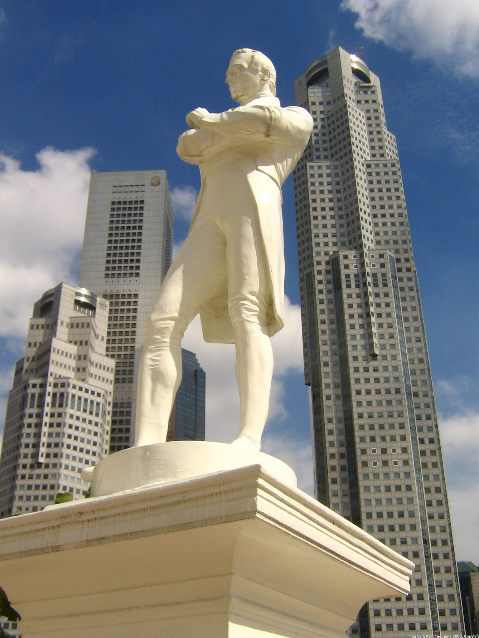
 Statue of Stamford Raffles
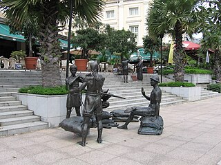 A Great Emporium by Malcolm Koh
 The First Generation by Chong Fah Cheong
 The Dalhousie Obelisk
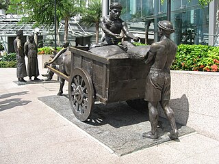 The River Merchants by Aw Tee Hong


References
| Library resources about Singapore River |
- "Singapore Infopedia – Development guide plan". National Library Board.
- Leary, Michael E.; McCarthy, John (2013-10-30). The Routledge Companion to Urban Regeneration. Routledge. p. 132. ISBN 9781136266546.
- "Singapore River". Heritage Trails. Archived from the original on 2009-08-22. Retrieved 2010-04-01.
- migration (2014-07-04). "5 interesting facts about the Singapore River clean-up". Retrieved 2016-07-09.
- "Cheeky otters are thriving in Singapore—and adapting quickly to big city life". National Geographic. March 10, 2020.
- Ng, Cherlynn (18 March 2022). "TGIF: Monitor lizards have family feast along Kallang River". Stomp. Retrieved 11 June 2022.
- "Singapore River". www.ura.gov.sg. Retrieved 11 June 2022.
- "PUB annual report: Birth of the barrage". PUB. 2008. Archived from the original on 7 April 2015. Retrieved 29 September 2016.
- "Sir Stamford Raffles statue and other sculptures along Singapore River to be cleaned next week". The Straits Times. Singapore. 3 February 2015. Retrieved 2015-11-23.
- Ang, Benson (18 September 2016). "Sculptures by the Singapore River get a spruce up". The Straits Times. Retrieved 19 September 2016.
External links
 Media related to Singapore River at Wikimedia Commons
 Singapore River travel guide from Wikivoyage
Authority control | |
|---|---|
| General |
|
| National libraries | |
На других языках
[de] Singapore River
Der Singapore River (malai. Sungai Singapura, chinesisch .mw-parser-output .Hani{font-size:110%}新加坡河, Pinyin Xīnjiāpō Hé) ist ein kleiner Fluss, der sich seinen Weg durch das Stadtgebiet von Singapur bahnt und der für die Stadt eine große historische Bedeutung besitzt. Der Singapore River beginnt in der Central Area im südlichen Teil der Stadt Singapur und strömt schließlich in die Marina Bay, die den Zugang zum Pazifischen Ozean bildet. Das obere Einzugsgebiet des Flusswassers ist als die Singapore River Planning Area bekannt, der nördlichste Teil der Wasserscheide ist das River Valley. Nahezu alle Ufergebiete des Flusses gehören den zentralen Handelsdistrikten der Stadt an. Er ist einer von insgesamt 90 Fließgewässern, die in Singapur und den zum Stadtstaat gehörenden Inseln existieren.- [en] Singapore River
[it] Singapore (fiume)
Il fiume Singapore è il più lungo fiume dello Stato omonimo.[ru] Сингапур (река)
Сингапур (малайск. Sungei Singapura, кит. 新加坡河) — река на острове Сингапур. Протекает по Центральному региону Сингапура и впадает в Сингапурский пролив.Другой контент может иметь иную лицензию. Перед использованием материалов сайта WikiSort.org внимательно изучите правила лицензирования конкретных элементов наполнения сайта.
WikiSort.org - проект по пересортировке и дополнению контента Википедии