geo.wikisort.org - River
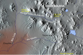
The Silala or Siloli[1] is an aquifer and river arising from springs in Bolivia, and flowing into Chile.
| Silala | |
|---|---|
 Loa and its tributaries San Pedro, Silala and Salado Rivers | |
| Location | |
| Countries |
|
| Department (BO) | Potosí |
| Region (CL) | Antofagasta |
| Physical characteristics | |
| Source | |
| • elevation | c. 4400 m asl[1] |
| Mouth | |
• location | Inacaliri River[1] |
| Length | 8.5 km[1] |
| Discharge | |
| • location | Bolivia–Chile border |
| • average | 160 L/s[1] |
The division of the flow from this water body has been a matter of controversy between the two nations, Chile claiming that the present route makes it an international river, while Bolivia denies there is a river and asserts that the Silala ‘springs’ would not flow to Chile if not for the construction of canals over a hundred years ago.[2][3][4][5]
See also
- Dispute over the Status and Use of the Waters of the Silala
References
- Notes
- Application, June 6, 2016
- tierraamerica.net Archived 2011-07-27 at the Wayback Machine
- Newton, Joshua, "The Disputed Silala River: A Catalyst for Cooperation? " (2007). Water Resources Research Center Conferences. Paper 28. link Accessed 8 April 2011
- Gabriel Eckstein and Brendan M. Mulligan Water Resources Development, Vol. 27, No. 3, pp. 595-606, September 2011. Posted on SSRN September 1, 2011 link Accessed 8 April 2011
- Gabriel Eckstein. The Silala Basin: One of the Most Hydropolitically Vulnerable Basins in the World. International Water Law Project Blog link Accessed 8 April 2011
- Sources
- EVALUACION DE LOS RECURSOS HIDRICOS SUPERFICIALES EN LA CUENCA DEL RIO BIO BIO[permanent dead link] (PDF)
Hydrography of Antofagasta Region | ||
|---|---|---|
| Rivers | ||
| Lakes | ||
| Salt pans |
| |
| Authority control: National libraries |
|---|
This Antofagasta Region location article is a stub. You can help Wikipedia by expanding it. |
На других языках
[de] Silala
Die Silala-Quelle ist ein System von mehreren hundert Quellen am Westrand der Siloli-Wüste in Bolivien und gehört zum Einzugsbereich des chilenischen Flusses Río Loa.- [en] Silala River
[es] Silala
El Silala, también llamado Siloli o río Silala, es un sistema hídrico ubicado en la zona del altiplano andino, entre Bolivia y Chile.[1] Su origen se ubica en el departamento boliviano de Potosí y, desde allí, el curso de agua recorre 56 kilómetros, cruzando la frontera internacional entre ambos países, hasta desembocar en los ríos San Pedro de Inacaliri y posteriormente al Loa, en la región chilena de Antofagasta.Текст в блоке "Читать" взят с сайта "Википедия" и доступен по лицензии Creative Commons Attribution-ShareAlike; в отдельных случаях могут действовать дополнительные условия.
Другой контент может иметь иную лицензию. Перед использованием материалов сайта WikiSort.org внимательно изучите правила лицензирования конкретных элементов наполнения сайта.
Другой контент может иметь иную лицензию. Перед использованием материалов сайта WikiSort.org внимательно изучите правила лицензирования конкретных элементов наполнения сайта.
2019-2026
WikiSort.org - проект по пересортировке и дополнению контента Википедии
WikiSort.org - проект по пересортировке и дополнению контента Википедии