geo.wikisort.org - River
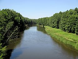
The Shchara (Belarusian: Шчара, Ščara, pronounced [ˈʂtʂara]; Russian: Щара) is a river in Belarus, and is the left tributary of the Neman. It is 300 km (190 mi) in length, its catchment area being 6,730 km2 (2,600 sq mi). The Shchara is the 5th longest river in Belarus.[1]
| Shchara | |
|---|---|
 | |
| Location | |
| Country | Belarus |
| Physical characteristics | |
| Source | |
| • location | Grodno Region |
| Mouth | Neman |
• coordinates | 53.4402°N 24.7388°E |
| Length | 300 km (190 mi)[1] |
| Basin size | 6,730 km2 (2,600 sq mi)[1] |
| Discharge | |
| • average | 31 m3/s (1,100 cu ft/s) |
| Basin features | |
| Progression | Neman→ Baltic Sea |
It flows through Slonim.
Main tributaries
Right: Lipnyanka, Myshanka, Lakhazva, Isa, Padyavarka.
Left: Vedma, Grivda, Lukonitsa, Sipa.
References
- "Main characteristics of the largest rivers of Belarus". Land of Ancestors. Data of the Ministry of Natural Resources and Environmental Protection of the Republic of Belarus. 2011. Retrieved 27 September 2013.
На других языках
[de] Schtschara
Die Schtschara (belarussisch Шчара; russisch Щара) ist ein 325 km langer Nebenfluss der Memel in den Woblaszen Brest und Hrodna in Belarus.- [en] Shchara
[it] Ščara
La Ščara (pronuncia [ˈʂtʂara], in bielorusso: Шчара?, in russo: Щара?, spesso indicato con la traslitterazione anglosassone Shchara) è un fiume della Bielorussia, affluente di sinistra del Nemunas[1].[ru] Щара
Ща́ра (белор. Шчара) — река в Брестской и Гродненской областях Белоруссии, левый приток Немана. Длина — 300 км, площадь бассейна — 6730[1] км². Средний расход воды — 31 м³/сек.Текст в блоке "Читать" взят с сайта "Википедия" и доступен по лицензии Creative Commons Attribution-ShareAlike; в отдельных случаях могут действовать дополнительные условия.
Другой контент может иметь иную лицензию. Перед использованием материалов сайта WikiSort.org внимательно изучите правила лицензирования конкретных элементов наполнения сайта.
Другой контент может иметь иную лицензию. Перед использованием материалов сайта WikiSort.org внимательно изучите правила лицензирования конкретных элементов наполнения сайта.
2019-2025
WikiSort.org - проект по пересортировке и дополнению контента Википедии
WikiSort.org - проект по пересортировке и дополнению контента Википедии
