geo.wikisort.org - River
The Río Grande de Santiago, or Santiago River,[3] is a river in western Mexico. It flows westwards from Lake Chapala via Ocotlán through the states of Jalisco and Nayarit to empty into the Pacific Ocean. It one of the longest rivers in Mexico, measuring up 433 km (269 mi) long.
This article may be expanded with text translated from the corresponding article in Spanish. (July 2012) Click [show] for important translation instructions.
|
| Río Grande de Santiago | |
|---|---|
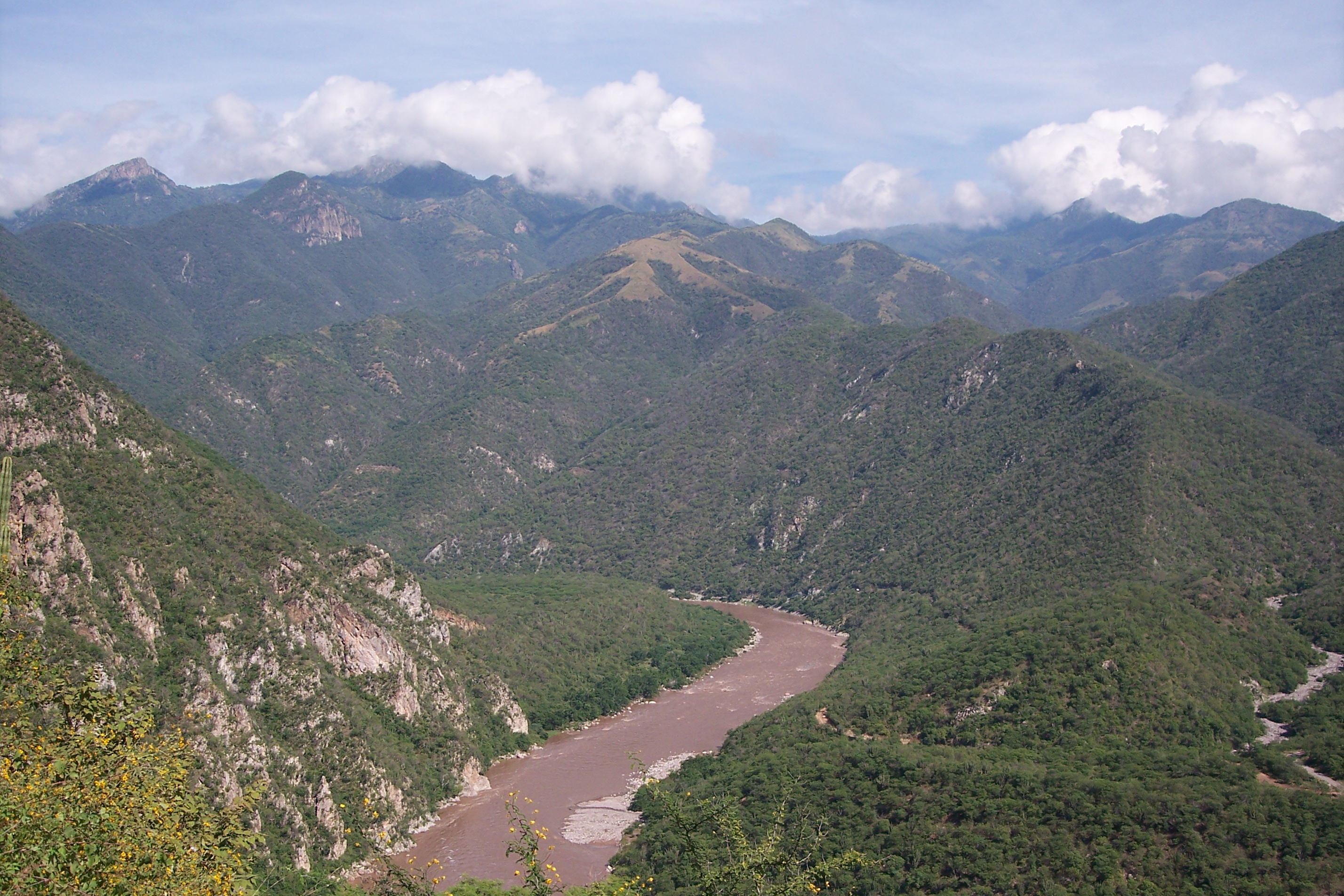 Río Grande de Santiago at the Nayarit–Jalisco border | |
 Major rivers of Mexico, with the Rio Grande de Santiago (labelled Rio Santiago) in west–center | |
 Location of mouth | |
| Location | |
| Country | Mexico |
| Physical characteristics | |
| Source | |
| • location | Lake Chapala via Ocotlán |
| Mouth | |
• location | Pacific Ocean at San Blas / Santiago Ixcuintla, Nayarit |
• coordinates | 21°37′41″N 105°26′52″W |
| Length | 433 km (269 mi) |
| Basin size | 136,628 square kilometres (52,752 sq mi)[1] |
| Discharge | |
| • average | Average: 320 cubic metres per second (11,000 cu ft/s) Maximum: 2,113 cubic metres per second (74,600 cu ft/s) Minimum: 29.5 cubic metres per second (1,040 cu ft/s) [2] |
| Basin features | |
| Tributaries | |
| • left | Mololoa River |
| • right | Río Verde, Juchipila River, Bolaños River, Huaynamota River |
Geography
The river begins at Lake Chapala via Ocotlán and continues roughly north-west through the Sierra Madre Occidental, receiving the Verde, Juchipila, Bolaños, Huaynamota, Mololoa, and other tributaries.
The Río Grande de Santiago descends over 1700 meters between Lake Chapala and the sea. Downstream from Lake Chapala the river and its major tributaries have carved deep narrow canyons, or barrancas, which can be 600 meters lower than the surrounding plateau. The lower elevation and year-round moisture in the canyon bottoms sustain forests, which include many coastal tropical species not found on the plateaus.[4] The Barranca de Oblatos or Barranca de Huentitán is a protected area popular with residents of the city of Guadalajara, which lies on the plateau immediately south of the barranca.
At La Yesca, the La Yesca Dam was completed in 2012 and the El Cajón Dam was completed downstream in 2007. Below El Cajón, the Aguamilpa Dam was completed in 1993, creating a reservoir covering a large part of the territory of the municipality of El Nayar in Nayarit.
From Aguamilpa, the river descends to the coastal lowlands, passing by Santiago Ixcuintla and empties into the Pacific Ocean, 16 km (10 mi) northwest of San Blas, in Nayarit.
The Santiago River alone is reported to be 269 miles long. It is viewed by some sources as a continuation of the Lerma River, which flows into Lake Chapala and at 466 miles long is one of Mexico's longest rivers. Together the Lerma–Santiago river system is a little over 600 miles long.[5]
Fauna
The remote chub (Algansea avia), mountain chub (Algansea monticola), and Chapala catfish (Ictalurus ochoterenai) are endemic to the Río Grande de Santiago and its tributaries.[6]
Pollution
Mexico possesses a small percentage (0.1%) of the world's freshwater reserve. According to an article named Water use (and abuse) and its effects on the crater-lakes of Valle de Santiago, Mexico “most Mexican lakes are in an advanced state of desiccation or senescence, with volumes and surface area greatly reduced because of human activities”.[7] Some examples of these damaging activities are wood cutting, inflow diversion for agriculture, groundwater over extraction, pollution and eutrophication.
Less than fifty years ago the river was a place to fish, bathe, and swim.[citation needed] It is now a river full of pollutants. The Instituto Mexicano de Tecnología del Agua (IMTA) found over a thousand different chemicals in the main channel and its tributaries. These substances included semi-volatile and volatile organic compounds, such as phthalates (hormonal disruptors), phenols (compounds that affect neuronal development), toluene (a neurotoxin), and carcinogenic flame retardants.[8] This river is one of the most polluted in Mexico.[9]
In February 2008 an eight-year-old boy, Miguel Angel Lopez Rocha, died after he fell into the river.[10] Rocha fell near the El Salto Falls. He died nineteen days later. His autopsy indicated heavy metal poison was the reason for his death. This brought attention to the severe contamination of the river. After this unfortunate incident the local community organized a group called "Un Salto de Vida" ("A Leap for Life"), which sponsored the second National Assembly on Environmental Impacts held in El Salto in May 2009.[11][12]
See also
References
- "Rio Grande de Santiago Watershed". Watersheds of the World: North and Central America. World Resources Institute – EarthTrends. 2006. Archived from the original on 2011-06-11. Retrieved 2010-05-30.
- "Santiago Discharge near El Capomal". River Discharge Database. Center for Sustainability and the Global Environment. 1965–1981. Archived from the original on 2010-06-14. Retrieved 2010-05-30.
- Río Grande de Santiago (Approved - N at GEOnet Names Server, United States National Geospatial-Intelligence Agency
- Selander, Robert K., and Donald R. Giller. "The Avifauna of the Barranca De Oblatos, Jalisco, Mexico." The Condor, vol. 61, no. 3, 1959, pp. 210–222. JSTOR, www.jstor.org/stable/1365537. Accessed 11 Sept. 2021.
- González, Paulina Martinez; Hernández, Eduardo (2009). "Impactos de la contaminación del Río Santiago en el bienestar de los habitantes de El Salto, Jalisco / Impacts from Contamination of the Santiago River on the Well-being of the Inhabitants of El Salto, Jalisco" (PDF). Espacio Abierto Cuaderno Venezolano de Sociología. 18 (4): 708–729, page 711.
- Contreras Balderas, Salvador and Jennifer Hales. "Rio Santiago". Freshwater Ecoregions of the World. Accessed 7 September 2021.
- Alcocer, Javier; Escobar, Elva; Lugo, Alfonso. "Water use (and abuse) and its effects on the crater-lakes of Valle de Santiago, Mexico". ResearchGate.net. Retrieved 4 November 2018.
- Enciso L., Angelica (25 March 2013). "Muerte lenta del río Santiago por contaminación". La Jornada. Mexico City. Archived from the original on 12 August 2018. Citing the report "Actualización del estudio de calidad del agua del río Santiago"
- "To Kill A River, How Mexico's Santiago Was Polluted Beyond Repair". worldcrunch.com. 22 October 2017. Retrieved 8 February 2021.
- González & Hernández 2009, p. 713
- Alcocer, Javier, Elva Escobar, and Alfonso Lugo. "Water Use (And Abuse) and Its Effects on the Crater‐lakes of Valle De Santiago, Mexico." Lakes & Reservoirs: Research & Management, 5.3 (2000): 145–149.
- Gómez-Balandra, María Antonieta, Edmundo Díaz-Pardo, and Altagracia Gutiérrez-Hernández. "Composición De La Comunidad íctica De La Cuenca Del Río Santiago, México, Durante Su Desarrollo Hidráulico Fish Community Composition of the Santiago River Basin, Mexico, During Its Hydraulic Development." Hidrobiológica, 22.1 (2012): 62–68.
External links
На других языках
- [en] Río Grande de Santiago
[es] Río Grande de Santiago
El río Grande de Santiago (también, Santiago Totolotlán o simplemente Santiago), es un río que está localizado en el Occidente de México. Nace en Ocotlán, en la ribera oriental del lago de Chapala, a una altitud de 1524 msnm, y discurre por los estados de Jalisco y Nayarit, delimitando su frontera a lo largo de unos 30km. Su caudal fluye a un costado de la zona metropolitana de Guadalajara y desemboca en el océano Pacífico (cerca de San Blas, Nayarit). Su trayecto es de 562 km y drena una cuenca de 76 400 km².[1] En él se encuentran las presas: El Cajón (2007), Aguamilpa (1994) y Santa Rosa (1964), la presa reguladora San Rafael, la presa derivadora El Gileño y La Yesca.[ru] Рио-Гранде-де-Сантьяго
Рио-Гранде-де-Сантьяго (исп. Río Grande de Santiago) — река в центральной Мексике, в штатах Халиско и Наярит. Длина составляет 443 км[1], площадь бассейна — 125 тысяч км²[2]. Средний расход воды — 380 м³/с[2].Другой контент может иметь иную лицензию. Перед использованием материалов сайта WikiSort.org внимательно изучите правила лицензирования конкретных элементов наполнения сайта.
WikiSort.org - проект по пересортировке и дополнению контента Википедии