geo.wikisort.org - River
The Roya (French, [ʁwaja]), Roia (Italian), or Ròia (Brigasc, Occitan) is a river of France and Italy, discharging into the Ligurian Sea. It is 59 km (37 mi) long, of which 40.1 km (24.9 mi) in France.[1] Its drainage basin is about 660 km2 (250 sq mi), of which 601 km2 (232 sq mi) in France.[2]

| Roya Roia, Roja | |
|---|---|
 The river at Ventimiglia | |
 | |
| Location | |
| Countries | France and Italy |
| Physical characteristics | |
| Source | |
| • location | Colle di Tenda near Tende, France. |
| • elevation | 1,908 m (6,260 ft) |
| Mouth | |
• location | Ligurian Sea at Ventimiglia, Italy |
• coordinates | 43°47′17″N 7°36′22″E |
• elevation | 0 m (0 ft) |
| Length | 59 km (37 mi) |
| Basin size | 660 km2 (250 sq mi) |
| Discharge | |
| • average | 15 m3/s (530 cu ft/s) |
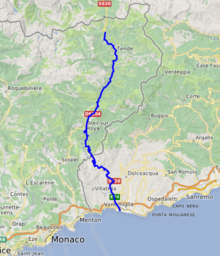
River course
The river rises in French territory near the Col de Tende and flows through the Mercantour National Park The river passes through the communes of Tende, Saorge, Breil-sur-Roya, La Brigue, before entering Italy in the commune of Olivetta San Michele. The remainder of its course remains within the province of Imperia and, after crossing Airole the river enters the sea at Ventimiglia.[3]
Its main tributaries are the Lévensa, the Bévéra, the Bendola, the Réfréi and the Maglia.
References
- Sandre. "Fiche cours d'eau - La Roya (Y66-0400)".
- Bassin versant : Roya (La), Observatoire Régional Eau et Milieux Aquatiques en PACA
- The Times (1985), Atlas of the World: Comprehensive Edition, Times Books, Plate 78 (C7).
Authority control | |
|---|---|
| General |
|
| National libraries | |
| Other |
|
This Alpes-Maritimes geographical article is a stub. You can help Wikipedia by expanding it. |
This Provence-Alpes-Côte d'Azur geography article is a stub. You can help Wikipedia by expanding it. |
This Liguria location article is a stub. You can help Wikipedia by expanding it. |
На других языках
[de] Roya
Die Roya (italienisch: Roia) ist ein Fluss im Grenzgebiet zwischen Frankreich und Italien. Sie entspringt in den französischen Seealpen, östlich des Col de Tende (italienisch: Colle di Tenda), im Gemeindegebiet von Tende und entwässert generell in südlicher Richtung. Der obere Flusslauf liegt im französischen Nationalpark Mercantour. Das Gewässer weist ein erhebliches Gefälle auf und wird daher vor allem im Oberlauf von Wasserkraftwerken genutzt. Der Mittellauf bei Breil-sur-Roya weist dagegen eine gleichmäßige Wasserführung auf und kann daher für Kajak und Rafting genutzt werden. Das Gebirgstal der Roya verengt sich sehr häufig zu engen Schluchten, wird aber dennoch auf seiner gesamten Länge von der Tendabahn, einer der außergewöhnlichsten alpenquerenden Eisenbahnlinien, durchzogen. Die Roya erreicht bei Fanghetto italienisches Staatsgebiet und mündet nach insgesamt rund 59[3] Kilometern bei Ventimiglia in das Mittelmeer. Auf seinem Weg durchquert der Fluss das französische Département Alpes-Maritimes und die italienische Provinz Imperia.- [en] Roya (river)
[es] Río Roya
El río Roya (en italiano, Roia, en occitano, Ròia) es un corto río costero de la vertiente mediterránea que discurre por Francia e Italia.[it] Roia
Il Roia (anche Roja; in francese Roya, in roiasco/brigasco/ventimigliese Röia/Ròia) è un fiume italo-francese lungo 59 km[1] che scorre nel suo tratto finale in Liguria.[ru] Руайа (река)
Руайа (фр. Roya, окс. Ròia, итал. Roia) — река во Франции и Италии, впадает в Лигурийское море в городе Вентимилья. Протекает по территории французского департамента Приморские Альпы и итальянской провинции Империя. Длина реки — 60 км, площадь бассейна — 660 км², средний расход в устье — 15 м³/с. Крупнейший приток — Бевера (правый).Другой контент может иметь иную лицензию. Перед использованием материалов сайта WikiSort.org внимательно изучите правила лицензирования конкретных элементов наполнения сайта.
WikiSort.org - проект по пересортировке и дополнению контента Википедии