geo.wikisort.org - River
The Roosevelt River (Rio Roosevelt, sometimes Rio Teodoro) is a Brazilian river, a tributary of the Aripuanã River about 760 km (470 mi) in length.
| Roosevelt River | |
|---|---|
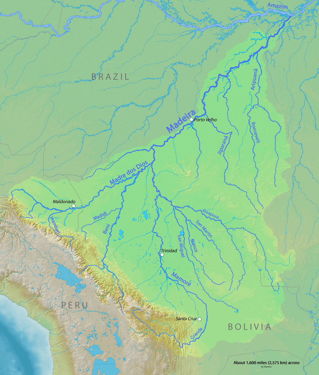 Madeira Basin with Roosevelt River center-right | |
| Location | |
| Country | Brazil |
| State | Rondônia |
| Physical characteristics | |
| Mouth | Aripuanã River |
• coordinates | 7°34′31″S 60°40′33″W |
| Length | 760 km (470 mi)[1] |
| Basin size | 59,649 km2 (23,031 sq mi)[2] |
| Discharge | |
| • location | mouth |
| • average | 1,487 m3/s (52,500 cu ft/s)[3] |
Course
The Roosevelt River begins in the state of Rondônia and flows north through tropical rainforest. It is fed by the Capitão Cardoso River, which meets it at the state boundary. In Mato Grosso the river forms the western boundary of the 164,224 hectares (405,810 acres) Guariba-Roosevelt Extractive Reserve, a sustainable use unit created in 1996.[4] After entering Amazonas the river forms the border between the 83,381 hectares (206,040 acres) Manicoré State Forest, a sustainable use conservation unit created in 2005 and the 72,296 hectares (178,650 acres) Guariba State Park, also created in 2005.[5] The river then runs through the Campos Amazônicos National Park, a 961,318 hectares (2,375,470 acres) protected area created in 2006 that holds an unusual enclave of cerrado vegetation in the Amazon rainforest.[6] It continues north until it joins the Aripuanã River. The Aripuanã then flows into the Madeira River, thence into the Amazon.
History and exploration
Formerly called Rio da Dúvida (“River of Doubt”), the river is named after Theodore Roosevelt, who traveled into the central region of Brazil during the Roosevelt–Rondon Scientific Expedition of 1913–14. The expedition, led by Roosevelt and Cândido Rondon, Brazil's most famous explorer and the river's discoverer, sought to determine where and by which course the river flowed into the Amazon.[7]
Roosevelt and his son Kermit undertook the adventure after the former U.S. president's failed attempt to regain the office as the "Bull Moose" candidate in 1912. The Roosevelt-Rondon expedition was the first non Amazonian-native party to travel and record what Rondon had named the "Rio da Dúvida", then one of the most unexplored and intimidating tributaries of the Amazon. Sections of the river have impassable rapids and waterfalls, which hindered the expedition.
Roosevelt later wrote Through the Brazilian Wilderness recounting the adventure. After Roosevelt returned doubts were raised on his account of the expedition. Roosevelt promptly rebutted them in a public forum in Washington, D.C., sponsored by the National Geographic Society. In 1927 British explorer George Miller Dyott led a second trip down the river, independently confirming Roosevelt's discoveries.[8]
In 1992 a third (modern) expedition was organized, funded, and led by Charles Haskell and Elizabeth McKnight of New Century Conservation Trust, a non-profit environmental education organization in Maine, and sponsored in part by the Theodore Roosevelt Association, the American Museum of Natural History, and the National Wildlife Federation.[9][10][11] This expedition consisted of a total of twenty persons including professional river guides Joe Willie Jones, Kelley Kalafatich, Jim Slade, and Mike Boyle, photographers Carr Clifton and Mark Greenberg, cinematographer Joe Kaminsky, Haskell's son Charles 'Chip' Haskell Jr. who served as the expedition's communications expert, Brazilian scientists Geraldo Mendes dos Santos and João Ferraz (ichthyologist and pharmacologist), and chiefs Oita Mina and Tatataré of the Cinta Larga tribe whose land borders much of the river. The expedition took 33 days to complete the nearly 1000-mile journey. While the Roosevelt-Rondon Expedition had to portage almost all of the many rapids on the river with their heavy dugout canoes, the Haskel-McKnight Expedition was able to safely navigate all of the rapids except for one which was portaged. Haskell reported that his expedition "found spots chronicled by the original team, saw plants and insects they described, and went down the rapids that crushed the dugout canoes of 1914". The expedition members were awarded the Theodore Roosevelt Association's Distinguished Service Medal for their achievement.[12] A documentary of the expedition was subsequently produced and aired on PBS called the "New Explorers: The River of Doubt" narrated by Bill Kurtis and Wilford Brimley.[13] Since this time, the expedition has inspired others to undergo its challenges such as Materials Scientist Professor Marc A. Meyers, Col Huram Reis, Col Ivan Angonese, and Jeffery Lehmann.[14]
Inhabitants
The upper reaches of the Roosevelt River are inhabited by the Cinta Larga people, who were first contacted in the 1960s. The Roosevelt Indigenous Reserve (reserva Roosevelt) was created in 1973 and is managed by FUNAI, occupies 2.7 million hectares (6.7×10⁶ acres), and has a population of 1,200.
References
- Ziesler & Ardizzone 1979.
- (PDF) http://meioambiente.am.gov.br/wp-content/uploads/2016/04/Produto-II-Diagn%25C3%25B3stico-Progn%25C3%25B3stico-e-Cen%25C3%25A1rios-volume-II.pdf.
{{cite web}}: Missing or empty|title=(help) - (PDF) http://meioambiente.am.gov.br/wp-content/uploads/2016/04/Produto-II-Diagn%25C3%25B3stico-Progn%25C3%25B3stico-e-Cen%25C3%25A1rios-volume-II.pdf.
{{cite web}}: Missing or empty|title=(help) - RESEX Guariba-Roosevelt – ISA.
- FES de Manicoré – ISA, Informações gerais (mapa).
- Parna Campos Amazônicos Mapa Interativo – Chico Mendes.
- Süssekind, Felipe (16 October 2018). O rastro da onça: relações entre humanos e animais no Pantanal (in Portuguese). ISBN 9788542107265.
- "River of Doubt", Time Magazine, June 6, 1927.
- James Brooke 1992.
- Warren E. Leary 1992.
- Elizabeth Haskell 2017
- "Distinguished Service Medal"
- "The New Explorers: River of Doubt"
- "UCSD Explorer Struggling in Amazon"
Sources
- FES de Manicoré (in Portuguese), ISA: Instituto Socioambiental, retrieved 2016-07-12
- James Brooke (February 25, 1992), "In T. R.'s Footsteps, Scientists Embark on Amazonian Expedition", New York Times, retrieved 2016-07-12
- Millard, Candice (2005), The River of Doubt: Theodore Roosevelt's Darkest Journey, New York: Doubleday, ISBN 0-385-50796-8
- Morris, Edmund (2010). Colonel Roosevelt. New York: Random House. ISBN 978-0-375-50487-7.
- Parna Campos Amazônicos Mapa Interativo (in Portuguese), Chico Mendes Institute for Biodiversity Conservation, retrieved 2016-06-03
- RESEX Guariba-Roosevelt (in Portuguese), ISA: Instituto Socioambiental, retrieved 2016-06-07
- Roosevelt, Theodore (1914). Through the Brazilian Wilderness. New York: C. Scribner's Sons. OCLC 485541.
- Warren E. Leary (April 10, 1992), "Explorers of Amazon Branch Retrace Roosevelt Expedition", New York Times, retrieved 2016-07-12
- Ziesler, R.; Ardizzone, G.D. (1979), "Amazon River System", The Inland waters of Latin America, Food and Agriculture Organization of the United Nations, ISBN 92-5-000780-9, archived from the original on 21 October 2013
External links
| Presidency |
|   |
|---|---|---|
| Other events |
| |
| Life and homes |
| |
| Writings and speeches |
| |
| Elections |
| |
| Legacy |
| |
| Popular culture |
| |
| Related |
| |
| Family |
| |
| ||
Authority control | |
|---|---|
| General |
|
| National libraries | |
На других языках
[de] Rio Roosevelt
Der Rio Roosevelt ist ein linker Nebenfluss des Rio Aripuanã im brasilianischen Amazonasgebiet. Er ist circa 750 km lang.- [en] Roosevelt River
[es] Río Roosevelt
El río Roosevelt (a veces, río Teodoro) es un largo río amazónico brasileño, un afluente del río Aripuanã, a su vez afluente del curso bajo del río Madeira, que discurre por los estados de Rondônia, Mato Grosso y Amazonas. Tiene una longitud total de 870 km.[1] El río lleva el nombre de Theodore Roosevelt, que viajó por la región en 1913.[ru] Рузвельт (река)
Ру́звельт (порт. Roosevelt) — река в Бразилии. Длина реки составляет около 760 км[1]. Исток реки находится в штате Рондония. Имеется ряд крупных притоков. Впадает слева в реку Арипуанан (порт. Aripuana), приток Мадейры[1][2][3]. На реке имеются пороги и водопады.Другой контент может иметь иную лицензию. Перед использованием материалов сайта WikiSort.org внимательно изучите правила лицензирования конкретных элементов наполнения сайта.
WikiSort.org - проект по пересортировке и дополнению контента Википедии