geo.wikisort.org - River
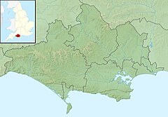
The River Wey is a chalk stream flowing through Dorset in south west England.
| River Wey | |
|---|---|
 The Wey at Upwey | |
| Location | |
| Country | England |
| County | Dorset |
| Physical characteristics | |
| Source | |
| • location | Upwey |
| • coordinates | 50.6667°N 2.4833°W |
| Mouth | |
• location | Weymouth Harbour |
• coordinates | 50.6118°N 2.4576°W |
Course
The river is about 12 kilometres (7.5 mi) long. It rises in Upwey,[1] where the spring forms Upwey Wishing Well, at the foot of the South Dorset Downs, a ridge of chalk hills that separate Weymouth from Dorchester. Most of the course is in the built-up area of Weymouth, running through the former villages (now suburbs) of Upwey, Broadwey, Nottington, and Radipole, through Radipole Lake and into Weymouth Harbour. From source to mouth it falls around 60 metres (200 ft).[2]
History
The river has been important since Roman times, when Radipole Lake was used as a reservoir.[2] The town of Weymouth was established by two harbour villages (Weymouth itself and Melcombe Regis) either side of the mouth.[3] The river was important for milling during the 18th and 19th century, when there were five water mills based along it. All five of the millers needed to carefully co-ordinate their activities to ensure a reliable flow of water.[2]
The source is an important water supply. There is a large pumping station at Friar Waddon, drawing from the source of the Wey, which is the main water supply for the Isle of Portland. Wessex Water is licensed to pump 14 megalitres of water a day.[2]
Environment
The river is important for wildlife; Radipole Lake is a national nature reserve run by the Royal Society for the Protection of Birds. It has been a Site of Special Scientific Interest since 1979. The spring water of the Wey is used by the Upwey fish farm. The farm also grows watercress, which can normally only be done in good quality water. All water in the farm must be recycled back to the river.[2]
See also
References
- "Wey". Catchment Data Explorer. Environment Agency. 31 March 2016. Retrieved 24 August 2016.
- "River Way". Royal Geographical Society. Retrieved 24 August 2016.
- Dorset (Slow Travel). Bradt Travel Guides. 2015. p. 189. ISBN 978-1-841-62867-7.
External links
- Royal Geographical Society: River Wey
 Media related to River Wey, Dorset at Wikimedia Commons
На других языках
[de] River Wey (Ärmelkanal)
Der Wey ist ein kurzer Fluss in der Grafschaft Dorset in Südwestengland. Der Fluss entspringt in den South Downs, einem Bergkamm der Kreidehügel, die Weymouth von Dorchester trennen. Der größte Teil des Flussverlaufes liegt im Einzugsbereich von Weymouth. Der Wey läuft durch die ehemaligen Dörfer und jetzigen Vororte Upwey, Broadwey und Radipole, durch den See Radipole Lake in den Hafen von Weymouth.- [en] River Wey, Dorset
[es] Río Wey (Dorset)
El río Wey es un corto río costero de la vertiente del canal de la Mancha del Reino Unido que discurre por el condado de Dorset, Inglaterra. Nace en Upwey, al pie de los South Dorset Downs, una serie de cerros de tiza que separan a Weymouth de Dorchester. La mayor parte de su curso se extiende por el área urbana de Weymouth, corriendo a través de los antiguos pueblos (ahora convertidos en suburbios de aquella localidad) de Upwey, Broadwey y Radipole. Atraviesa el lago Radipole y desemboca en el puerto de Weymouth. Tiene 9 km de longitud.Другой контент может иметь иную лицензию. Перед использованием материалов сайта WikiSort.org внимательно изучите правила лицензирования конкретных элементов наполнения сайта.
WikiSort.org - проект по пересортировке и дополнению контента Википедии
