geo.wikisort.org - River
The Republican River is a river in the central Great Plains of North America, rising in the High Plains of eastern Colorado and flowing east 453 miles (729 km)[4] through the U.S. states of Nebraska and Kansas.
| Republican River | |
|---|---|
 The Republican River near Riverton, Nebraska | |
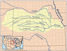 Map of the Kansas River drainage basin showing the Republican River | |
| Location | |
| Country | United States |
| States | Nebraska, Kansas, Colorado |
| Physical characteristics | |
| Source confluence | |
| • location | Haigler, Nebraska |
| • coordinates | 40°01′12″N 101°56′16″W[2] |
| • elevation | 3,253 ft (992 m) |
| Mouth | Kansas River |
• location | Junction City, Kansas |
• coordinates | 39°03′36″N 98°48′05″W[2] |
• elevation | 1,043 ft (318 m) |
| Length | 453 mi (729 km) |
| Basin size | 24,900 sq mi (64,000 km2) |
| Discharge | |
| • location | Junction City about 3 mi (4.8 km) above the mouth[3] |
| • average | 848 cu ft/s (24.0 m3/s) |
| • minimum | 3.2 cu ft/s (0.091 m3/s) |
| • maximum | 33,300 cu ft/s (940 m3/s) |
| Basin features | |
| Tributaries | |
| • left | North Fork Republican River, Frenchman Creek, Red Willow Creek, Medicine Creek |
| • right | Arikaree River, South Fork Republican River, Sappa Creek, Prairie Dog Creek, White Rock Creek |
| Watersheds | Republican-Kansas-Missouri-Mississippi |
Geography
The Republican River is formed by the confluence of the North Fork Republican River and the Arikaree River just north of Haigler in Dundy County, Nebraska. It joins with the South Fork Republican River immediately southeast of Benkelman, Nebraska. All three tributaries originate in the High Plains of northeastern Colorado.[5][6][7] From the confluence, the river flows generally eastward along the southern border of Nebraska, passing through Swanson Reservoir and Harlan County Reservoir before curving southward into the Smoky Hills region of Kansas. The Republican River joins the Smoky Hill River at Junction City, Kansas to form the Kansas River.
Some cities along the river are McCook, Nebraska, Clay Center, Kansas, Concordia, Kansas and Junction City, Kansas. Near Concordia is the Republican River Pegram Truss, a bridge that goes over the Republican River that is listed on the National Register of Historic Places.

History
The river was named after a branch of Pawnee Indians known as "the Republicans".[8]
As early as 1785, the Spanish and French had identified one of the villages of the Pawnee people as aldea de la Republica (little village of the Republic). A French traders' custom was to name rivers for the tribal villages located on their banks.[9] In this way, the north fork of the Kansas River was named Fourche des Republiques or Forks of the Republicans.[1]
The Kitkehahkis Pawnee villages farmed corn, beans, and pumpkin in the fertile Republican valley floor but seasonally left to hunt buffalo in the plains to the west and south.[9]
The Kitkehahkis, or Republican Pawnee, occasionally abandoned and relocated various villages along the Republican River. In 1806, first the Spanish and then the Americans journeyed to the large Kitkehahkis village on Republican River, the Pike-Pawnee Village Site then near the present Guide Rock, Nebraska. Both parties were seeking the tribe's assistance in enforcing competing claims to the Louisiana Territory. Leading the much smaller American expedition, Lieutenant Zebulon Pike convinced the Kitkehahkis to accept the American Flag in place of the Spanish.

In 1853, Fort Riley was established at the junction of the Republican with the Smoky Hill and Kansas Rivers. American settlement of the lower Republican River in began in the 1860s.[10]
Prior to 1864, the Kansas River was publicly navigable under Kansas law. A side-wheel steamboat of 125 tons burden, Financier No. 2, reached the Republican River in 1855 and ascended it some 40 miles.[11] However, in 1864, railroad interests passed a bill through the Kansas Legislature entitled, "An act declaring the Kansas, Republican, Smoky Hill, Solomon, and Big Blue rivers not navigable, and authorizing the bridging of the same." Railroads were thus permitted to bridge or dam the Republican as if it were never declared navigable.[12]
The Kansas Pacific Railway reached the fork of the Republican in 1866, crossing into the Junction City town site. The Junction City and Fort Kearney Railroad was constructed up the valley of the Republican to Clay Center in 1873.[13]

The 1864 law was repealed in 1913;[15] however, under Kansas Law, public access, whether for transport or recreation, is permitted only on publicly owned rivers. The State of Kansas owns only the Kansas and Arkansas Rivers as well as the portion of the Missouri River adjoining the northeastern corner of the state.[16] As such, the limit of public river access is at the mouth of the Republican River. A public boat access ramp was opened on the mouth of the Republican River in 2009 just upstream of the railroad bridge,[17] providing access to the upper end of the Kansas River National Water Trail, a part of the National Water Trail program.[18]
Milford Lake, the largest man-made lake in Kansas, was completed on the Republican in 1967.
Republican River Compact
Allocation of the water from the Republican River is governed through an agreement called the Republican River Compact, involving the states of Nebraska, Kansas and Colorado, as modified by the settlement[19] of a United States Supreme Court case (Kansas vs. Nebraska and Colorado) involving a water-use dispute under the Compact.[20]
Major flooding
July 1902
On July 9, 1902, the river flooded near Concordia, Kansas, breaking a dam and re-routing the river by a quarter-mile (about half a kilometer).[21]
May/June 1935
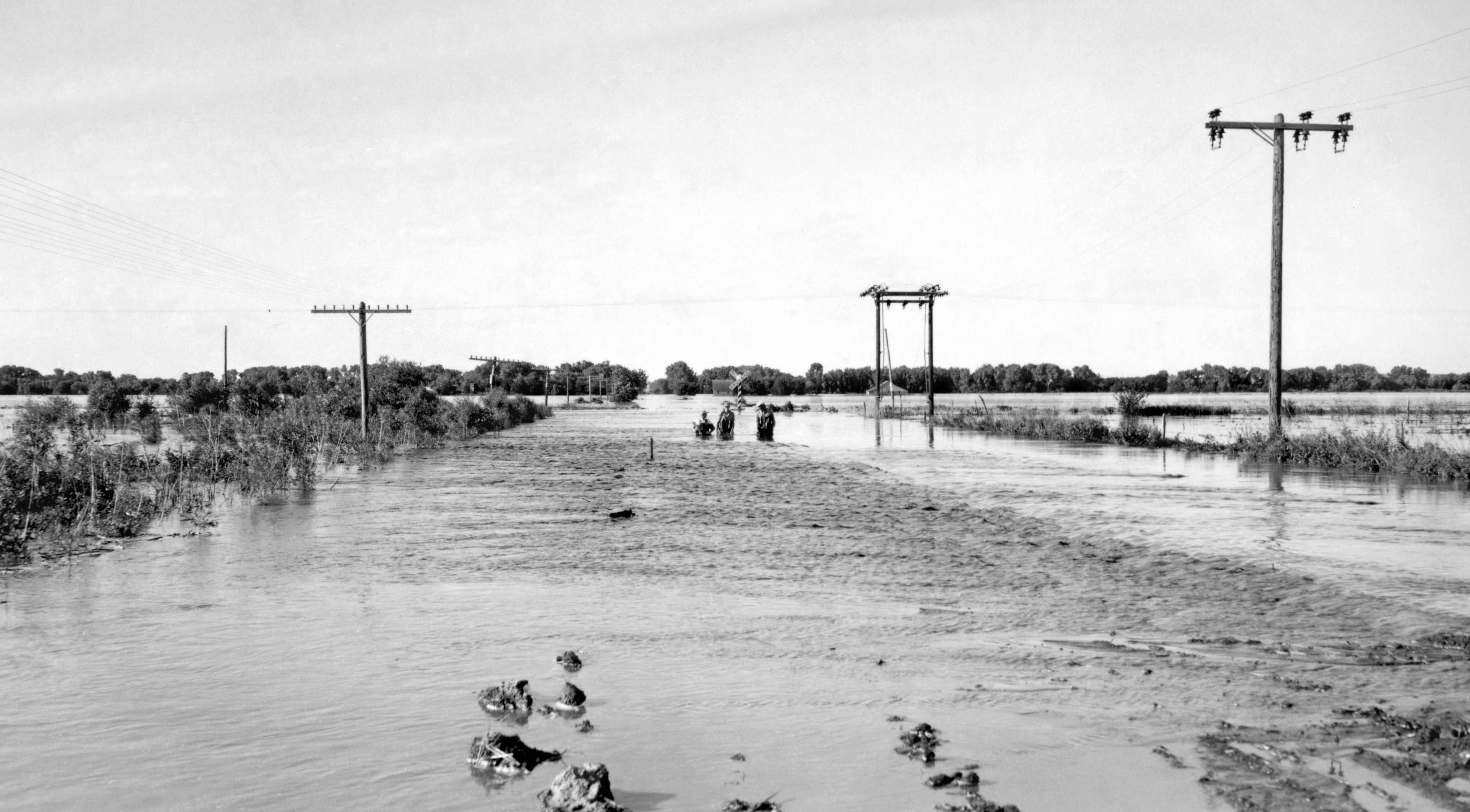
The storm of May 31 and June 1, 1935, (called "Nebraska's Deadliest Flood") dumped an average rainfall of 9 inches (230 mm) on the river's watershed. This storm was also unique in that it moved in the same direction as the drainage basin. As a result, the Frenchman, Red Willow, Medicine, Deer, Muddy, and Turkey creeks all reached their flood peaks at the same time as the crest passed on the Republican River.
According to witness accounts, the roar of the water could be heard coming down the Republican Valley 5 miles (8 km) away. Many survivors also reported that there were two crests - the water came up on May 28, then receded slightly, but the second crest on June 1 greatly exceeded the first. At one point, the water rose 6 feet (1.8 m) in 30 minutes and was 10 to 15 feet (3 to 5 m) higher than the previous record crest. One eyewitness said the water level rose in some places at 10 miles per hour or more.[22] Another account states that the Republican rose 10 feet (3 m) in 12 minutes in McCook, destroying the structures in its path. Water was 20 feet (6 m) deep in some places, and the discharge was 280,000 cubic feet per second (7,900 m3/s), more than 320 times the normal flow today.
Estimates show 113 people killed. From 11,400 to 41,500 head of cattle were killed; one report said that carcasses littering the roads made them impassable. A total of 341 miles (549 km) of highway and 307 bridges were destroyed, and 74,500 acres (301 km2) of farmland were inundated.[23]
See also
- List of Kansas rivers
- List of Nebraska rivers
References
- François-Marie Perrin du Lac (1802), Carte du Missouri : levee ou rectifiée dans toute son etendue, University of Oklahoma Press, retrieved 2017-01-01
- "Republican River". Geographic Names Information System. United States Geological Survey, United States Department of the Interior. Retrieved 2011-02-01.
- "USGS Gage #06857100 on the Republican River at Junction City, KS" (PDF). National Water Information System. U.S. Geological Survey. 1964–2014. Retrieved 2014-01-21.
- U.S. Geological Survey. National Hydrography Dataset high-resolution flowline data. The National Map, accessed March 25, 2011
- "North Fork Republican River". Geographic Names Information System. United States Geological Survey, United States Department of the Interior. Retrieved 2011-02-01.
- "South Fork Republican River". Geographic Names Information System. United States Geological Survey, United States Department of the Interior. Retrieved 2011-02-01.
- "Arikaree River". Geographic Names Information System. United States Geological Survey, United States Department of the Interior. Retrieved 2011-02-01.
- Stewart, George R. (1967) Names on the Land. Boston: Houghton Mifflin Company. p. 223.
- Hyde, George E. (1951). The Pawnee Indians. University of Oklahoma Press. pp. 104, 126, 174–175.
- Isaac O. Savage (1901). A History of Republic County, Kansas. Jones & Chubbic. p. 35. Retrieved 2017-01-08.
- George A. Root (August 1934). "Ferries in Kansas, Part IV, Republican River". Kansas History: A Journal of the Central Plains. 3 (3): 246–288. Retrieved 2017-01-20.
- Perl W. Morgan (1911). "Chapter XII. In the Old Steamboat Days.". History of Wyandotte County Kansas and its people. Vol. 1. The Lewis Publishing Company. Retrieved 2017-01-08.
- "The Junction City and Fort Kearney Railroad". Retrieved 2017-01-08.
- Alex. Gardner, photographer. Crossing of the Republican, in Kansas, 136 miles west of Missouri River. Across the continent on the Kansas Pacific Railroad: route of the 35th parallel. 1869 (approximate).
{{cite AV media}}:|access-date=requires|url=(help) - Edgar Langsdorf (May 1950). "A Review of Early Navigation on the Kansas River". Kansas History: A Journal of the Central Plains. 18 (2): 140–145. Retrieved 2017-01-20.
- "Rivers and Streams Access". Kansas Outdoors. Kansas Department of Wildlife, Parks and Tourism. Retrieved 2017-01-20.
- "The Recreational Kaw". Friends of the Kaw. Retrieved 2017-01-20.
- Kansas River Trail (PDF), Kansas Department of Wildlife, Parks and Tourism, retrieved 2017-01-20
- Final Settlement Stipulation, Kansas v. Nebraska (PDF), December 15, 2002, archived from the original (PDF) on May 28, 2010, retrieved 2012-08-14
- Kansas v. Nebraska, 538 U.S. 720 (2003) (per curiam order approving settlement).
- A Proud Past... A Pictorial History of Concordia, Kansas, by Bell, Rachel Lowrey (1998), Marceline, Missouri: D-Books Publishing.
- The Republican River (2018), ISBN 978-1-7329009-0-5 p. 74
- Nebraska State Historical Society Archived 2011-07-16 at the Wayback Machine "Republican Flood of 1935-Nebraska's Deadliest Flood"
External links
- Republican River Compact Compliance, State of Colorado
- The Republican River, A 2018 survey of the political and social ecology of the Republican River by Denis Boyles
Authority control | |
|---|---|
| General | |
| National libraries | |
На других языках
[de] Republican River
Der Republican River ist ein Fluss in den zentralen Great Plains von Nordamerika. Er fließt 729 km[1] durch die US-Bundesstaaten Nebraska und Kansas.- [en] Republican River
[es] Río Republican
El río Republican (en inglés: Republican River) es un largo río de los Estados Unidos, una de las fuentes del río Kansas, a su vez afluente del río Misuri. Tiene una longitud de 716 km.[1][ru] Репабликан-Ривер
Репа́бликан-Ри́вер[3], Репа́бликан[4] (англ. Republican River) — река на юге штата Небраска и на севере штата Канзас, США. Наряду со Смоки-Хилл является одной из двух составляющих реки Канзас, которая несёт свои воды в реку Миссури. Составляет около 729 км в длину[5]; площадь бассейна — 64 491 км²[1].Другой контент может иметь иную лицензию. Перед использованием материалов сайта WikiSort.org внимательно изучите правила лицензирования конкретных элементов наполнения сайта.
WikiSort.org - проект по пересортировке и дополнению контента Википедии