geo.wikisort.org - River
The North Fork Republican River is a 55.4-mile-long (89.2 km)[2] tributary of the Republican River. It flows eastward from a source in Yuma County, Colorado to just north of Haigler in Dundy County, Nebraska. There it joins with the Arikaree River to form the Republican River.
| North Fork Republican River Wi'hiuniyohe | |
|---|---|
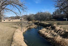
 The river in Wray, Colorado. | |
| Location | |
| Country | United States |
| State | Colorado, Nebraska |
| Physical characteristics | |
| Source | |
| • location | Yuma County, Colorado |
| • coordinates | 39°59′58″N 102°27′14″W |
| • elevation | 3,860 ft (1,180 m) |
| Mouth | Republican River |
• location | Haigler, Nebraska |
• coordinates | 40°01′11″N 101°56′18″W[1] |
• elevation | 3,241 ft (988 m) |
| Length | 55 mi (89 km) |
| Basin size | 5,086 sq mi (13,170 km2) |
| Basin features | |
| Watersheds | North Fork Republican- Republican-Kansas-Missouri- Mississippi |
The North Fork Republican River drains an area of 5,086 square miles (13,170 km2), including 4,449 square miles (11,520 km2), or 87.5%, in eastern Colorado, 575 square miles (1,490 km2), or 11.3%, in southwestern Nebraska, and 62 square miles (160 km2), or 1.2%, in northwestern Kansas.[3]
Use of water from the North Fork Republican River is governed by the Republican River Compact, a water agreement among the U.S. states of Colorado, Nebraska, and Kansas signed on 1942-12-31.
See also
- List of rivers in Colorado
- List of rivers in Nebraska
- Colorado drainage basins
References
- "North Fork Republican River". Geographic Names Information System. United States Geological Survey, United States Department of the Interior. Retrieved 2015-12-07.
- U.S. Geological Survey. National Hydrography Dataset high-resolution flowline data. The National Map, accessed March 29, 2011
- Gustafson, Daniel L. (2003-01-24). "Hydrologic Unit Project". Montana State University, Environmental Statistics Group. Archived from the original on 2012-02-10. Retrieved 2008-02-05.
External links
Другой контент может иметь иную лицензию. Перед использованием материалов сайта WikiSort.org внимательно изучите правила лицензирования конкретных элементов наполнения сайта.
WikiSort.org - проект по пересортировке и дополнению контента Википедии