geo.wikisort.org - River
The Purus River (Portuguese: Rio Purus; Spanish: Río Purús) is a tributary of the Amazon River in South America. Its drainage basin is 371,042 km2 (143,260 sq mi), and the mean annual discharge is 11,207 m3/s (395,800 cu ft/s). The river shares its name with the Alto Purús National Park as well as the Purús Province (and its conformed Purús District), one of the four provinces of Peru in the Ucayali Region.
This article needs additional citations for verification. (November 2014) |
| Purus River | |
|---|---|
 Purus River | |
 Map of the Amazon Basin with the Purus River highlighted | |
| Location | |
| Country | Brazil, Peru |
| Physical characteristics | |
| Source | Confluence of Cujar and Curiuja rivers |
| • location | Ucayali Region, Peru |
| • coordinates | 10°44′56″S 71°47′14″W |
| • elevation | 330 m (1,080 ft) |
| 2nd source | Most distant source approximate area. Headwaters of Cujar River. |
| • location | Ucayali Region, Peru |
| • coordinates | 10°42′52″S 72°26′44″W |
| • elevation | 520 m (1,710 ft) |
| Mouth | |
• coordinates | 3°41′35″S 61°28′12″W |
| Length | 3,382 km (2,101 mi) |
| Basin size | 371,042 km2 (143,260 sq mi) 378,762.4 km2 (146,241.0 sq mi)[1] |
| Discharge | |
| • location | Confluencia of Solimões, Amazonas State (near mouth) |
| • average | 10,970 m3/s (387,000 cu ft/s) 11,207 m3/s (395,800 cu ft/s)[2] |
| Discharge | |
| • location | Arumã-Jusante, Amazonas State (359,853 km2 (138,940 sq mi) |
| • average | (Period of data: 1970-1996)10,469 m3/s (369,700 cu ft/s)[3] |
| Discharge | |
| • location | Lábrea, Amazonas State (Basin size: 220,351 km2 (85,078 sq mi) |
| • average | (Period of data: 1970-1996)5,569 m3/s (196,700 cu ft/s)[4] |
| Basin features | |
| Tributaries | |
| • left | Inauini, Pauini, Tapauá |
| • right | Chandless, Iaco, Acre, Sepatini, Ituxi, Mucuim, Itaparaná |
Geography
The Purus River rises in Peru. It defines the boundary between Peru and Brazil in the centre of the state of Acre, then runs for a short distance along the boundary of the 231,555 hectares (572,180 acres) Santa Rosa do Purus National Forest, a sustainable use conservation unit created in 2001 after it is joined by the Santa Rosa River. It then flows north east through Manoel Urbano[5] It runs through a continuous forest at the bottom of the great depression, lying between the Madeira River, which skirts the edge of the Brazilian sandstone plateau, and the Ucayali River, which hugs the base of the Andes.[citation needed]
In the state of Amazonas the river runs through the 133,637 hectares (330,220 acres) Arapixi Extractive Reserve, created in 2006 and past the town of Boca do Acre at the end of the BR-317 highway.[6] Further down, it forms the west boundary of the 256,000 hectares (630,000 acres) Purus National Forest, created in 1988.[7] From the town of Pauini down to the town of Lábrea the river is bordered by the 604,209 hectares (1,493,030 acres) Médio Purus Extractive Reserve, created in 2008.[8] Below this it runs through the 197,986 hectares (489,230 acres) Canutama Extractive Reserve along the stretch between the towns of Lábrea and Canutama.[9] In the lowest reaches the river flows through the 1,008,167 hectares (2,491,230 acres) Piagaçu-Purus Sustainable Development Reserve, established in 2003, which holds a large part of its floodplain.[10] It enters the Amazon River west of the Madeira River, which it parallels as far south as the falls of the latter stream.[citation needed]
William Chandless found its elevation above sea level to be only 107 feet (33 m) 590 miles (950 km) from its mouth. It is one of the most crooked streams in the world, and its length in a straight line is less than half of its length following its curves. It is practically only a drainage ditch for the half-submerged, lake-flooded district it crosses.[citation needed] Its width is very uniform for 1000 miles (1600 km) up, and for 800 miles (1300 km) its depth is never less than 45 feet (15 m).[citation needed]
Biodiversity
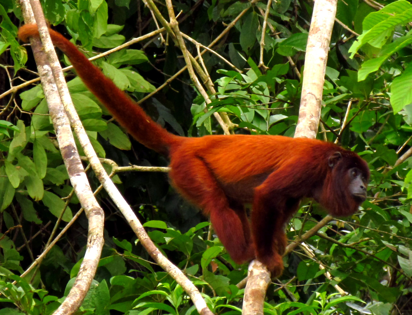
The Purús red howler (Alouatta puruensis) is a species of howler monkey native to Brazil, Peru and north of Bolivia.[11] Peckoltia brevis, a kind of catfish, is found in the middle and upper Amazon within the Purus river basin.[12][13]
Most of the central and lower sections of the river flow through the Purus várzea ecoregion.[14] In the municipality of Tapauá, Amazonas, the river flows through the 233,864 hectares (577,890 acres) Abufari Biological Reserve, a strictly protected area.[15]
Earthworks discovery
In 2008, a previously unknown pre-Columbian civilization was discovered in the upper region of the river close to the Bolivian border. After much of the forest in the region was cleared for agricultural use, satellite pictures revealed the remains of large geometric earthworks.[16]
See also
- Amazon rainforest
- Esperanza, Ucayali
- Brazilian Amazon
- Peruvian Amazon
- River basin
- Catauxi
References
- "Rivers Network". 2021.
- "PLANO ESTADUAL DE RECURSOS HÍDRICOS DO AMAZONAS, (PERH/AM) - RT 03 - DIAGNÓSTICO, PROGNÓSTICO E CENÁRIOS FUTUROS DO RECURSOS HÍDRICOS DO ESTADO - TOMO III" (PDF). Jan 2019.
- Michael, T. Coe; Marcos, Heil Costa; Aurélie, Botta; Charon, Birkett (23 Aug 2002). "Long-term simulations of discharge and floods in the Amazon Basin".
- Michael, T. Coe; Marcos, Heil Costa; Aurélie, Botta; Charon, Birkett (23 Aug 2002). "Long-term simulations of discharge and floods in the Amazon Basin".
- FLONA de Santa Rosa do Purus (in Portuguese), ISA: Instituto Socioambiental, retrieved 2016-06-21
- RESEX Arapixi (in Portuguese), ISA: Instituto Socioambiental, retrieved 2016-09-08
- FLONA do Purus (in Portuguese), ISA: Instituto Socioambiental, retrieved 2016-09-08
- RESEX Médio Purus (in Portuguese), ISA: Instituto Socioambiental, retrieved 2016-09-03
- RESEX Canutama (in Portuguese), ISA: Instituto Socioambiental, retrieved 2016-09-02
- RDS Piagaçu-Purus (in Portuguese), ISA: Instituto Socioambiental, retrieved 2016-08-20
- Cornejo, F.M.; Boubli, J.P.; Alves, S.L.; Bicca-Marques, J.C.; Cortés-Ortiz, L.; Calouro, A.M.; de Melo, F.R. (2021). "Alouatta puruensis". IUCN Red List of Threatened Species. 2021: e.T136787A190430767. doi:10.2305/IUCN.UK.2021-1.RLTS.T136787A190430767.en. Retrieved 11 November 2021.
- "Planet catfish".
- "Fish Base".
- "Purus varzea", Global Species, Myers Enterprises II, retrieved 2017-03-15
- Unidade de Conservação: Reserva Biológica do Abufari (in Portuguese), MMA: Ministério do Meio Ambiente, retrieved 2016-04-24
- Martti Pärssinen, Denise Schaan, Alceu Ranzi: Pre-Columbian geometric earthworks in the upper Purús: a complex society in western Amazonia. Antiquity, Volume 83, 2009, p. 1084–1095
- Purus River. (2010). In Encyclopædia Britannica. Retrieved January 12, 2010, from Encyclopædia Britannica Online.
External links
- Map of Amazon State with Purus River, Brazilian Ministry of Transport
- "Peru Preserves Biodiversity in Vast New Park". Environment News Service. 1 April 2005. Retrieved 5 November 2014.
- "Alto Purús National Park". Enjoy Peru. Archived from the original on 17 May 2008. Retrieved 5 November 2014.
Authority control | |
|---|---|
| General |
|
| National libraries | |
На других языках
[de] Rio Purus
Der 3210 Kilometer lange Rio Purus (portugiesische Schreibweise; im Spanischen Río Purús) ist ein rechter Nebenfluss des Amazonas, des größten Stromes von Südamerika.- [en] Purus River
[es] Río Purús
El río Purús es un gran río localizado en Perú y Brasil, uno de los principales afluentes del río Amazonas. Es un río muy sinuoso, con agua blanca y exuberante naturaleza. Es el último gran afluente de la margen derecha del río Solimões (nombre dado solamente en Brasil al Río Amazonas antes de la reunión con el río Negro). Debido a su alta riqueza de especies y su alta productividad, está sufriendo una gran explotación humana: pesca, caza, tala y agricultura.[it] Purus
Il Purus (Rio Purus in portoghese, Río Purús in spagnolo) è un fiume dell'America meridionale, che scorre per 3.211 km verso nord-est per confluire infine nel Rio delle Amazzoni. Ha un bacino idrografico di 63.166 km² e una portata media di 8.400 m³/s.[ru] Пурус
Пуру́с[1] (порт. Rio Purus) — река, правый приток Амазонки. Длина около 3200[2] км. Площадь бассейна 365 000[2] км², средний расход воды составляет 8400 — 12 600[3] м³/с. Ширина Пуруса в нижнем течении до 1200 м.Другой контент может иметь иную лицензию. Перед использованием материалов сайта WikiSort.org внимательно изучите правила лицензирования конкретных элементов наполнения сайта.
WikiSort.org - проект по пересортировке и дополнению контента Википедии