geo.wikisort.org - River
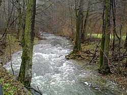
Punkva is a 29 km (18 mi) long river in South Moravia, Czech Republic. It is a Subterranean river in the Moravian Karst and a left tributary of the Svitava. It is the longest underground river in the Czech Republic.
| Punkva | |
|---|---|
 Punkva in Moravian Karst | |
| Physical characteristics | |
| Source | Luha |
| • location | A spring in the forest between Suchý and Protivanov |
| • coordinates | 49°29′32″N 16°47′28″E |
| • elevation | 698 m (2,290 ft) |
| Mouth | Svitava |
• location | Blansko |
• coordinates | 49°20′54″N 16°39′6″E |
• elevation | 267 metres (876 ft) |
| Length | 29 km (18 mi) |
| Basin size | 170 km2 (66 sq mi) |
| Discharge | 0.96 m3/s (34 cu ft/s) |
| Basin features | |
| Progression | Svitava→ Svratka→ Thaya→ Morava→ Danube→ Black Sea |
The river forms underground as a confluence of two other underground streams. Sloupský potok is the large of the two and enters the underground within the Sloup-Šošuv cave system near Sloup. Its own source is the Luha, which is therefore Punkva's ultimate source. The other source is Bílá Voda, which sinks near Nová Rasovna cave by Holštejn.

The river flows into the Macocha Gorge and forms a small lake at the bottom. The water reenters the underground thereafter and forms the Punkva Caves, which are a tourist attraction attached to Macocha. Tourists are taken by boat through a part of the system.
After leaving the caves Punkva flows through a valley and several fish ponds. Multiple small local streams are its right tributaries. It enters the Svitava on the southern side of Blansko and its flow joins the Danube watershed.
External Links
На других языках
[de] Punkva
Punkva deutsch Punkwa ist ein Fluss im Okres Blansko in Tschechien. Er ist 29 Kilometer lang, das Einzugsgebiet umfasst 170 km². Der kleine Fluss ist überregional bekannt geworden, da ein Teil der Flussstrecke durch den Untergrund des Mährischen Karstes verläuft.- [en] Punkva
[ru] Пунква
Пу́нква[1][2] (чеш. Punkva) — река на востоке Чехии. Течёт по территории района Бланско в Южно-Моравском крае и района Простеёв в Оломоуцком крае. Левый приток нижнего течения Свитавы[3]. Самая длинная подземная река Чехии[4].Другой контент может иметь иную лицензию. Перед использованием материалов сайта WikiSort.org внимательно изучите правила лицензирования конкретных элементов наполнения сайта.
WikiSort.org - проект по пересортировке и дополнению контента Википедии