geo.wikisort.org - River
The Pastaza River (Spanish: Río Pastaza, formerly known as the Sumatara[6]) is a large tributary to the Marañón River in the northwestern Amazon Basin of South America.[7]
| Pastaza River | |
|---|---|
 The Pastaza at Mera, Pastaza Province | |
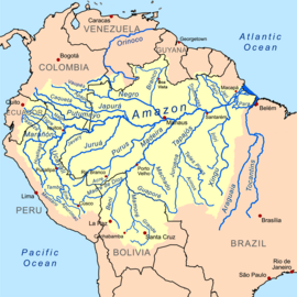 Amazon Basin with Pastaza River in the far west | |
| Native name | Río Pastaza (Spanish) |
| Location | |
| Countries |
|
| Physical characteristics | |
| Source | Cotopaxi Province |
| • coordinates | 0°40′0″S 78°27′0″W |
| • elevation | 4,570 m (14,990 ft)[1] |
| Mouth | Marañón River |
• coordinates | 4°54′29″S 76°24′32″W |
• elevation | 120 m (390 ft)[2] |
| Length | 710 km (440 mi)[1] |
| Basin size | 39,504 km2 (15,253 sq mi)[3] |
| Discharge | |
| • location | Confluence of Marañón (near mouth) |
| • average | 2,769 m3/s (97,800 cu ft/s)[4] |
Ramsar Wetland | |
| Official name | Complejo de humedales del Abanico del río Pastaza |
| Designated | 5 June 2002 |
| Reference no. | 1174[5] |
It has its headwaters in the Ecuadorian province of Cotapaxi, flowing off the northwestern slopes of the volcano Cotopaxi and known as the Patate River. The Patate flows south and in Tungurahua Province it is joined by the Chambo River just upstream from the town of Baños de Agua Santa just north of the volcano Mount Tungurahua and becomes the Pastaza.[8][9] Seven kilometers east of Baños, it is dammed for the Agoyán hydroelectric project, which has created a silty lagoon by the village of La Cieniga.[9] The Agoyán dam was placed in that location specifically to leave the famous Falls of Agoyán, about 5 km further downstream, intact. After the waterfall the river enters a gorge where there is very fast whitewater with class-4 rapids; it is often used for whitewater rafting although it is not considered to be of the same quality as the Tena River and is therefore less popular for the sport.[10]
From the junction with the Chambo, the Pastaza flows almost due east for about 275 kilometres (171 mi) where it then turns south-east, as it is joined by the Topo River.[11] The Troncal Amazonas highway parallels the river from Baños to Puyo, passing through seven tunnels, and four major waterfalls that are touristic destinations for many Ecuadorians (Agoyán and Pailón del Diablo being the most popular.) Just past the town of Santa Inez, the Pastaza River crosses into the province of Pastaza, where it forms the boundary between that province and Morona-Santiago. At the town of Mera, shortly before reaching Puyo, the river exits the mountains and flows into a wide valley, becoming wider and shallower.[12] After Shell the river becomes braided and meanders, leaving oxbows and sloughs along its route across the Amazonian floodplain.
After cutting through Ecuador, the Pastaza passes into Peru at the village of Hito Zoilaluz on Isla Zoilaluz[13] and flows south into the Marañón River near Puerto Industrial.[2]
Tributaries
The Pastaza has numerous tributaries, both above and below the hydroelectric dam. These contribute to its rapid flow and to its tendency to flood. On the highway side of the Pastaza, a tributary river occurs about every 3–4 km for a stretch of about 50 km; on the opposite bank, the number of tributaries is slightly lower. The major tributaries are the Chambo, Bobonaza, and Huasaga,[7] also important are the Ambato, the Pindo, and the Puyo.
Economy

There are no major fisheries on the Pastaza River - it is primarily used as a means of transport by canoe.[6] Its rise and fall are rapid and uncertain, and it is shallow and full of sandbanks and snags.[14] Flooding occurs seasonally.[6]
Bridges
In Ecuador, there are very few bridges across the Pastaza. The most significant ones are in Tungurahua province - namely a large span over the exact point of headwaters, just north of Baños, and the secondary span created by the Agoyán dam. After this, bridges tend to be of the suspension type, suitable for foot or small vehicle passage only. However, it is notable that the Pastaza can be forded during the dry season in a 4x4 truck, going across the floodplains below the town of Mera.
See also
References and notes
- Ziesler, R.; Ardizzone, G.D. (1979). "Amazon River System". The Inland waters of Latin America. Food and Agriculture Organization of the United Nations. ISBN 92-5-000780-9. Archived from the original on 8 November 2014.
- Topographic map San Isidro, Peru, Series J632, Sheet 1661, 1:100,000 Instituto Geografico Nacional (IGN), Lima, Peru, October 1993, reprinted by the U.S. National Imagery and Mapping Agency
- "Oficina Nacional de Evaluación de Recursos Naturales (ONERN)". 1980.
- "Oficina Nacional de Evaluación de Recursos Naturales (ONERN)". 1980.
- "Complejo de humedales del Abanico del río Pastaza". Ramsar Sites Information Service. Retrieved 25 April 2018.
- Enock, Charles Reginald (1914) Ecuador: its ancient and modern history, topography and natural resources, industries and social development Charles Scribner's sons, New York, pages 177–178, OCLC 2453173
- Ziesler, R. and G.D. Ardizzone, G.D. (1979) "Amazon System" Las Aguas Continentales de America Latina / The Inland Waters of Latin America (COPESCAL Technical Paper No. 1) Fisheries and Aquaculture Department, Food and Agriculture Organization of the United Nations (FAO), Rome, ISBN 92-5-000780-9, in English and Spanish
- Instituto Geografico Militar del Ecuador, Mapa Tungurahua 50,000:1
- Topographic map Baños, Ecuador, Series J721, Sheet 3989 IV, 1:50,000 Instituto Geográfico Militar (IGM), Quito, Ecuador, September 2000, reprinted by the U.S. National Imagery and Mapping Agency
- Guia Turistica del Tungurahua, Ministerio de Turismo Ecuador
- Topographic map Rio Negro, Ecuador, Series J721, Sheet 3990 II, 1:50,000 Instituto Geográfico Militar (IGM), Quito, Ecuador, June 1996, reprinted by the U.S. National Imagery and Mapping Agency
- Topographic map Mera, Ecuador, Series J721, Sheet 3989-I, 1:50,000, Instituto Geográfico Militar (IGM), Quito, Ecuador, 1989, a reduced image is available from IGM
- Topographic map Checherta, Peru, Series J632, Sheet 1565, 1:100,000 Instituto Geografico Nacional (IGN), Lima, Peru, June 1995, reprinted by the U.S. National Imagery and Mapping Agency
- Chisholm, Hugh, ed. (1911). . Encyclopædia Britannica. Vol. 1 (11th ed.). Cambridge University Press. p. 788.
На других языках
[de] Río Pastaza
Der Río Pastaza (früher Río Sumatara) ist ein bedeutender Zufluss des Amazonas, der in den ecuadorianischen Anden entsteht und auf peruanischem Territorium in den Marañón mündet. Der Río Pastaza ist insgesamt gut 600 km lang, einschließlich des rechten Quellflusses Río Chambo beträgt die Gesamtlänge 740 km.- [en] Pastaza River
[it] Rio Pastaza
Il Rio Pastaza, anticamente conosciuto come Sumatara, è un fiume sudamericano che scorre nei territori di Ecuador e Perù, affluente del Marañón, a sua volta un importante affluente del Rio delle Amazzoni. Ha una lunghezza di 710 km, di cui 370 nel territorio amazzonico peruviano, nella Regione di Loreto. Nasce alla confluenza dei fiumi Patate e Chambo, ai piedi del vulcano Tungurahua nella provincia omonima, in Ecuador, anche se le sue origini derivano probabilmente dal disgelo del Cotopaxi, dove nasce il Rio Callo[1].[ru] Пастаса (река)
Пастаса (исп. Río Pastaza) — река в Южной Америке, в северо-западной части бассейна Амазонки. Крупнейший приток реки Мараньон[1]. Длина — 710[1] км.Другой контент может иметь иную лицензию. Перед использованием материалов сайта WikiSort.org внимательно изучите правила лицензирования конкретных элементов наполнения сайта.
WikiSort.org - проект по пересортировке и дополнению контента Википедии