geo.wikisort.org - River
Palouse Falls is a waterfall on the Palouse River, about 4 mi (6 km) upstream of the confluence with the Snake River in southeast Washington, United States. The falls are 200 ft (61 m) in height.[2] The falls consist of an upper fall with a drop around 20 ft (6.1 m), which lies 1,000 ft (305 m) north-northwest of the main drop, and a lower fall, with a drop of 200 ft (61 m). It is in the 94-acre (38 ha) Palouse Falls State Park.
| Palouse Falls | |
|---|---|
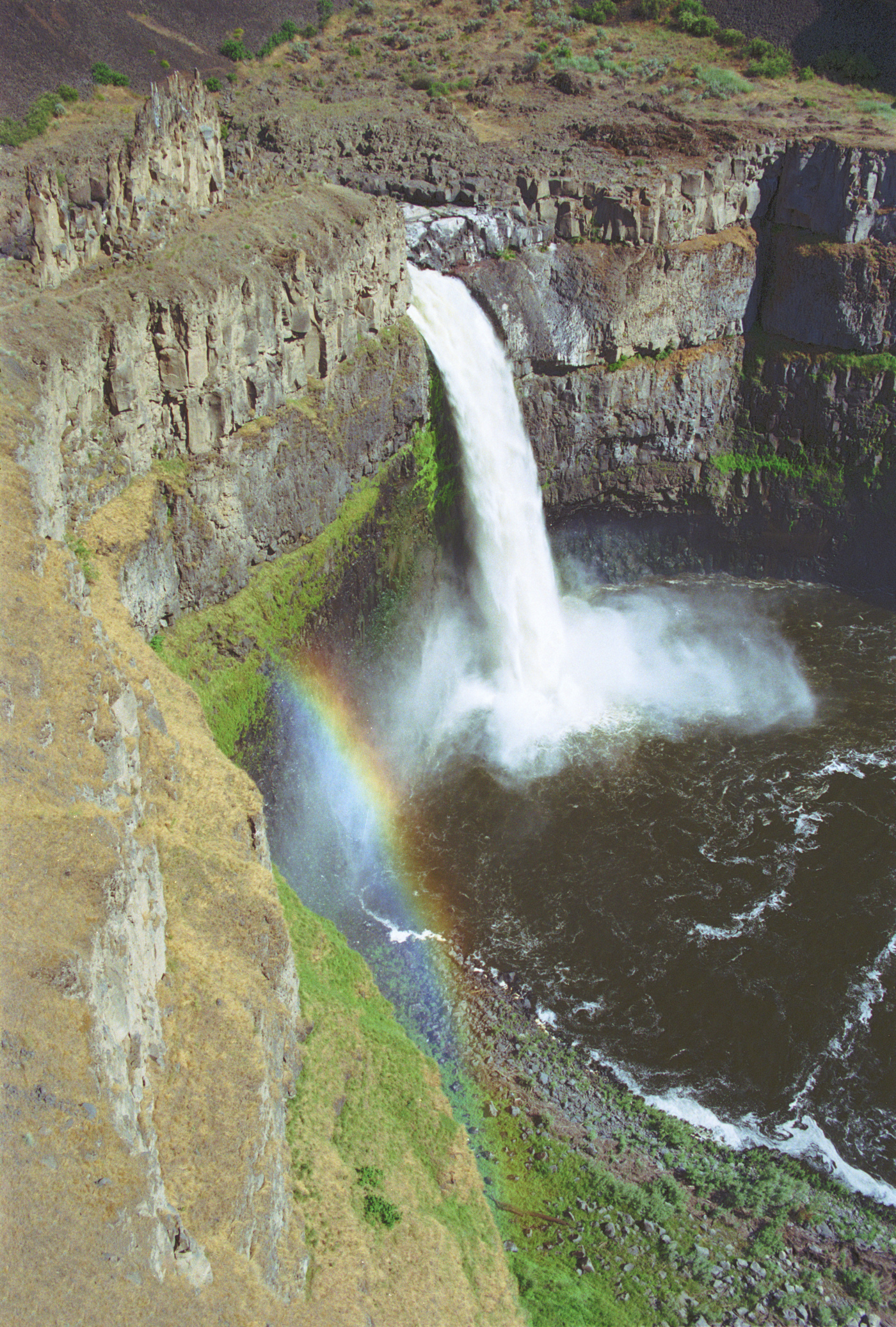 Palouse Falls during high flow, viewed from the west side of the canyon | |
 | |
| Location | Franklin / Whitman counties, Washington, United States |
| Coordinates | 46°39′49″N 118°13′25″W[1] |
| Elevation | 725 feet (221 m) |
| Total height | 200 feet (61 m) |
| Palouse Falls State Park | |
|---|---|
 | |
| Location | Washington, United States |
| Area | 94 acres (38 ha) |
| Elevation | 784 ft (239 m)[1] |
| Established | 1951 |
| Operator | Washington State Parks and Recreation Commission |
| Website | Palouse Falls State Park |
Geology
The canyon at the falls is 115 m (377 ft) deep, exposing a large cross-section of the Columbia River Basalt Group. These falls and the canyon downstream are an important feature of the channeled scablands created by the great Missoula floods that swept periodically across eastern Washington and across the Columbia River Plateau during the Pleistocene epoch.[3][4][5]
The ancestral Palouse River flowed through the currently dry Washtucna Coulee to the Columbia River. The Palouse Falls and surrounding canyons were created when the Missoula floods overtopped the south valley wall of the ancestral Palouse River, diverting it to the current course to the Snake River by erosion of a new channel.[3][6]
The area is characterized by interconnected and hanging flood-created coulees, cataracts, plunge pools, kolk-created potholes, rock benches, buttes, and pinnacles typical of scablands. Palouse Falls State Park is located at the falls, protecting this part of the uniquely scenic area.[5]
 |
|---|
Economic proposals
In 1984, the Franklin County Public Utility District proposed a 98-foot-high (30 m) dam be constructed upstream of the falls, allowing for a significant hydraulic head for hydroelectric power generation. This would have provided over one-third of the county's power and would have reduced ratepayer charges substantially. However, the majority of the ratepayers declined to approve the investment, preserving this geologically significant feature.[3]
Palouse Falls State Park
The falls are included in Washington's Palouse Falls State Park, which provides access to the falls and has displays explaining the region's unique geology, as well as its historical ties (the Palouse Indians and the Mullan Road both took advantage of the easy access to the plateau in the vicinity of the falls).[2] The park provides a viewpoint facing Palouse Falls that is a short walk from the parking area, campground, and picnic area. A larger trail system is being developed by the parks department.[7] The state park was created in 1951 following the contribution of several parcels of land by multiple donors. The park has a short, ADA-accessible trail with falls overlook and facilities for picnicking and tent camping.
Kayaking
On April 21, 2009, Tyler Bradt ran the falls in a kayak, setting an unofficial world record for the highest waterfall run. Bradt's media agent released the video footage of him dropping over the falls to Sports Illustrated, which carried it on its website.[8][9] The magazine carried a two-page photo of the feat in its May 18 issue. The photos were also reproduced in Spain's Hola magazine's international issue of September 23, 2009.
Height of the falls
As a result of the unofficial world record for the highest waterfall run, questions were raised about the correct height of the main drop for the falls. In the interest of claiming a world record, Bradt's team measured the falls and determined the height was 186 ft (57 m) from the top pool immediately above the main drop to the plunge pool immediately below. The Spokesman-Review inquired with Washington state officials and determined that the previous height measurement was performed in 1945 using earlier techniques; the state was not prepared to perform an updated measurement using laser surveying equipment. However, a Whitman College geology professor led a team of students who determined:[10]
- The height of the plunge pool and the top pool both vary with river flows, but not uniformly.
- The flow peak for 2009 was 8,300 cu ft/s (240 m3/s) on January 9 - at that time the river top pool elevation was 12 ft (3.7 m) higher than when the measurements were made on August 18.
- The estimated plunge pool elevation difference between January and August was 7 ft (2.1 m).
- Hence, a 5-foot (1.5 m) variability was seen in the height of falls over this period.
- The likely height of the falls at the main drop during the highest waterfall record attempt was between 175 and 180 ft (55 m).
Official state waterfall
On February 12, 2014, the Washington House of Representatives passed HB 2119 unanimously to make Palouse Falls the official state waterfall in Washington.[11] The proposal for the bill originated when a group of elementary school students in the nearby town of Washtucna lobbied the state legislature.[12]
References
- "Palouse Falls". Geographic Names Information System. United States Geological Survey, United States Department of the Interior. Retrieved 11 July 2011.
- "Palouse Falls State Park". Washington State Parks. Retrieved 16 May 2021.
- Carson, Robert J.; Pogue, Kevin R. (1996). Flood Basalts and Glacier Floods:Roadside Geology of Parts of Walla Walla, Franklin, and Columbia Counties, Washington. Washington State Department of Natural Resources (Washington Division of Geology and Earth Resources Information Circular 90). ISBN none.
- Alt, David (2001). Glacial Lake Missoula & its Humongous Floods. Mountain Press Publishing Company. ISBN 0-87842-415-6.
- Bjornstad, Bruce (2006). On the Trail of the Ice Age Floods: A Geological Guide to the Mid-Columbia Basin. Keokee Books; Sand Point, Idaho. ISBN 978-1-879628-27-4.
- Alt, David & Hyndman, Donald (1984). Roadside Geology of Washington. Mountain Press Publishing Company. ISBN 0-87842-160-2.
- "Palouse Falls Viewpoint and Campground in Palouse Falls State Park". hikespeak.com. Hikespeak. Retrieved December 15, 2018.
- "Fall Guy: Paddling Over Palouse Falls". Sports Illustrated. 13 May 2009. Archived from the original on May 18, 2009. Retrieved 15 May 2009.
- Robinson, Laurie; Oregonian, The (May 30, 2009). "Portland kayaker witnesses Palouse Falls descent". oregonlive. Retrieved June 8, 2009.
- Landers, Rich (12 September 2009). "Measuring up to Palouse Falls". quoted by tricityherald.com from The Spokesman-Review. tricityherald.com. Archived from the original on 5 February 2013. Retrieved 12 September 2009.
- "Chapter 1.20 RCW". Secretary of State of Washington. Retrieved December 19, 2009.
- "House passes Palouse Falls bill". The Spokesman-Review. Retrieved 12 February 2014.
External links
Ice Age Floods National Geologic Trail in the Pacific Northwest | ||
|---|---|---|
| Ice Age Glacial Floods |
|  |
| Glacial Lakes |
| |
| Temporary Lakes |
| |
| Ice Age Floods Glacial Residue |
| |
| Ice Age Floods Erosion & Deposition Features |
| |
| Related contemporaneous events |
| |
Protected areas of Washington | |||||||||||||||||||||||||
|---|---|---|---|---|---|---|---|---|---|---|---|---|---|---|---|---|---|---|---|---|---|---|---|---|---|
| Federal |
| ||||||||||||||||||||||||
| State |
| ||||||||||||||||||||||||
| Other |
| ||||||||||||||||||||||||
| |||||||||||||||||||||||||
На других языках
- [en] Palouse Falls
[es] Catarata Palouse
La catarata Palouse (en inglés, Palouse Falls) es un salto de agua situado en el curso del río Palouse, unos 6 km aguas arriba de la confluencia con el río Snake, en el sureste del estado de Washington, Estados Unidos. La catarata, del tipo zambullida o en picado (plunge), tiene una altura de 60 m.[1] Un primer salto, con unos 6,0 m de desnivel, está situado unos 300 m al norte-noroeste del salto principal.Другой контент может иметь иную лицензию. Перед использованием материалов сайта WikiSort.org внимательно изучите правила лицензирования конкретных элементов наполнения сайта.
WikiSort.org - проект по пересортировке и дополнению контента Википедии