geo.wikisort.org - River
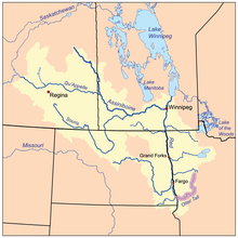
The Otter Tail River (Ojibwe: Nigigwaanowe-ziibi) is a 192-mile-long (309 km)[3] river in the west-central portion of the U.S. state of Minnesota. It begins in Becker County, 40 miles (64 km) southwest of Bemidji. It then flows through a number of lakes and cities in Minnesota, including Many Point Lake, Chippewa Lake, Height of Land Lake, Frazee, the Pine lakes, Rush Lake, Otter Tail Lake and Ottertail, West Lost Lake, Fergus Falls, and Orwell Lake.[2]
| Otter Tail River | |
|---|---|
 Sunset on the Otter Tail River near Otter Tail Lake and Ottertail, Minnesota | |
 Mouth of the Otter Tail River | |
| Native name | Nigigwaanowe-ziibi (Ojibwe) |
| Location | |
| Country | United States |
| State | Minnesota |
| Counties | Wilkin, Otter Tail, Becker |
| Physical characteristics | |
| Source | |
| • location | Round Lake |
| • coordinates | 47°01′39″N 95°32′40″W |
| • elevation | 1,494 feet (455 m)[1] |
| Mouth | Red River of the North |
• coordinates | 46°15′51″N 96°35′52″W |
• elevation | 951 feet (290 m)[2] |
| Length | 192 mi-long (309 km) |
At its mouth, it joins with the Bois de Sioux River to form the Red River between Breckenridge, Minnesota and Wahpeton, North Dakota.[4] The Red River is the Minnesota–North Dakota boundary from this point onward to the Canada–United States border. Waters of the Red River watershed ultimately flow north into Hudson Bay.[5]
Between 1909 and 1925, the privately owned Otter Tail Power Company built five dams on the Otter Tail River. They are Dayton Hollow (1909), Hoot Lake (1914), Pisgah (1918), Central / Wright (built 1871, rebuilt 1922), and Taplin Gorge (1925).
The Otter Tail River is the third longest river totally within the state of Minnesota and the ninth longest river that flows for some portion through the state.[citation needed]
See also
References
- Many Point Lake, MN, 7.5 Minute Topographic Quadrangle, USGS, 1969 (1971 rev.)
- U.S. Geological Survey Geographic Names Information System: Otter Tail River
- U.S. Geological Survey. National Hydrography Dataset high-resolution flowline data. The National Map, accessed June 8, 2011
- Wahpeton, Minn.-N. Dak., 7.5 Minute Topographic Quadrangle, USGS, 1964 (1979 rev.)
- "Otter Tail State Water Trail Map" (PDF). Minnesota Department of Natural Resources. Retrieved April 27, 2021.
Authority control | |
|---|---|
| General |
|
| Other | |
На других языках
[de] Otter Tail River
Der Otter Tail River ist ein Fluss inmitten des US-Bundesstaates Minnesota. Er entspringt im Clearwater County in der Nähe von Bemidji. Er durchfließt dann eine Reihe von Seen und Städten in Minnesota. Dazu gehören Elbow Lake, Many Point Lake, Chippewa Lake, Height of Land Lake, Frazee, Little Pine Lake, Big Pine Lake, Rush Lake, Otter Tail Lake und Ottertail, West Lost Lake, Fergus Falls und Orwell Lake. Er bildet gemeinsam mit dem Bois de Sioux River nach deren Zusammenfluss den Red River of the North.- [en] Otter Tail River
[ru] Оттер-Тейл
О́ттер-Тейл (англ. Otter Tail) — река длиной 309 км на западе центральной части штата Миннесота, США. Протекает через округа Уилкин, Оттер-Тейл и Бекер[1]. Оттер-Тейл течёт в юго-западном направлении к границе штатов Миннесота и Северная Дакота до слияния с рекой Буа-де-Сиу в Ред-Ривер около Брекенриджа[2].Другой контент может иметь иную лицензию. Перед использованием материалов сайта WikiSort.org внимательно изучите правила лицензирования конкретных элементов наполнения сайта.
WikiSort.org - проект по пересортировке и дополнению контента Википедии