geo.wikisort.org - River
The Ofanto (Italian pronunciation: [ˈɔːfanto]), known in ancient times as Aufidus or Canna,[1] is a 170-kilometre (110 mi) river in southern Italy that flows through the regions of Campania, Basilicata, and Apulia, into the Gulf of Manfredonia near Barletta.
This article may be expanded with text translated from the corresponding article in Italian. (July 2012) Click [show] for important translation instructions.
|
| Ofanto | |
|---|---|
 | |
 | |
| Location | |
| Country | Italy |
| Physical characteristics | |
| Source | |
| • location | near Nusco |
| • elevation | 715 m (2,346 ft) |
| Mouth | Adriatic Sea |
• location | Gulf of Manfredonia |
• coordinates | 41.3592°N 16.1976°E |
• elevation | 0 m (0 ft) |
| Length | 170 km (110 mi) |
| Basin size | 2,780 km2 (1,070 sq mi) |
| Discharge | |
| • average | 15 cubic metres per second (530 cu ft/s) |
Geography
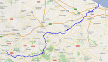
The river's source is on the Irpinia Plateau, at 715 metres (2,346 ft) above sea level, near Nusco and Torella dei Lombardi, in the province of Avellino. From there it runs southeast near Lioni before flowing into Lago di Conza, an artificial lake.[2] The river then forms the border between the province of Avellino and the province of Potenza except for a small extension of the province of Avellino near Calitri. The Atella flows into the Ofanto near this point as a right tributary of the river. The river curves north and flows near Monteverde before forming the border between the province of Foggia and the province of Potenza. It then curves east for a distance and a right tributary, the Olivento, flows into it in this area. The river curves northeast and then forms the border between the province of Foggia and the province of Barletta-Andria-Trani. The river flows near Posta Piana, Canosa di Puglia, San Ferdinando di Puglia, and Cannae before entering the Gulf of Manfredonia between Margherita di Savoia and Barletta. The Locone enters the Ofanto south of Cerignola as a right tributary of the river. At the end of its journey to the sea, the river ends in a delta and an estuary.
The River Ofanto can have a torrential flow at times, with major floods along its course in the autumn and winter, thanks to heavy rainfall, but in the summer its flow can be remarkably slight. Despite its considerable length and the extent of its basin, the average flow of water at the river mouth is fairly low, less than 15 cubic metres per second (530 cu ft/s).
Gallery
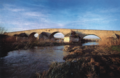 Roman bridge of Canosa di Puglia
 An ancient Roman bridge near Monteverde, Campania
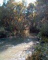 Through Cairano
![Oil painting Lungo l'Ofanto (1870) by Giuseppe de Nittis (1848–1884), Pinacoteca De Nittis [it], Barletta, Italy](//upload.wikimedia.org/wikipedia/commons/thumb/3/36/Lungo_L%27ofanto_%281870%29_-_De_Nittis.JPG/120px-Lungo_L%27ofanto_%281870%29_-_De_Nittis.JPG) Oil painting Lungo l'Ofanto (1870) by Giuseppe de Nittis (1848–1884), Pinacoteca De Nittis, Barletta, Italy
Oil painting Lungo l'Ofanto (1870) by Giuseppe de Nittis (1848–1884), Pinacoteca De Nittis, Barletta, Italy Tabula Peutingeriana showing ancient Aufidus and Via Appia


![Oil painting Lungo l'Ofanto (1870) by Giuseppe de Nittis (1848–1884), Pinacoteca De Nittis [it], Barletta, Italy](http://upload.wikimedia.org/wikipedia/commons/3/36/Lungo_L%27ofanto_%281870%29_-_De_Nittis.JPG)

References
- Talbert, Richard J. A., ed. (2000). Barrington Atlas of the Greek and Roman World: Map-By-Map Directory. Vol. I. Princeton, NJ and Oxford, UK: Princeton University Press. p. 675. ISBN 0-691-04945-9.
- The Times Comprehensive Atlas of the World (13 ed.). London: Times Books. 2011. p. 77 Q5. ISBN 978-0-00-741913-5.
| Authority control |
|
|---|
This Apulia location article is a stub. You can help Wikipedia by expanding it. |
This Basilicata location article is a stub. You can help Wikipedia by expanding it. |
This Campanian location article is a stub. You can help Wikipedia by expanding it. |
На других языках
- [en] Ofanto
[es] Ofanto
El río Ofanto es un río costero del sur de Italia, que desemboca en el mar Adriático. Típicamente mediterráneo, es un curso fluvial caprichoso, cuyas márgenes y, sobre todo el delta, gozan de ricas fauna y flora. Este río ha visto, en el curso de la historia, desarrollarse grandes civilizaciones, y pasar numerosas olas de invasiones, como la de los cartagineses, triunfantes sobre los romanos en la célebre Batalla de Cannas.[it] Ofanto
L'Ofanto ('ɔfanto, dal latino Aufidus) è il più importante fiume della Puglia per lunghezza, bacino e ricchezza d'acque; inoltre, con i suoi 134 km totali di corso, risulta anche il secondo fiume più lungo fra quelli che sfociano nell'Adriatico a sud del Reno (dopo l'Aterno-Pescara) e uno dei più lunghi dell'Italia meridionale dopo lo stesso Aterno-Pescara, il Volturno, il Basento e l'Agri.[ru] Офанто
О́фанто (итал. Ofanto) — река на юго-востоке Италии. Длина — 145 км, площадь водосборного бассейна — 2760 км²[1]. Течёт по территории областей Кампания, Базиликата и Апулия.Другой контент может иметь иную лицензию. Перед использованием материалов сайта WikiSort.org внимательно изучите правила лицензирования конкретных элементов наполнения сайта.
WikiSort.org - проект по пересортировке и дополнению контента Википедии