geo.wikisort.org - River
Mzymta (Russian: Мзы́мта, Abkhazian: Мӡымҭа, lit. 'the place (-ҭа) of the river Мӡым", Adyghe: Мэзмытӏэ, Mezmytha) is a river in Western Caucasus, Russia, flowing through Mostovsky District and the city of Sochi (Adlersky City District) of Krasnodar Krai, Russia. Mzymta is the largest river in Russia emptying into the Black Sea. It is 89 kilometres (55 mi) long with a watershed of 885 square kilometres (342 sq mi).[1] All the venues of the 2014 Winter Olympics were in the Mzymta Valley.
This article needs additional citations for verification. (May 2020) |
| Mzymta River | |
|---|---|
 Mzymta from Maidens' Eyewater waterfall | |
  | |
| Location | |
| Country | Russia |
| Physical characteristics | |
| Source | |
| • location | Greater Caucasus |
| • elevation | 2,980 m (9,780 ft) |
| Mouth | |
• location | Black Sea |
• coordinates | 43°24′57″N 39°55′25″E |
• elevation | 0 m (0 ft) |
| Length | 89 km (55 mi)[1] |
| Basin size | 885 km2 (342 sq mi)[1] |
| Discharge | |
| • average | 45.6 m3/s (1,610 cu ft/s) (near mouth) |


Geography
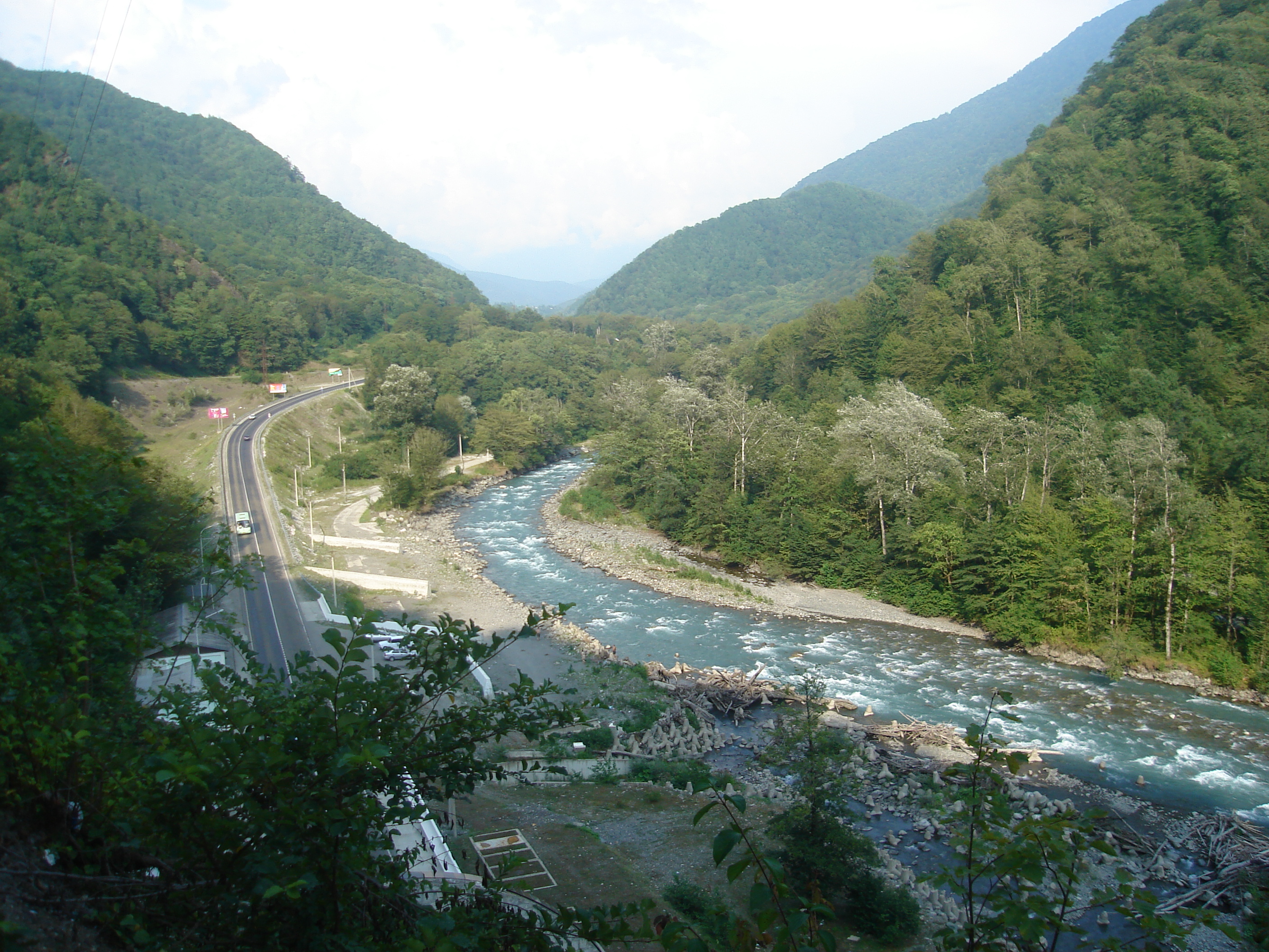
The source of the Mzymta is in Lake Verkhny Kardyvach in Western Caucasus, at the height of 2,980 metres (9,780 ft). The upper course of the river is located within the Caucasus Zapovednik. The Mzymta flows in a narrow valley through Lake Kardyvach and forms several waterfalls, the biggest of which is Izumrudny (Emerald), 15 metres (49 ft). Downstream of Lake Kardyvach, the river flows west and enters Sochi National Park. The banks are covered with beech forests and chestnuts, and also ancient Ubykh gardens with wild pear, walnut and chestnut. In Esto-Sadok and Krasnaya Polyana the Mzymta flows through the first urban area, where some of the events of the 2014 Winter Olympics took place. Downstream it turns south. The Mzymta comes through Akhshtyr and Dzykhra gorges, popular tourist attractions. Mzymta enters the Black Sea in Adler, where the rest of the Winter Olympics took place. At the mouth, there is a big talus train, dividing into branches across the floodplains. Mzymta carries out to sea large amounts of silt. Mineral springs are also found in the catchment basin. The river is fed by spring tides and rain freshets.
Mzymta is a floatable river, and the popular attraction is rafting. Krasnopolyanskaya hydroelectric power station has a reservoir with a daily streamflow regulation.
Average intensity of flow
- Krasnaya Polyana: 33.2 cubic metres per second (1,170 cu ft/s)
- Kepsh: 45.6 cubic metres per second (1,610 cu ft/s) (max 764 cubic metres per second (27,000 cu ft/s))
Major inflows
- Pslukh
- Pudziko
- Chvizhepse
Inhabited localities
- Estosadok
- Krasnaya Polyana
- Chvizhepse
- Kepsha
- Monastyr
- Galitsyno
- Kazachy Brod
- Vysokoye
- Moldovka
- Adler
References
- Река Мзымта (in Russian). State Water Register of Russia. Retrieved 1 February 2014.
На других языках
[de] Msymta
Die Msymta (russisch Мзымта) ist ein 89 km langer Fluss an der Südwestseite des Großen Kaukasus in der russischen Region Krasnodar.- [en] Mzymta
[ru] Мзымта
Мзы́мта (абх. Мӡымҭа) — река в Краснодарском крае. Длина реки — 89 км[2], площадь водосборного бассейна — 885 км²[2]. Самая длинная и полноводная река России из впадающих непосредственно в Чёрное море. Средний расход воды — у села Кепша — 45,6 м³/сек[3]. Среднегодовой сток Мзымты в Чёрное море достигает 1,4 км³[4].Другой контент может иметь иную лицензию. Перед использованием материалов сайта WikiSort.org внимательно изучите правила лицензирования конкретных элементов наполнения сайта.
WikiSort.org - проект по пересортировке и дополнению контента Википедии