geo.wikisort.org - River
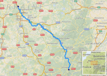
The Meurthe (French pronunciation: [mœʁt]) is a river in north-eastern France, right tributary to the river Moselle. It is 161 km (100 mi) long.[1] Its source is in the Vosges mountains, near the Col de la Schlucht in the Vosges département, from where it flows in an overall north-westerly direction. Its name gave rise to the naming of the present French département Meurthe-et-Moselle and the former (before the change in the Franco-German border after the Franco-Prussian war of 1870) département Meurthe.
| Meurthe | |
|---|---|
 The Meurthe in Nancy | |
 | |
| Location | |
| Country | France |
| Region | Grand Est |
| Physical characteristics | |
| Source | |
| • location | Vosges mountains |
| • coordinates | 48°03′25″N 7°00′50″E |
| • elevation | 1,190 m (3,900 ft) |
| Mouth | |
• location | Moselle |
• coordinates | 48°46′48″N 6°8′29″E |
| Length | 161 km (100 mi) |
| Basin size | 3,085 km2 (1,191 sq mi) |
| Discharge | |
| • average | 41 m3/s (1,400 cu ft/s) |
| Basin features | |
| Progression | Moselle→ Rhine→ North Sea |
Channelled during its route through Nancy, the river flows into the Moselle at Pompey on the northern edge of Nancy, a short distance down-stream from the Port of Frouard.
Towns along the river Meurthe include:
- in Vosges: Fraize, Saint-Dié-des-Vosges, Raon-l'Étape
- in Meurthe-et-Moselle: Baccarat, Lunéville and Nancy
Tributaries include:
References
Tributaries of the river Moselle | ||
|---|---|---|
| From the left | ||
| From the right | ||
Authority control | |
|---|---|
| General | |
| National libraries | |
| Other |
|
This Grand Est geographical article is a stub. You can help Wikipedia by expanding it. |
На других языках
[de] Meurthe
Die Meurthe, deutsch Mörthe (altdeutsch: Mörta, keltisch Murta), ist ein Fluss in Frankreich, der in der Region Grand Est verläuft. Sie ist mit einem mittleren Abfluss von über 40 m³/s der drittgrößte Nebenfluss der Mosel.- [en] Meurthe (river)
[es] Río Meurthe
El río Meurthe (en español áurico, Meurta[1]) es un río de Francia, un afluente del río Mosela por la derecha. Nace en la cordillera de los Vosgos, de la unión del Gran y Pequeño Meurthe, los cuales a su vez nacen cerca del col de la Schlucht y Ban, respectivamente. Desemboca en el Mosela entre Frouard y Pompey, tras un curso de 159 km por los departamentos de Vosgos y Meurthe y Mosela.[it] Meurthe
La Meurthe è un fiume del Grande Est e affluente della Mosella, a sua volta affluente del Reno.[ru] Мёрт
Мёрт (фр. Meurthe) — река во Франции.Другой контент может иметь иную лицензию. Перед использованием материалов сайта WikiSort.org внимательно изучите правила лицензирования конкретных элементов наполнения сайта.
WikiSort.org - проект по пересортировке и дополнению контента Википедии