geo.wikisort.org - River
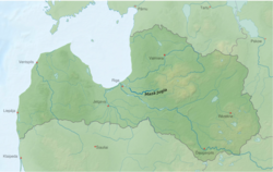
Mazā Jugla (previously German: Kleine Jägel) is a river in Latvia. It flows for 119 kilometres through the municipalities of Ogre, Salaspils, Ikšķile and Stopiņi. The source of the river is located in Taurupe parish, Ogre Municipality 130 m above sea level, whereas the mouth is 0.1 m asl.
This article may be expanded with text translated from the corresponding article in Latvian. (December 2009) Click [show] for important translation instructions.
|
| Mazā Jugla | |
|---|---|
 Mazā Jugla near Kranciems | |
 | |
| Location | |
| Country | Latvia |
| Physical characteristics | |
| Source | |
| • location | Taurupe parish, Ogre Municipality, Latvia |
| • elevation | 112 m (367 ft) |
| Mouth | Jugla |
• location | near Riga |
• coordinates | 56°58′10″N 24°19′24″E |
| Length | 119 km (74 mi) |
| Basin size | 675.3 km2 (260.7 sq mi) |
| Basin features | |
| Progression | Jugla→ Ķīšezers→ Mīlgrāvis→ Daugava→ Baltic Sea |
Mazā Jugla joins with Lielā Jugla thus forming the river Jugla shortly before its mouth into Jugla Lake at the Riga city eastern border with the municipalities of Garkalne and Stopiņi. The river is curvy with many rapids and weirs, with dolomite and sandstone outcrops on its banks, and is a popular water tourism site. The Dobelnieki hydroelectric plant is located on the river.
The Battle of Jugla of World War I between the German and Russian armies took place on the banks of the river in 1916.
See also
| Authority control: National libraries |
|---|
This Vidzeme location article is a stub. You can help Wikipedia by expanding it. |
На других языках
[de] Kleine Jägel
Die Kleine Jägel (lettisch: Mazā Jugla) ist ein Fluss in Lettland nordöstlich der Hauptstadt Riga.- [en] Mazā Jugla
[ru] Маза-Югла
Маза-Югла (латыш. Mazā Jugla, нем. Kleine Jägel, рус. Малая Югла) — река в Латвии, левая составляющая реки Югла. Длина реки — 119 км, площадь водосборного бассейна — 675,3 км².[1]Другой контент может иметь иную лицензию. Перед использованием материалов сайта WikiSort.org внимательно изучите правила лицензирования конкретных элементов наполнения сайта.
WikiSort.org - проект по пересортировке и дополнению контента Википедии