geo.wikisort.org - River
The Loup (French pronunciation: [lu] (![]() listen); Occitan: Lop) is a river in the Alpes-Maritimes department, Southeastern France. With a length of 49 kilometres (30 mi), it ends in the Mediterranean Sea in Villeneuve-Loubet, near Cagnes-sur-Mer.[1] It takes its source in Andon.
listen); Occitan: Lop) is a river in the Alpes-Maritimes department, Southeastern France. With a length of 49 kilometres (30 mi), it ends in the Mediterranean Sea in Villeneuve-Loubet, near Cagnes-sur-Mer.[1] It takes its source in Andon.
| Loup | |
|---|---|
 The Gorges du Loup in Tourrettes-sur-Loup | |
 | |
| Native name | La Liane (French) |
| Location | |
| Country | France |
| Physical characteristics | |
| Source | |
| • location | Montagne de l'Audibergue (Alpes-Maritimes) |
| • coordinates | 43°46′3″N 6°47′20″E |
| Mouth | |
• location | Mediterranean Sea |
• coordinates | 43°38′35″N 7°8′41″E |
| Length | 49 km (30 mi) |
| Basin size | 289 km2 (112 sq mi) |
Geography
The total length of the river is 49.3 kilometres (30.6 mi).[1]
The source of the Loup is north of the mountain of Audibergue in the municipality of Andon, a small town in the Alpes-Maritimes situated at nearly 1,200 meters (3,900 ft) above sea level and surrounded by small ski resorts.
The stream first turns east, then turns south and forms the Gorges du Loup, a series of gorges. After passing Bar-sur-Loup, it resumes its course towards the east, passes south of the city of Vence, then moves towards the south-east and arrives at Villeneuve-Loubet.
From there it flows into the Mediterranean Sea southwest of Cagnes-sur-Mer.
Hydrology
The water flow in the Loup was observed for a period of 34 years (1980-2013) in Villeneuve-Loubet, a commune in the Alpes-Maritimes department, located at its mouth at the Mediterranean Sea. The river's catchment area is 289 km2 (112 sq mi),[2] and the average flow rate is 4.480 m3/s.[3]
Cities and villages along the river
The Loup flows through the following cities and villages (source to mouth):
- Andon, Gréolières, Cipières, Courmes, Gourdon, Pont-du-Loup, Bar-sur-Loup, La Colle-sur-Loup, Villeneuve-Loubet
Gorges du Loup

The Gorges du Loup is a gorge carved by the Loup river in the Maritime Alps in France, about 45 minutes from Nice.
Waterfalls
There are several cascades in the gorge. Among them are the Saut du Loup and the Cascade de Courmes.
 Saut du Loup
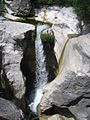 Saut du Loup
 Saut du Loup
 Cascade de Courmes


Climbing
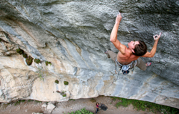
The gorge is a popular climbing area with several high-level routes, with at least 22 routes above the grade 5.14 (8c/+).[4] According to UKClimbing the gorge offers a total of 451 routes set in the French limestone.[5] The first free route in the gorge was Déversé Satanique, opened by Bernard Duterte in the mid 1980s. Now graded 8a+ (5.13c).[6]
9a difficulty routes
- Kick Ass - August 2012 - Enzo Oddo[7]
- Trip Tik Tonik - July 2011 - Gérome Pouvreau[8]
- PuntX - 12 August 2007 - Alexandre Chabot[9]
- Abysse - 28 July 2006 - Alexandre Chabot[10]
- Kinematix - 6 October 2001 - Andreas Bindhammer[11]
References
- Sandre. "Fiche cours d'eau - Le Loup (Y5610500)".
- Bassin versant : Loup (Le), Observatoire Régional Eau et Milieux Aquatiques en PACA
- "Le Loup à Villeneuve-Loubet (Moulin du Loup)". French Ministry of Ecology, Sustainable Development and Energy. Archived from the original on July 21, 2019. Retrieved March 18, 2020.
- "Routes in Gorges Du Loup for selected grade". Archived from the original on July 21, 2019. Retrieved July 21, 2019.
- "Gorges du Loup". UKClimbing. Archived from the original on Jul 19, 2017.
- "Gorgeous French Limestone at the Gorges du Loup's Deverse Sector". climbing.com. Archived from the original on Jul 21, 2019.
- "Enzo Oddo, 9a a Deversé". up-climbing.com. Archived from the original on March 5, 2016.
- "9a per Gérôme Pouvreau". up-climbing.com. Jul 31, 2011. Archived from the original on August 6, 2011.
- "Alex Chabot climbs the new may be hardest route in Deverse". czechclimbing.com. Aug 16, 2007. Archived from the original on July 21, 2019.
- "Alex Chabot sale Abysse 9a". planetmountain.com. Aug 9, 2006. Archived from the original on July 21, 2019.
- "Andreas Bindhammer libera KinematiX". planetmountain.com. Oct 26, 2001. Archived from the original on July 21, 2019.
Authority control | |
|---|---|
| General |
|
| National libraries | |
| Other |
|
На других языках
[de] Loup (Fluss)
Der Loup ist ein Fluss im Süden Frankreichs, der im Département Alpes-Maritimes in der Region Provence-Alpes-Côte d’Azur verläuft. Sein Quellbach Vallon de l’Audibergue entspringt beim Weiler La Moulière im Gemeindegebiet von Andon. Der Fluss entwässert im Oberlauf durch den Regionalen Naturpark Préalpes d’Azur zunächst Richtung Ost, später nach Südost und mündet nach rund 49[3] Kilometern an der Gemeindegrenze von Cagnes-sur-Mer und Villeneuve-Loubet in das Mittelmeer.- [en] Loup (river)
[it] Loup (fiume Francia)
Il Loup è un fiume francese che attraversa il dipartimento delle Alpi Marittime, nella regione della Provenza-Alpi-Costa Azzurra, e che sfocia nel mar Ligure.Другой контент может иметь иную лицензию. Перед использованием материалов сайта WikiSort.org внимательно изучите правила лицензирования конкретных элементов наполнения сайта.
WikiSort.org - проект по пересортировке и дополнению контента Википедии